Travel day is always exciting, but I could not get too excited until I finished work for the day. Luckily, I had put my out of office response on my emails the day before so I just had to tidy up loose ends and it was not too stressful. That said, I really need a holiday!
The hype for this holiday was great. I loved telling people I was going to the Caucasus and see their blank face, as most people don’t know where it is. Even when I named the countries, some were still none the wiser. I love going to unique places!
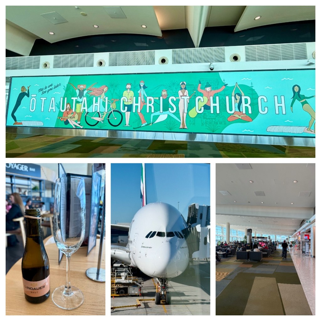
Today I was flying on the Emirates A380, straight from Christchurch, It’s a great route and a good plane, but I will miss the luxury of the lounge and perks I get with Star Alliance flights. Thankfully, I didn’t have any long stopovers scheduled so I knew I would survive. (I didn’t know it then, but this would come back and bite me later in the journey.)
It’s been a few years since I have had to pass time in the tiny Christchurch International area – 4 shops and 2 eating places lol. Still, there lots of places to sit, and I managed to occupy myself for the almost 3 hours by moving around the seating areas, reading my book and having a sneaky glass of bubbly.
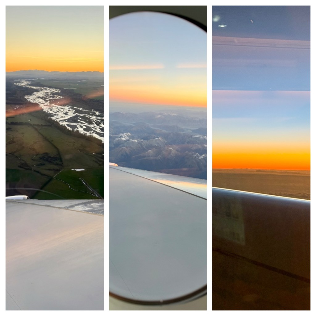
My first flight for the day was just under 3 hours, from Christchurch to Sydney. I did have a window seat but it was over the wing so not such a good view, but could still enjoy the beautiful sunset over the mountains as we took off.
After a couple of hours on the ground, I boarded my second flight, almost 15 hours to Dubai. Thankfully I managed to get some sleep to pass the time, and chatted with my seat companions – a couple who were on their way to a wedding at Antelope Aark in Zimbabwe, where I used to live! A lovely small world moment.
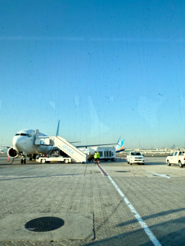
This is where my 2 hour layover bit me! In Dubai, I had been told, I had to catch a bus for 20 minutes to the next gate for my FlyDubai flight (Emirates budget airline). So we left behind the flashy Dubai airport as this side was more like a bus stop than an airport. The bus actually took closer to 30 minutes and by the time we arrived, my flight boarding had begun, and the mayhem started as soon as I got off the bus.
We had more security, with a long queue and lots of people pushing and shovelling …. so I joined the pushing and shovelling to get to the front so I could get to my gate. No time for the toilet or to fill my water bottle and oh, the cruelty of seeing a Starbucks but had no time to get a coffee.
To add to the connection stress, I was trying to confirm a pick up time for a night tour I had booked. The first message I received told me that pick up time was 2pm at the Old City gate … ummm but my tour starts at 6.30 and has a hotel pick … ok, they reply, we will pick you up at your hotel at 8.30!
Again, but my tour starts at 6.30 – and finally they said, we have changed the time because of the traffic! Is traffic is always bad at that time? If so, why sell a tour to start at that time, or were they randomly predicting it will be bad? A gentle reminder not to try and find logic as sometimes there just is none!
Sadly I had to cancel it as it was something to help me kill time before I could go to bed – the chance of me staying awake that late was very small, and I have 2 more nights in Baku so will hopefully be able to do it another night.
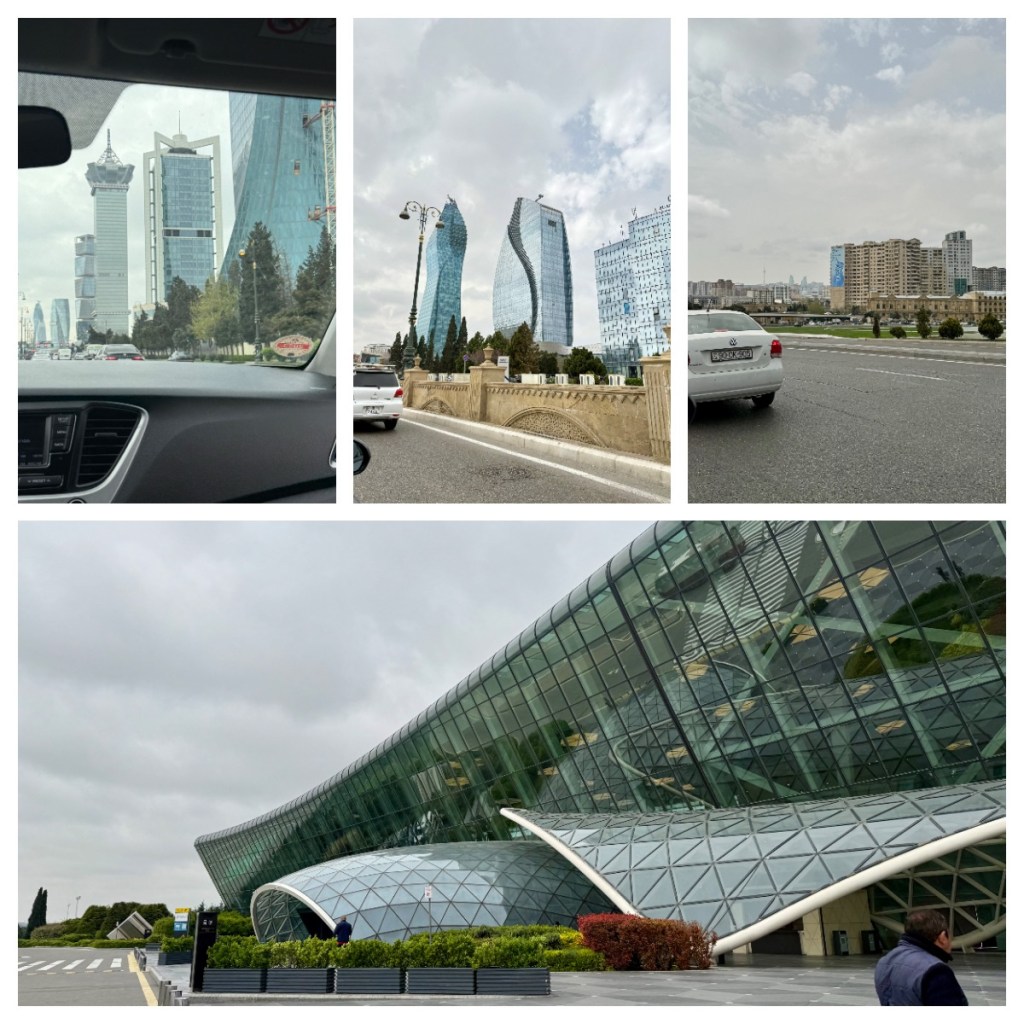
After all that stress, I was on my my final flight that took me from Dubai to Baku, the capital of Azerbaijan, sitting on the shores of the Caspian Sea. I was on the wrong side of the plane to see the sites of Dubai but got great views of the barren Middle Eastern landscapes and on to snow capped mountains.
Heydar Aliyev International Airportin Baku was modern and clean, and within 10 minutes of landing I was through immigration, waiting for my bag. (For Azerbaijan, I needed to get an evisa in advance so entry was easy with that in hand.) I changed a little money (to Azerbaijani Manat) while I waited for my bag, and 35 minutes after deplaning, I had my bag, found my driver for my pick up and was on my way to my hotel.
Initial views of the city were a mismatch of buildings ranging from Soviet style to hyper modern and wide European boulevard type streets. I am sure I will learn more in the coming days.
The hotel is nice, and after dropping my bag, I went for a walk to explore the area. Just down the road I came across a serious high end shopping mall, but thought it best to cross the street and go in to the more normal looking mall (with shops like Zara and Mango). It was cold, with a howling wind (I did not know that Baku is sometimes known as the windy city!) so I was grateful to be inside.
Was it wrong that my first meal in Azerbaijan was McDonald’s? Probably, BUT, I navigated the order in Azerbaijani and … it came with an incredible view that I may not have seen if i did not go there. So I think that balances out.
Never one to shy away from making the most of a stopover, I has decided to take the opportunity to get off the charter flight in Iceland, rather than travel through to Denmark. I said goodbye to everyone as I left the plane (there was only a handful of us disembarking there) and arriving in to Iceland was so easy. There was no immigration and I didn’t even see any customs. I just walked right through, bought a bus ticket and within about 30 minutes of getting off the plane I was heading in to the city of Reykjavik. (The bus was definitely the best option but was not cheap, at around $45 one way, better than a taxi that apparently cost $200!)
Despite Reykjavik not being a large city (population around 120,000 with only 400,000 in the whole country), after two weeks in small isolated villages, it was really like being back in the big smoke with all the people, traffic and American takeaway chains etc! The Airport Bus stopped at main bus station and then I took a small shuttle to the other stops in the centre of town (all included in the one price). I was pleased to see that the shuttle stop was just outside my guest house/hostel.
What a come down from my room on the ship 🥴. This is definitely back to reality with a bump but more like travel as normal – a crappy room in a large city 🥴. Still the location was good and I was going to be out most of the time. Once I dropped my bag my first task was to get some food and I found a nearby hotdog place (there seems to be a lot of hotdog places around). I am not sure how Icelandic the ”Iceland hotdog” is, but it was good and I was hungry!
It had already been a long morning and I was ready for a quick nap before heading out to take a look around the city. Unfortunately I was too late in the day for any of the city walking tours so I googled some walking maps to get a general idea of what to see and where it was.
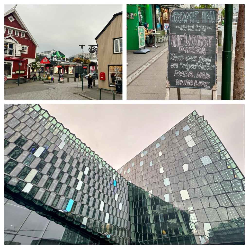
I started by walking up the “Rainbow Street”, or Skólavörðustígur (as it is more formally known) one of the city’s main streets which has been painted as a rainbow to celebrated the Rekjavik Pride movement. The area is also well know for it’s colour houses, street art and art installations.
The top end of the street is dominated by the famous Hallgrímskirkja church. At almost 75m tall, the church actually dominates the city skyline as it is among the tallest buildings in the country. Completed in 1986, the Evangelical-Lutheran church’s unique design is an ode to the Icelandic landscape and was named after the 17th century clergyman Hallgrímur Pétursson.
From the church I headed back down to the sea, and to the ‘Solfar’ or ‘Sun Voyager’ sculpture. It is a beautiful sculpture on the seafront apparently represents “a dream boat and an ode to the sun” however I think I join with most and thinking it looks like a viking ship – makes sense given that we are in the land of the Vikings.
I continued along the sea front to the next architectural marvel – the Harpa, Reykjavik’s concert hall which is home to the Iceland Symphony Orchestra and the Icelandic Opera. Completed in 2011, the glass façade of the building is made up of geometric shapes that represent the natural basalt columns you can see around the country, and the colour of these panels change with the light of the day.
I wandered around the harbour, into the small Ingólfur Square and around to the City Pond – a rather large ‘pond’ near the city centre. I walked through an area filled with tourist shops, tourist bars – English and Irish pubs etc. 🤦🏻♀️and a pizzeria thats marketing was based on getting a terrible review on TripAdvisor lol.
As I had a long day trip planned for the next day I tried to have an early night, but the down side of having some a central location is that it was very noisy with traffic and nearby bars and clubs! So, after a terrible nights sleep, a terrible coffee from a local convenience store (no coffee shops open early enough) and a shower in sulphur smelling hot water I was ready for the day lol. 🥴 (Apparently the water in Iceland is so pure it can go through taps without processing – I am not so sure as it also had a slight sulphur taste to it!)
The pick up point for the tour (and as it appeared every other tour in the country) was right outside my door, and I was glad that the guide had sent through the vehicle details so I did not have to rush up to each vehicle that arrived and we were soon on our way out of the city. I had been to Iceland before, many years ago, so choose to avoid the main touristy sites (which I had seen on my first trip) and the large bus tours and do a full day, small bus, south coast trip. Its worth noting that this choice was influenced by a google screen saver for an Icelandic waterfall I saw a couple of weeks before my trip lol. I had really wanted to see puffins but unfortuantely they had already left for the winter 😢, there is always next trip 🤣🤣.
Out Icelandic guide was called “Al” – kindly, Icelandic people always seem to anglize their names so of us who are linguistically challenged don’t have to try and butcher their actual name! Al was great, and full of interesting information, starting with some general facts.
Reykjavik, in the early 1900’s, was a small town focused on farming and fishing, but this all changed with WWII when the British built an airport (now the domestic airport, pretty much in the centre of the city) and then the Americans came bring more infrastructure and jobs. After the war, the airport was ‘given’ back to the country and Reykjavik soon became the thriving metropolis we see today.
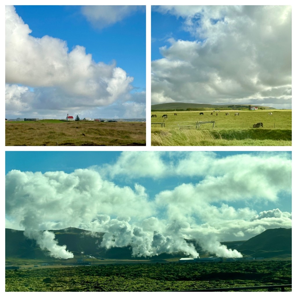
We headed out of the city on the ring road, which – not surprisingly, you can drive all the way around the country on it (if you have 6-7 days) and we learnt about the volcanic nature of the country. Now everyone knows that Iceland is full of volcanoes and of course eruptions in Iceland have caused flights disruptions, not only in Iceland but around the world! What I did not know was that they pump the hot geothermal water straight in to houses for hot water and heating – that will explain the sulphur smell in the shower!
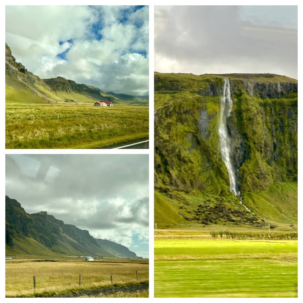
Apparently the weather this summer has not been great and we were blessed with an almost perfect day for this little outing and the landscapes we passed through were beautiful, ranging from volcanos, remains of old eruptions and beautiful volcanic cliffs lined with waterfalls to lots of beautiful green fields with horses (the famous Icelandic horses) and very shaggy sheep.
A couple of fun factors about Iceland according to Al:
· It’s unofficial motto is ‘it could be worse’ lol
· Beer was illegal until 1989! You also can’t by alcohol in the supermarket (so it is not too easily accessible), BUT you can get it on line and it will be delivered within the hour lol.
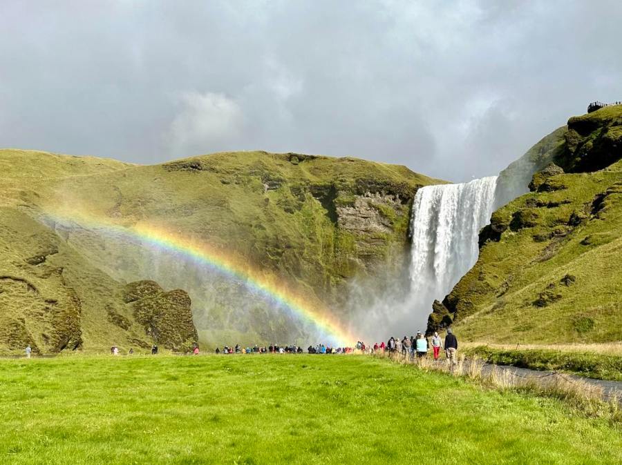
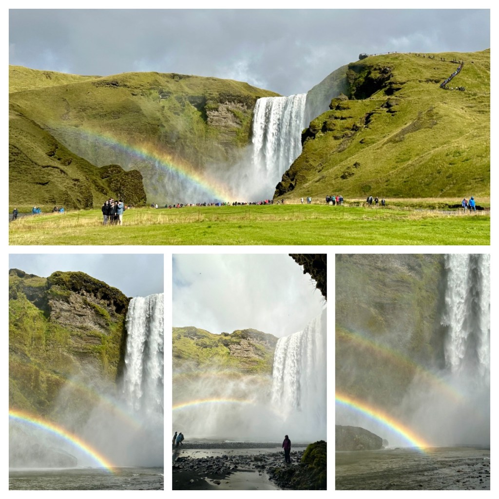
On the way to our first stop we passed the unimposing but infamous Eyjafjallajökull volcano, that caused all the travel issues back in 2010. It was know as E15 in the international press as no one could pronounce the proper name 😝. And finally our first stop, the google screensaver waterfall – Skógafoss. With a drop of around 60m and a width of 25m, it is one of the largest waterfalls in Iceland and today we were so lucky to have perfect conditions for the waterfall spray to create a double rainbow. I could have walked to the top, but by the time I finished taking photos from the bottom I didn’t have time 🤣. It was stunning.
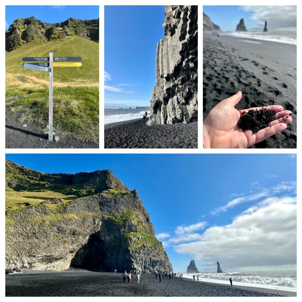
As we continued along the the south coast, we passed more stunning landscapes of glaciers, towering cliffs and waterfalls until we arrived at the famous black sand beach – Reynisfjara. It is famous for not only it’s black volcanic sand, but also for it’s tower basalt columns. Science tells us that these were formed by cooling lava and if you prefer a good local legend, they are actually two trolls turned in to stone as a curse.
As I previously mentioned, the puffins that nest here are already gone for the season but there were lots of Fulmars and gulls still hanging out on the cliffs surrounding the beach.
The beach is also famous for “sneaker waves” and there are warnings posted everywhere to watch out of these deceptively powerful waves that surge up the beach from calm looking seas.
Next we had a quick stop in the southernmost town in Iceland – Vik í Myrdal (more commonly know as Vik) to see the 1877 white, wooden church. Interesting the church seats around 450 people, and there is only around 600 living in the town.
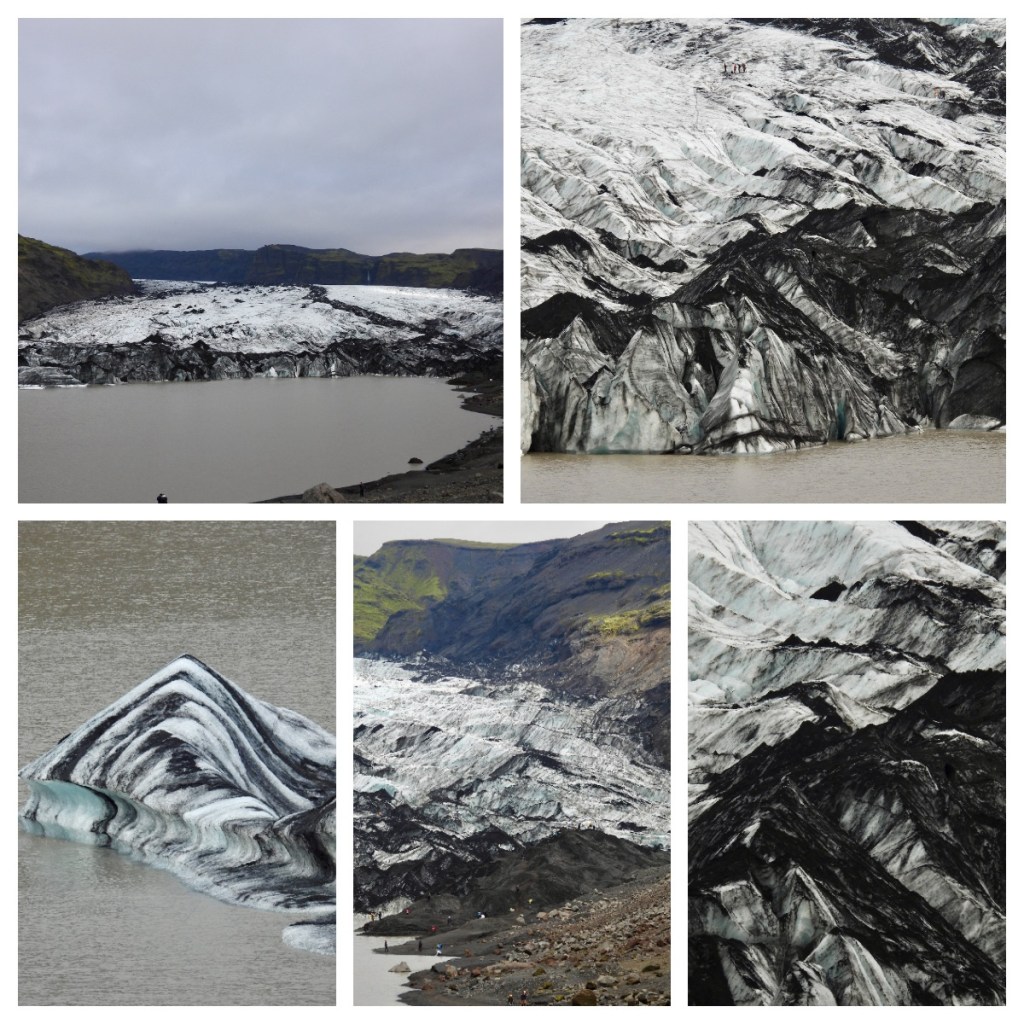
This was our turn around point and we headed back towards Rejavik but not without a couple of other stops. First at the most unique glacier I have ever seen – Sólheimajökull. The glacier and the icebergs in the glacier lake are actually striped, with layers of black volcanic ash through the ice! As with glaciers around the world, the glacier has been receding at a fairly fast rate and the lake we see today at the foot of the glacier has only been created in the last 25 years. That said, this glacier extends back around 14 km to the ice cap.
Our final stop for the trip was Seljalandsfoss, another iconic waterfall and this one we walk behind. Another 60m high waterfall but this one we could walk behind which was a little damp but fun. By now the clouds had rolled in now and the waterfall spray masked the rain that started to fall 😂 . It was a long day but great way to spend my one day in Iceland. I rounded it off my shouting myself Hard Rock Cafe for last dinner of the trip – not Icelandic but who I am going to kid thinking I am going to enjoy Icelandic fish – not me that’s for sure 🤣🤦🏻♀️.
I had called early in the day to book my pick up for the airport bus to be told my pick up would be at 3am 🥴 and I was so glad the stop is right outside the hotel! The early bus meant I arrived at the airport at 4.20am and after using the self check in, I easily made my way through the airport until I was ‘detained’ my the immigration guy as he told me a long winded story about some random guy in the 1800s who moved to Hobart – not sure if he thought Hobart was part of NZ or that NZ was part of Australia 🤔. Thankfully, there was not a long queue behind me! It was nice to have another stamp in my passport as I haven’t officially left Denmark, Canada or Greenland 🤣
As I boarded my first flight on the long trip home I was amused to hear Icelandic Air playing a Björk song as we boarded – classic 🤣. So that is it for my big trip for another year, now on to booking my big trip for 2025. Something for all readers to look forward to 😜.
Our final full day in Greenland was spent sailing south whilst we had couple of talks. Firstly we were given a briefing about the disembarkation process for the following day and house keeping that needed to take place e.g. return boots, pay bills etc, followed by a talk on the Geology of Greenland. This was followed by a session with Julien, the incredibly accomplished guide I have previously written about. It was basically a Q&A entitled “everything you need to know about Greenland and more”.
He covered topics from the development of Greenland (mainly fishing in the north and farming in the south), I quote “no one is living in igloos wearing polar bear pants”🤣 He went on to say that education is a problem – most people just fish or have technical education and that boys work with their father or uncles so don’t see point of higher education.
Most high school teachers are from Denmark and many children don’t speak Danish these days, as more and more are speaking English. For this, amongst other reasons, many fail at school and give up. Most educated people in the country are women who stick it out at school longer than the boys.
We pulled into our last stop during lunch and I spotted the chef fishing for dinner 🤔 off the ship lol.
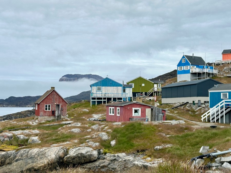
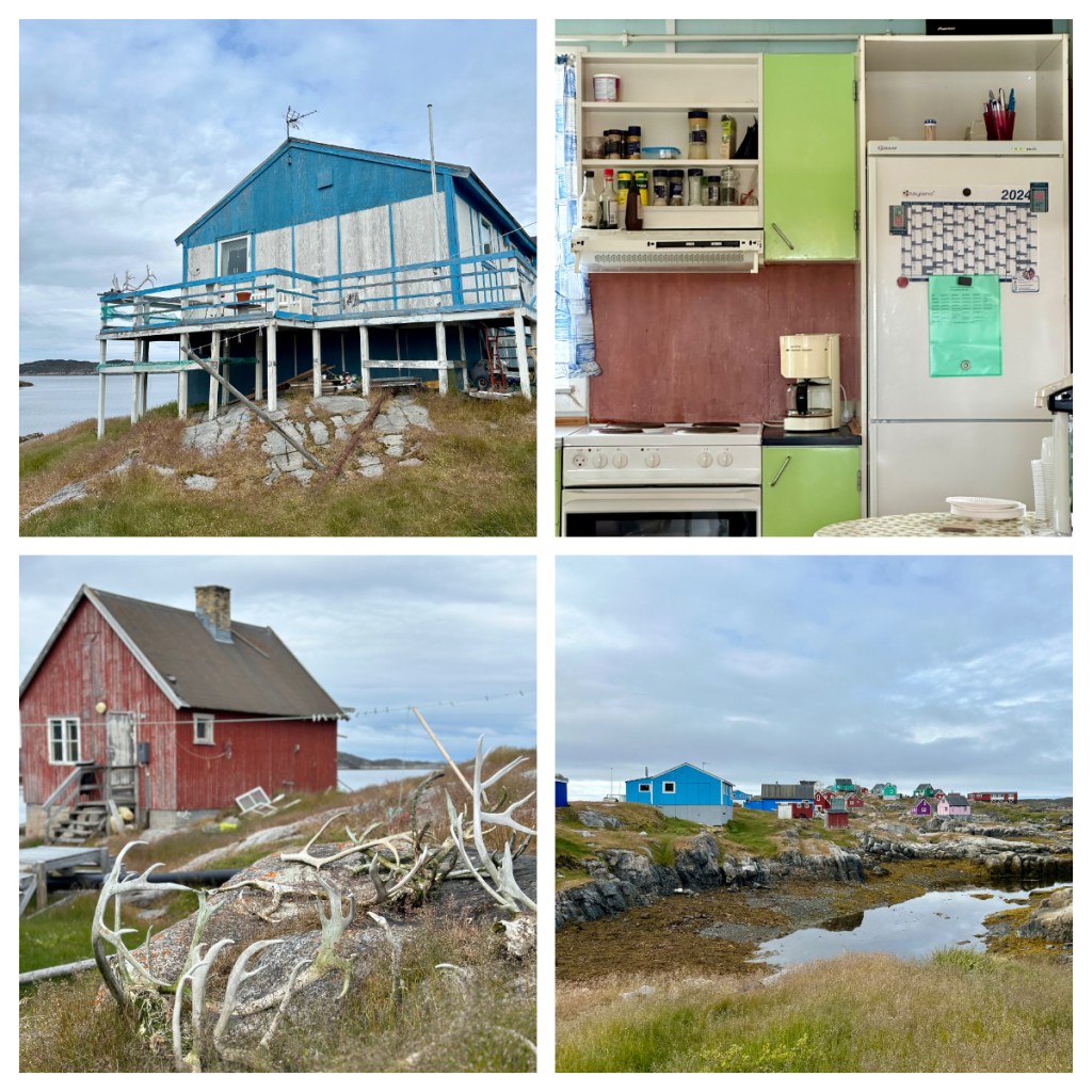
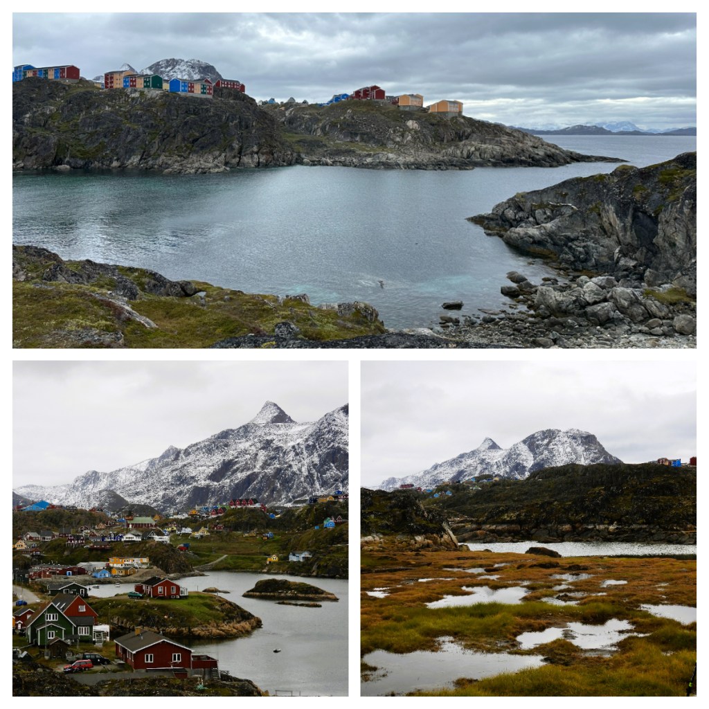
The afternoon was spent in the small town of Itilleq, located on a small island just of the coast of the mainland – population around 100! The island has no fresh water, so they have a facility for desalination of the sea water and as with all Greenlandic towns, there are no roads to get here, and in fact the closest airfield (for planes) is in Sisimiut, 45 km away across the sea. The town does however have a helipad for on-demand air services and emergencies.
The main trade in the settlement is fishing and hunting, with a fish factory being the main employer in the settlement. There is one store in the town – the local Pilersuisoq store.
It was a quaint town surrounded by beautiful mountains and after some time to wandered around we had an opportunity to go into one of the locals house’s for tea. The house had a 70s vibe decor and it was not dissimilar to houses in Fiji with colours, décor and religious icons.
Our hosts did not speak English well, but we had one of our guides with us who had lived in Greenland as a child. She explained that after World War II, the Danish government started 5 companies including Royal Greenland (the fishing company), Royal Artic Line (shipping), Air Greenland (transportation) and Pilersuisoq (a chain of general stores). Apparently, these companies must operate in all towns, even if they run at a loss. By law, Air Greenland must operate flights, even if the planes are empty. If this is the support currently given by the Danish government, I am not sure if Greenland will ever want, or be able to sustain true independence?
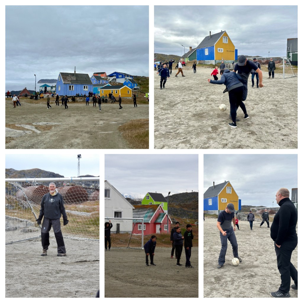
As all the village kids played in the Jacuzzi on the ship, ‘crowds’ gathered on shore for the all important football game between the town and the ship. Even the local fish factory closed early so the workers could play! All players welcome, any age, any size and any number of people were on each team lol! It was a lot of fun and a great way to end the day and the trip.
After our final dinner, it was time to finish up packing as our large bags had to be left outside our room before 11pm. As annoying as that was, it meant that it was taken up to the lecture room for the morning where we would be joined by check in staff from the airport who would then whisk our bags away to the airplane later the next morning.
I must admit I felt a little like a fish out of water on this trip with 95% of passengers not having English as a first language, hardly any other solo travellers – in fact I think there was actually only 1 other travelling on their own, and 4 travelling with a parent. Anywhere I sat for dinner threw out the dynamics of any of the tables as they were all set for 2,4, 6 or 8. That said, it did work in my favour a lot as it meant I got my own room when I had paid to share.
On top of that, most of the other passengers were Danish couples in their 60-70-80s (clearly a marketing thing) so it was not easy to get involved in conversations! Despite all of that, I met some lovely people and the ship and trip has been amazing. And lets be honest, if I was not comfortable with my own company, I would not travel solo! Next time, however, my next expedition cruise will be more wildlife focused 🥴
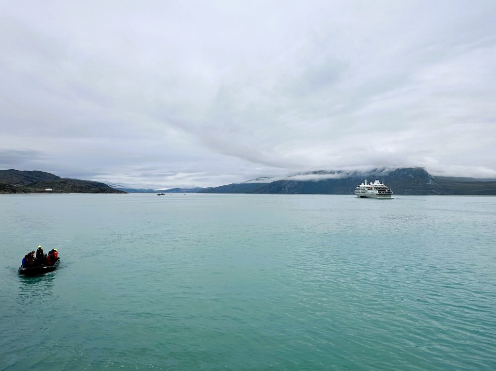
Our last evening saw us sailing south in to the mist, just how we had set off a couple of weeks earlier when we arrived and the final morning was bitter sweet. As I mentioned above, our flight check in was done on the ship and it was then time to jump into the zodiacs and leave the ship for the last time. Can I just say I won’t miss my waterproof pants 🤣!
Back in Kangerlussaq, I had booked to do a tour of the ‘city’ (I had booked all the extras in advance, not wanting to miss anything lol). I am not sure if I would have booked this tour now, but there is nothing else much to do there while waiting for the plane so I was happy to have something to do.
We jumped in to a big bus and headed out of town on Greenland’s longest road which starts at the harbour where we got out of the zodiacs. This is actually 14 km from the ‘town’ as the silt build up from the melting glaciers means this is as far as the large ships can get to town. At low tide, a small channel needs to be dredged to allow the zodiacs to get to shore!
From the town, it is a further 36km to the ice cap (which we had driven on our first day) making the road 50km in total. Apparently, part of the gravel road was built by Volkswagen in the late 90’s as a venue for car endurance testing. They had planned to extend the road on to the icesheet itself, but the plans were abandoned in 2005 and it is now mainly used for tourism.
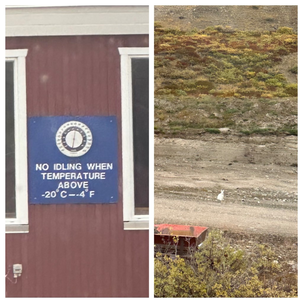
We did see a couple of Artic hares on side of road (👍🏻👍🏻 yay for some wildlife) but I did not have my camera on this trip so no great photo 🥴, but I saw it and I was happy!
We drove back through the town towards the airport and to be honest we didn’t learn too much more as the driver was from Denmark and had only been here for 2 months! Anyway, the little excursion killed some time and we were dropped back at the airport for our plane.
The trip had some ups and downs but overall it was amazing and it is no surprise that I would love to come back to explore other parts of the country or experience it at a different time of year.
I had visited this year as I had suspected that the new airport being built in Nuuk would result in direct flights from American – making these remote places more accessible is great I am sure for the country itself, however it makes it a little less adventurous for me, not to mention it being overrun with Americans who are only there because it is ‘easy”! My suspicions came true this week when direct flights were announced for Summer next year! Greenland will never be quite the same again.
Our next stop was at Disko Bay, a large bay sitting above the Artic circle and we started on the island of Qeqertarsuaq (“Big Island”), also know as Disko Island. The island is the largest island in Greenland, and has a population of around 850 people. Once known as Godhavn or Good Harbour, it served as the political and economic capital of Northern Greenland, it’s economy being based around the whaling industry. As the whaling industry collapsed, so did Qeqertarsuaq’s importance and the government functions were all moved to Nuuk.
This part of the country is now sea ice free all year round, this line used to be much further south, around Sisimiut.
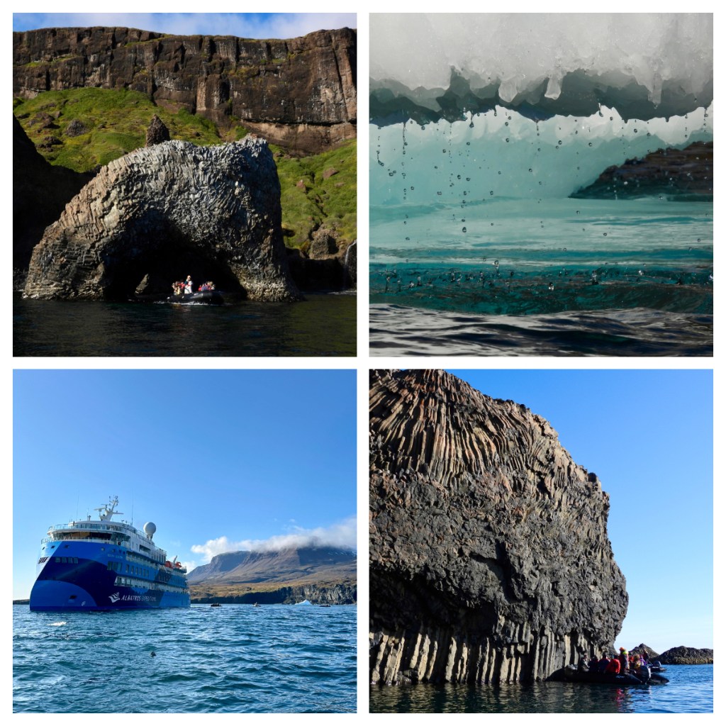
Unlike the Greendland mainland, Qeqertarsuaq consists of volcanic rocks, mainly basalt which means the soil is much more furtile leading to the island being much more green and lush than the rest of the country. It also provides some spectacular rock formations.
As we pulled in to the harbour of the small town I saw what I thought was hills/mountains in the background. It was in fact icebergs, floating on the other side of the land 🤯. So cool.
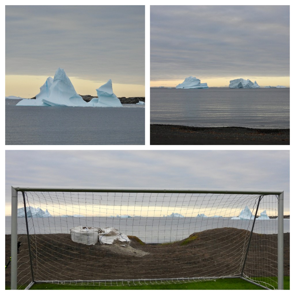
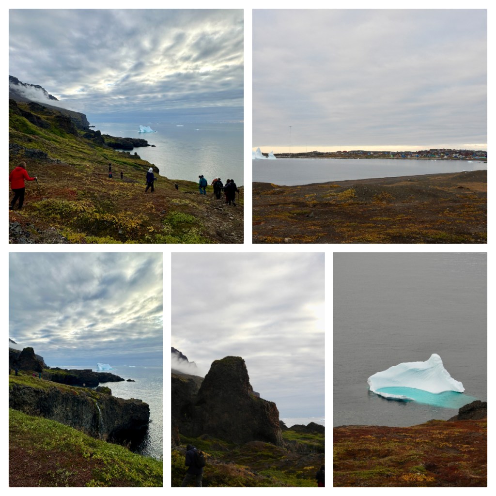
I had chosen to go on the long walk today, and for a change, it was fairly long. We started by strolling through the small picturesque town and then out the other side, passed what can only be described as one of the coolest, if not the coolest football fields in the world. Where else could you play a game of football and watch huge icebergs float by, just off the shore.
We then walked across a beautiful plateau and up in amongst the rock formations. There was only one really steep part, and the rest was relatively easy, but WOW, what views. From the high balsalt cliffs on one side, to the ocean and large icebergs on the other. The landscape just blew me away I wished I could have more time. As it was, I stayed out so long, I did not have time to look around the town and was actually in the last zodiac back to ship. I must admit, the photos really do not do this place justice!
I decided to have lunch on Deck 8 today so I could enjoy the views of the icebergs as we sailed out of the harbour. Finally a day where I felt like I earnt my lunch with a 10km walk! The short journey took us around the side of the island to the area of Kuannit, where we had walked along in the morning.
I had to wait until 3pm for my turn on the zodiacs this afternoon but it was worth the wait. The landscape was spectacular as we zipped up the coastline and around (and in one case through) the icebergs.
As mentioned previously, Disko Island was formed differently, geologically speaking, than the rest of the country. While the rest of Greenland is made up of really ancient rocks (billions of years old), Disko Island is relatively young, at only 60 million years old. It was formed as the mainland was splitting apart from North America and is more similar to the volcanic rocks of Iceland.
There are lots of visible rock layers, including some red bands that are from lava flows which have become iron filled soil. Where rock has eroded, basalt columns have been formed and the next lava flows fill in the gaps and cools to form the swirling patterns in the rock we see today.
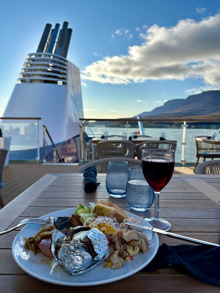
Back on the ship and I wish everyday was like today. To top it off, we had a BBQ dinner with mulled wine on the deck💚. Greenland was definitely saving its best till last! But wait, if I thought our day on Disko Island was amazing, the next day was possibly even better!
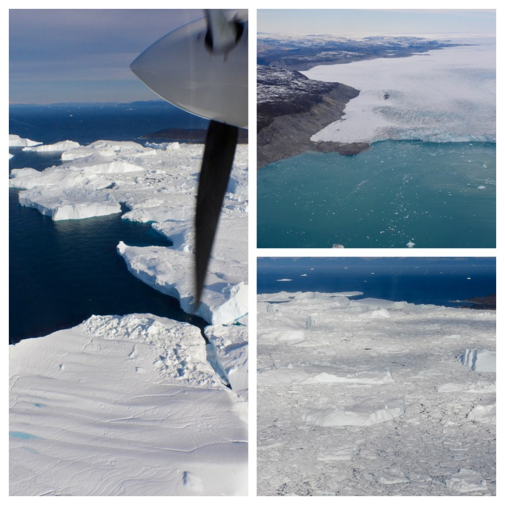
The next day saw us arrive offshore of Illulissat, 250km north of the Artic Circle, population around 4,500 and known as the Iceberg Capital of the World. In fact Illulissat is the Kalaallisut word for Icebergs! The Illulissat Icefjord is the source of most icebergs in the North Atlantic and the most likely source of the iceberg that sunk the Titanic!
The Illulissat Icefjord is one of the few places the Greenlandic ice cap reaches the sea and has been on the UNESCO World Heritage List since 2004. My plan for the day was to see it from the air, land and sea.
The Zodiac to shore was an assault on the senses as we arrived in to the harbour to the aroma of fish and fat filling the air 🥴. I am not a fan of the smells from the fish processing plant, but it has been the key industry here for 100’s of years. Today, Tourism is catching up.
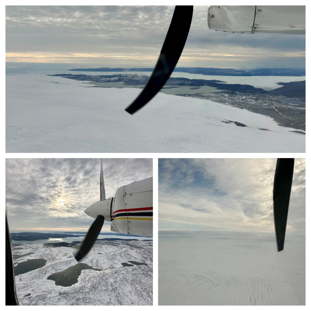
First up on my agenda for the day was a scenic flight over the icefjord and I was picked up, along with my 4 flight companions from the pier and taken out to the airport for our preflight briefing. I must admit I was kicking myself for not coming out early for a walk around the town before my flight … I think 10 days on the ship have made me lazy!
We took off in our AirZafari Vulcanair Partenavia P68 airplane, with only 6 seats (including the pilot), everyone got a window seat, although my view was a little obscured by the propellor which appears in many of my photos lol. The conditions were great, a little bumpy in the take off but smooth once we got in to the air.
As we flew out of the airport and over the glaciers, our pilot gave us a few facts:
The Icefjord is 75km long from glacier wall to sea
It is 17km wide and the most productive glacier in the world
I could not stop taking photos – every time the light changed it was a different kind of beautiful 💚. The flight was not cheap but it was an amazing way to see the glaciers and fjord full of ice and I have no regrets about splashing out on this.
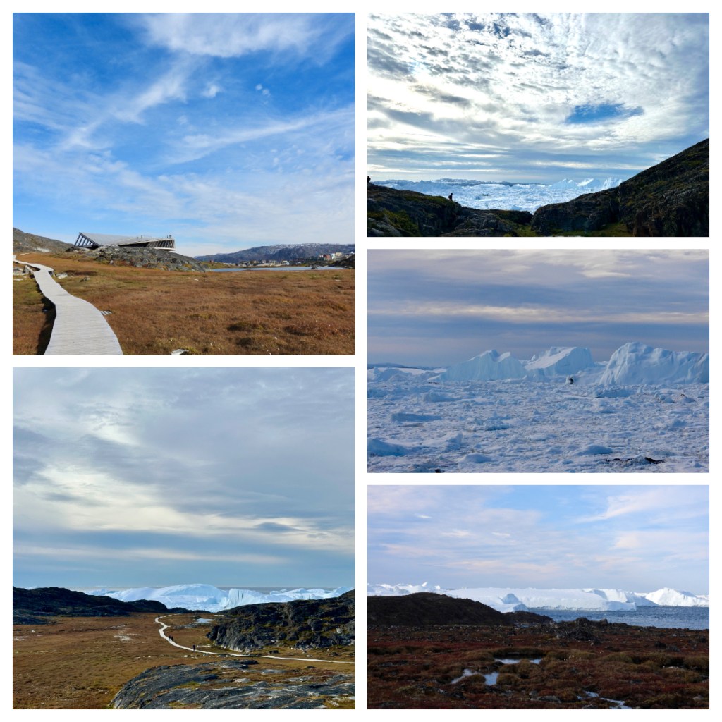
After our short flight, we were dropped back in to town and I shared a taxi with a couple of my fellow fliers to the Icefjord Centre a short distance out of town. I had to be back on the ship for 2pm for a boat trip so was a little concerned about being short of time to walk both ways.
The Icefjord Centre is a stunning building, apparently shaped like a “twisted structure miming the wingspan of a snow owl”. I am not sure I got that, but it certainly fitted in to the landscape that surrounded it. Inside, houses an exhibition of the “tale of ice” but as I was limited for time I had to keep on the move.
A boardwalk weaves it way down towards the sea and the stunning icefjord beyond. Even from the centre, you can start to see the icebergs floating by, and every step closer just brings more spectacular views.
As with the flight, I took so many photos as every step gave me a different and equally impressive view. The whole area was so well managed to protect the local flora while still providing the most amazing viewing opportunities of the towering icebergs. Here we are seeing the icefjord at the point where it meets the sea and the pilot on the flight this morning had told us that the largest icebergs are so big they get stuck at the mouth of the fjord where it is shallower, and they sit there until they melt a little and can float free. For this reason, some of the icebergs here are huge!
Unfortunately, as I was still rushing to get back in time for my boat trip, I could not loiter but I was pleased I go as far as I did and I still had a little time to walk down through town back to the pier.
I passed the dog kennels on the outskirts of town. As with Canada, the working dogs are all kept together in an area outside of town, and it is also a way to keep them away from other breeds of dogs so not to contaminate their bloodline. Given that they are not far from the Icefjord centre, they could be heard load and clear!
Unfortunately, my trifecta of activities failed as I arrived back at the pier to hear that my boat ride had been cancelled due to the wave conditions. A real shame, but I was still thrilled to have seen the icefjord from air and foot. After to speaking to someone who had been on one of the boat trips that did go out, I was grateful not to go as he told me it was so rough that they could not go outside the small cabin on the boat and people were throwing up! Back on our stable ship, you would not have guessed it was that bad!
Another amazing day, and as we set sail south our evening briefing was interrupted as we passed the amazing icebergs – no one wanted to sit inside and listen when the views outside were so amazing! 💚
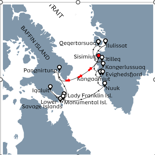
After our day in Pangnirtung, we started our trip back across the sea to Greenland which of course meant time changes again – 1 hour the first night and 2 hours the second. As there was not much to do on the sea day (thankfully there are only 2 full days at sea on this trip, one of the reasons I chose it) I thought I would do a little ship tour as I watch the icebergs float by in the distance.
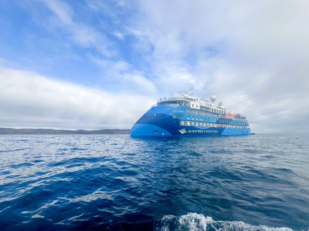
The Ocean Albatros is just over one year old and definitely the nicest expedition ship I have been on. She is Polar code 6 and Ice class 1A rated ship, with an x-bow Infinity class which apparently provides high stability – I can certain say that although the weather was never particularly bad, sailing was generally very smooth. She also uses dynamic positioning which means they don’t often need to use an anchor to stay in place, and, she is powered by low energy consumption engines which are designed to reduce emissions.
My room (one of 94) is great (better than some hotel rooms I have had) and having it to myself is a dream. I am on level 4 of the 8 story ship. The mud room is on level 3 – the area where we put on our waterproof gear and life jacket and get in the zodiacs.
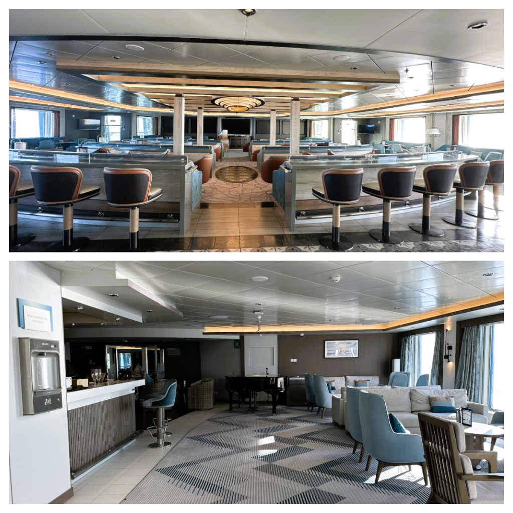
Level 5 is the main congregation space with the lecture room, bar, small library, main reception and the restaurant. A great thing about this ship is that the lectures are broadcast on the TV in the rooms, so if I don’t feel like going to the lecture room, I can still watch them.
Breakfast and lunch are buffets and dinner is ala carte with free wine or beer. The wait staff are very attentive when it comes to filling up our wine glasses but it is often difficult to get a water refill 🥴.
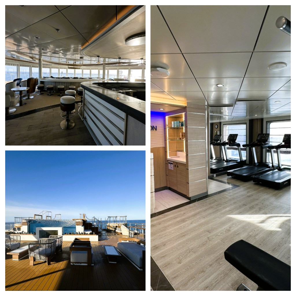
Level 7 has the main outside area, including lots of nice chairs (which are often too wet to sit on lol), a small pool (which has been empty on this trip) and 2 small hot tubs which seem to get used a lot! This level also has a small gym and a spa – neither of which have used 🤪.
Level 8 has another small restaurant which serves the same buffet breakfast and lunch but without the queue, the observation lounge which is a great place to relax with a view and some more outside deck area.
During today’s voyage we had talks on Whales and Greenlandic hunting. All of the expedition staff have varied and interesting backgrounds, but one is truly exceptional. A French man who was a professional action sports athlete (including BASE jumping, ice climbing, paragliding etc) as well as being a commercial helicopter pilot, and then settled in a small Northern Greenlandic village with a Greenlandic wife and for the last 17 years has lived the life of a traditional hunter and fisherman, leading expeditions on the ice cap in his free time.
I learnt that basically, Inuit can hunt anything, including whales and dolphins, polar bear, seal and things that hunting for most in the world is banned. They use everything, food for humans and dogs, skins used for clothing etc. All things have quotas etc to manage the populations and much of the hunting must be done traditionally e.g. narwhal can only be killed from a kayak with a harpoon, and it is forbidden or use speedboat.
For some things like musk ox, there is a lottery to see if you can hunt them that year and the Ministry of Hunting and Fishing set quotas and provide licenses. Commercial hunters need to complete forms confirming their hunts the previous year to get their license for the next season. Mostly all hunters respect the rules.
Now I know most of the other people don’t speak the same language as me (pun intended) when they all cheered that we don’t need to go to shore in zodiacs tomorrow – that is my favourite part 🥴!
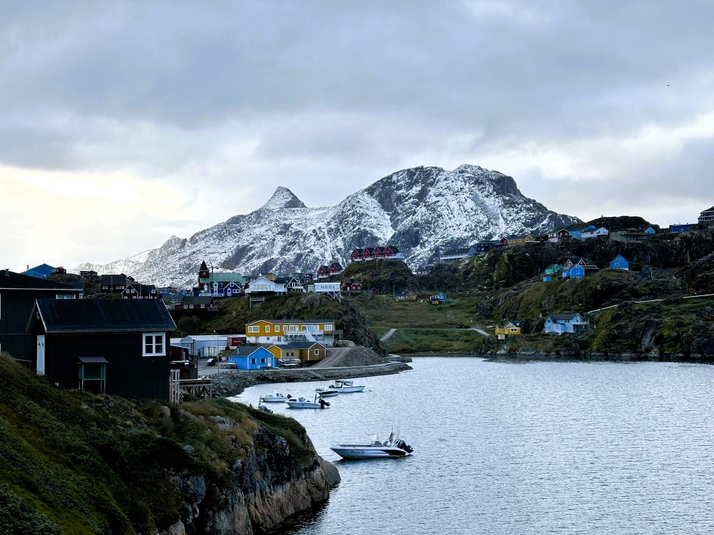
Back in Greenland, our first stop was the town of Sisimiut, meaning “the people living in a place where there are fox dens”. With a population of around 5,500, it is the second largest town in Greenland, after Nuuk.
The area was initial settled around 4,500 years ago, and like much of Greenland, it has seen settlements by the Saqqaq culture, Dorset culture and the Thule people, whom much of today’s people descend from. As it is Greenland’s northernmost year round ice free port, it is one of the main shipping based for western Greenland.
I opted to do another walk today and the walk took us to Tele Hill, not surprisingly the site of the telecommunication towers for the town. (I must admit I did take a couple of photos of the towers to bring back to my colleagues who are currently designing and working on site builds for similar towers in New Zealand lol.)
It was a fairly easy walk and the views back to town were stunning, the water beautifully clear and the route was dotted with historic ruins of house and other buildings, dating back to the 1600’s. I must admit you did have to use some imagination to see the footprints of some of them. 🥴 Thankfully there were good interpretation panels dotted around the sites, helping with the identification.
Near the telecom towers, the visible rock piles are unexamined graves – because they are unexamined, it is impossible to know just how old they are, but they are considered to be later than the likely Saqqaq culture settlement that dates back to 2300-1200BC which was also on the site.
As we wandered back towards town, we learnt about the historic use of colours that are part of the traditional Greenlandic towns. Yellow indicated a doctor’s house or a hospital. Red is reserved for big churches, museums, schools and other cultural centres. Blue was for fisherman and black for prisons and police stations. These are not so strictly adhered to today and sometimes houses are painted in the colour of paint that came on the last ship!
Despite saying above that church’s are red, Sisimiut has a blue church (although it does have a red roof) – the Bethel Church. Built in 1775, it is built on rock so as not to sink into the permafrost (a never ending problem) and is the oldest church in the country.
After a lovely morning walk, I headed back to the ship for lunch before heading out again, this time to the town where I found a lovely little café with good internet. I enjoyed a half decent coffee whilst catching up from news from around the world, but I passed on the minke whale in soy sauce the café also sold! 🥴
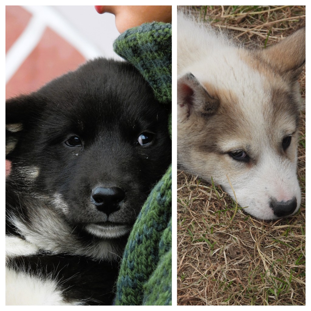
It was then my groups turn to enjoy some of the activities the town had put on for us. One of the most popular was the Greenlandic sled dog puppies or Kalaallit Qimmia. A large breed of huskie that is a national icon and important part of the Greenland identity. The breed are descendants of dogs brought to Greenland by the immigrating Inuits and even today, provide an important role in the life of Greenlanders. And let’s be honest, all puppies are adorable!
Couple of fun facts about Greenlandic Sled dogs … Firstly, they have a double coat which consists of a dense undercoat and a rough outer coat which provides the insulation needed to live in the Artic (where temperatures can drop to below -50C). And secondly, they are known for their stamina and strength and they can travel for long distances without tiring. Apparently, they are the only animal that outrun humans over long distances because of they way they burn protein without glycogen/carbs!
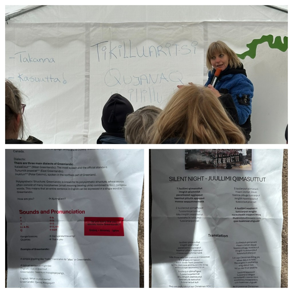
Next was an introduction to the Greenlandic language – which proved to be a major challenge for me but it was really interesting and the ‘teacher’ made it fun. Greenlandic is similar to all Artic and Inuit languages and for a long time it was only an oral language until missionaries wrote it down (in particularly for bible translations).
Some Greenlandic words are very long, and one word actually forms an entire sentence e.g the Greenlandic word for harbour, literally translates to “place where the skin boats are”. Did you know we used some Greenlandic words (perhaps the same in other Inuit languages) in English. Kayak, Igloo and Anorak are three that have Greenlandic origins.
A few of the other challenging ‘basics’ of the language are; all t’s are pronounced d’s, k = g and rl and ll have a sound I can not say or spell 🤣🥴. To round off our lesson we have to sing a song (it was to the tune of Silent Night) in Greenlandic – no sure we were particularly successful lol but it was fun.
Next up was authentic local food tasting and not surprisingly I did not try much. Unadventurous maybe, but I don’t like fish at the best of times so I can’t see that raw whale is going to work for me (I know not technical fish). Delights included Cod (dried and flaked), mattak (raw whale skin and blubber), raw seal, Capelin (a local fish that looks like a little sardine served whole), dried whale and the famous Greenlandic shrimp (a deep-sea shrimp, or prawn depending on who you talk to, is a huge export via Royal Greenland). I did succumb and tried the dry whale, it tasted like a very fatty biltong. The kind of fat that you just can not get out of your mouth 🥴.
Back on the ship, we were treated to a demonstration of kayaking by a Greenlandic kayak champion. He was rolling under water and paddling upside down🤣. He must have been freezing but I guess he is used to it as these are the skills kids learn to keep them safe when hunting and fishing from kayaks.
Today I chatted to some new people on the hike. I noticed an Australian accent for the first time – turns out he has been living in Sweden for 50 years so it is probably just the first time I have heard him speak English. I also chatted with a lovely Danish lady named Greta. He husband apparently has Covid and they have both been isolating in their cabin. She has now been allowed out but her husband is still unwell and confined 🥴! It was a win for me as I really enjoyed our conversation.
We all know how much I love a sunrise so I was pleased to be up just in time for it this morning. The time difference across the sea is 3 hours. So, to even that out, we put the on-ship clocks back two hour last night and a further one hour tonight.
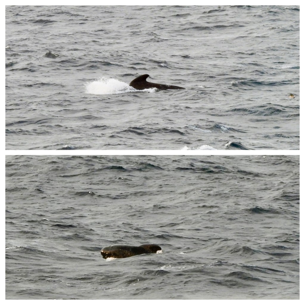
Clearly, last night was not the right time to skip dinner (which I had done because I had eaten so much during the day lol), as I was wide awake and starving early and there is no food to be had until what my body thinks is 9.30am 🥴 not even a biscuit in sight. Thankfully a pod of long finned pilot whales swam by to distract me a little 👍🏻. Whale sightings are always a great way to start the day.
As we crossed into Canadian waters we have a talk about seabirds. I must admit I was surprised by the lack of bird life so far. I am sure I remember in the Sothern Ocean, always being surrounded by large flocks of sea birds but here not so much. Despite that, I did spend some time on deck trying to take some bird photos and surprisingly got a photo of another whale. 😂. Not a good photo and it was hard to get an ID but possibly a Sei whale. I did also get a couple of half decent shots of the Northern Fulmars, who seem to be the most common birds we are seeing around the ship.
Being at sea meant a pretty relaxed day, and I think the jet lag was finally catching up with me so I took the opportunity to get some extra sleep but as the day wore on I had to head back up to the top deck to watch the big iceberg’s floating by on the generally calm seas. One of the icebergs had a large flock on kittywakes (I think) roosting on it which helped to give some perspective to just how large these icebergs are!
In the afternoon we had a talk on human migration in the region. An incredibly complex topic and one which I am not sure I fully understand, or could give any justice to here, but in a nutshell … many different Inuit people arrived at different times over the last 4,500 years and from different directions. They had various levels of success, the most successful seemed to be the Thule people who had bows and arrows for hunting, and were already using kayaks and dog sleds. They also used iron, some of which was sources from a meteorite which was found in the north of the Greenland.
Then came the Norse (basically Vikings) lead by Eric the Red in 982AD, a convicted murderer who had been banished from Iceland. Apparently, he is responsible for the name Greenland, thinking it would attract people to move from Iceland. They established two settlements and stayed around until the 1500s when another ice age meant they could no longer farm so had to move on.
The Dane’s arrived in south western Greenland in 1721, setting up seasonal trading posts and churches to convert the local Inuits. Today, despite being the ‘ruling’ country, Danes only make up 11% of the population, and only a similar amount speak Danish as a first or only language. Most of the Dane’s are in administration roles or are teachers/professors or skilled tradesmen.
I rounded off the day with some very cool icebergs and, just to top it off, a sperm whale 🐋. I must admit I was pretty pleased with my whale count for the day 👍🏻.
Despite arriving in Canadian waters yesterday morning, it was this morning we had to do the formalities once we arrived near Iqaluit (means Place of Many Fish) – a community in Nunavut, in the Canadian arctic.
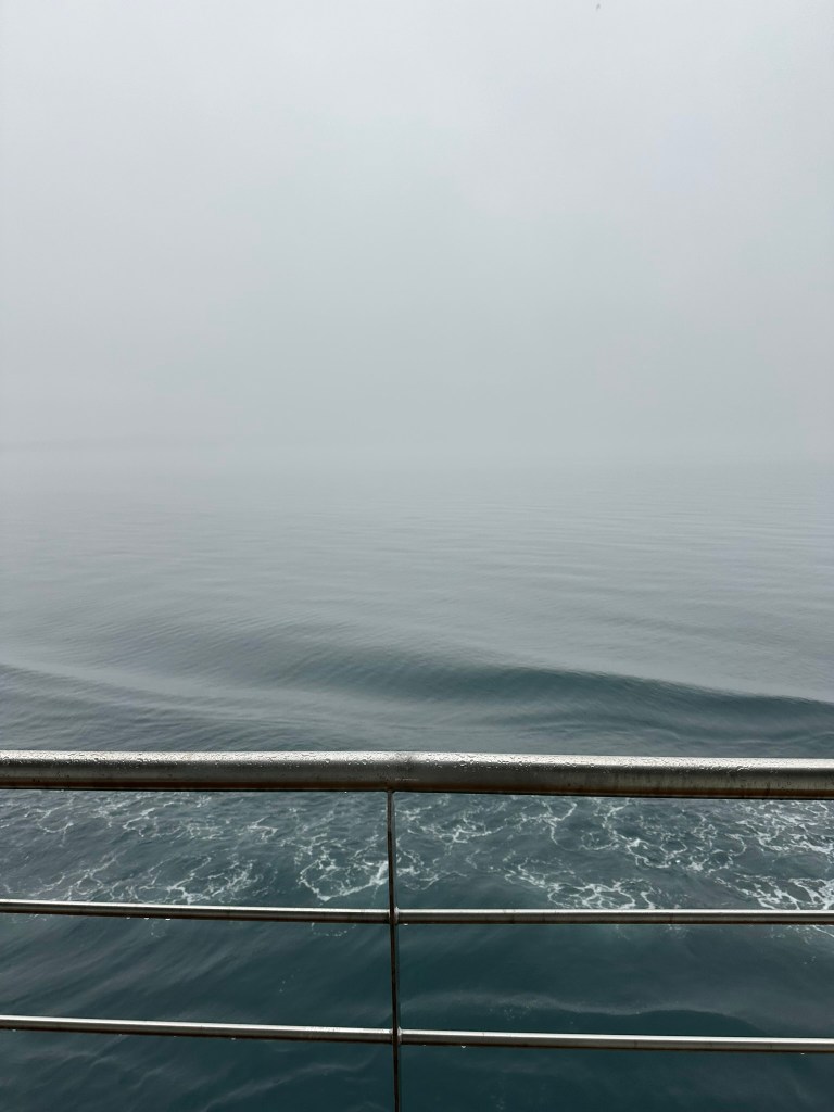
We had had another hour time change the night before so of course I was wide awake way to early again. I did get to enjoy an impressive thunder storm as we sailed towards the town, though we had little to no visibility due to the persistent rain and low cloud.
Nunavut (means Our Land), is Canada’s newest and largest territory, covering more the 1/5th of Canada’s land mass. It is made up of lots of islands and has a population of only 37,000 people. Apparently, there are 25 x more Caribou than there are people in the territory 😂 which is mostly ice cap and arctic tundra. And the area has very little rainfall so it seems that joke is on us, as my hike that had been planned for the day had to be cancelled due to the rain!
85% of the area’s population are indigenous (mostly Inuit) and there are four official languages – English, French, Inuktitut, and Inuinnaqtun. All signs have 4 languages on them and all officials have to speak all four! Interesting the written language for Inuktitut was developed by a missionary for the Cree language and it was adopted by the Inuit’s for the Canadian Inuktitut language.
We were not allowed to take any food off the boat, and, we had been advised not to buy things in the shops here as stocks in the town are very limited, so before departing the ship, we had 2 breakfasts! The first at 6.30am and the second at 9.30am! Unfortunately, it was closer to midday when Canadian entry requirements were finished and we were finally allowed off the ship.
Fun facts, Baffin Island is the 5th largest island in the world, and … Iqaluit has the second highest tide in the world (technically related to the highest tide variation in the world in the Bay of Fundy). A variation from low to high tide of 12 metres!!
The sea was relatively calm for our 3km zodiac ride to the shore but it was raining so we were fully kitted up in wet weather gear including gum boots for the first time. On the shore, we had a wet landing (meaning we had to get off the zodiac into the sea and then wade up) and we then boarded the old Canadian school buses for the tour.
Instead of the hike, I went on a so-called ‘cultural’ tour and the guide on my bus was a French Canadian called Benoit, who has lived in the town for 10 years. He seemed very connected with the area and it’s people despite being a Kablunaat (or foreigner). Now I am going to preface the rest of what I write on this visit to say that Benoit was FULL of stories. Stories that jumped from polar bears swimming to Greenland, to stories of things he has done e.g. cycling through Russia in the winter, teaching local children to ski, building a hut, working as polar bear protection on radar stations etc. I think many of these stories needed to be taken with a little scepticism. True or not, he was incredibly excited and enthusiastic about everything he told us.
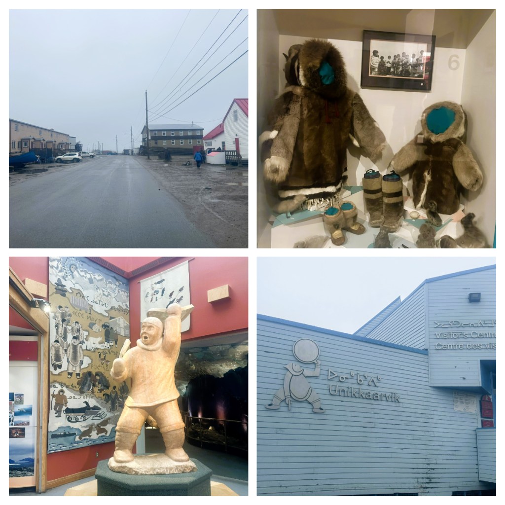
Inuits have lived in this area for over 4,000 years, but the town of Iqaluit started life as a base for the Hudson Bay Trading Company called Frobisher Bay before being expanded by the US during the Second World War as a refuelling station of their planes. It was renamed as Iqaluit in 1987 and despite it being a somewhat modern ‘city’ it doesn’t work! Important infrastructure like roads, water and sewage all break in the weather conditions and permafrost. I can certainly voucher for the quality, or lack there of, of the roads!
Not only does not much work, but it is also very expensive to live here. It costs around C$5,000 a month to rent an apartment so many apartments have multiple families living in them. And not surprisingly, day to day items are 2 or 3 times the price they would be in the rest of the country.
After the war, the Hudson Bay Company moved in to the neighbouring valley of Apex. They were Canada’s biggest company and at that time, they ‘owned’ 75% of the territory. The company was incorporated in England in 1670, and were soon a leading company in the fur trade and this continued for over two centuries. Even in the 20th century they remained one of the largest fur trading and fur merchandising companies in the world and they did not drop out until 1991!. Today, the company still exists as a large conglomerate involved in real estate, merchandising, owners of large department stores and natural resources.
This commerce and development drew the local Inuits, who moved to the town for services such as hospitals, education and of course the hope of work. The population today is around 8,000, and according to Benoit, there are 5 types of people living here: Misinformed, Missionaries, Mercenaries, Misfits and Manhunters 😯. In reality, the Inuits are the more permanent residents, with the rest only normally stay for a few years.
We started our ‘cultural’ tour with a short time to look around the museum and visitors centre. The guys working in the visitors centre were so excited that I was visiting from New Zealand 😀 but unfortunate there is not much I can buy in the way of souvenirs so far as most things are made out of seal fur or reindeer antler which could be problematic when it comes to going home.
The low cloud and constant rain probably did not help with my view of the town, but it was really depressing! Muddy, potholed roads, lots of rubbish in the streets. Apparently, much of the rubbish is brought in by the construction companies, which is then just left behind when they leave! The mayor has started an initiative this year to make the city more beautiful and I do hope they are successful.
It was hard to see much as we drove around the town in the bus as it was still raining and now the bus windows were fogging up due to all the moisture inside (that moisture being us 😂). We did manage to spot St Jude’s Cathedral, built in 1972 and often just referred to as “the Igloo” (due to it’s giant igloo shaped dome) and an Elementary school that looks like a two story ice block!.
We drove out of the town and up to a view point, of course with no view. The site was an old military base, much of which has been removed now and an existing long range radar, one of many that are around the country. The Artic tundra is barren – oh so barren. But, when you took a minute to look at the ground in more detail the small plants and mosses are actually quite colourful.
Back down through the town to a beach, we passed an old Hudson Bay building in what appears now to be the ‘suburb’ of Apex. From here we had to stop at the first traffic light in the Artic to get across a one lane bridge before making our way to Sylvia Grinnell National Park, were we were supposed to have our walk (the rain really had not stopped so probably not a bad thing not to be walking!). We quickly walked up to the viewpoint over the river where a couple of locals were fishing for Char, the main local catch, apparently it is like Salmon but better!
Our final stop was to see the Baffin huskies. Being working dogs, they are not kept in people’s houses, but are all keep in one area on the outskirts of town. Apparently, this breed of dog are strong and not particularly fast but they work well together to pull sleds in the winter.
We headed back to the ship in the mist, just in time to have some afternoon tea. The tour was not my first choice of activities for the day and it was unexpectedly bazaar, but rather wonderful in its oddness 😂. They weather really did not clear all day but the ocean was so calm and looked beautiful through the mist.
Having exhausted myself yesterday, I had a pretty good sleep for an early start for the first day of my expedition cruise. It started with a walk to the Metro station, Metro to the airport and then joining a very long line to check in the charter flight to Kangerlussauq in Greenland. Thankfully, I managed to find a Rep for the company running the trip to confirm I was in the right line! Apparently, the majority of the people on the trip are Danish and I did not hear anyone around me speaking in English – I did second guess myself for a minute and had to double check that I had booked an English speaking trip … thankfully I had!
The ease of my arrival the day before had lulled me into a false sense of security. It took almost 1.5 hours to check in and check in only opened 2 hours before departure! There was then a huge queue for security. Thankfully, as it was a charter flight and the fact that I knew there were others still in the queue behind me, I didn’t panic too much – I was just hoping for time to go to the toilet and get something to eat! Still, I had to run to the gate which was already saying closed (though I did manage to get a cold coffee from a vending machine) before boarding the plane.
I also didn’t need to worry so much about hand luggage weight (the predeparture paperwork said you could only take 5kg for hand luggage) as they did not even weigh it! Once I got on the plane and saw how much hand luggage some others had, I really had nothing to worry about! If they had weighed them, we would never have got off the ground 🤣. As it was, we were only 45 minutes late taking off.
Boarding the plane also just confirmed my initial view that everyone on this trip are OLD! Does that mean I am old 🤔 I don’t think so 🤪. In fact, I think I drag the average age down by at least 10 years! I later found out that the company had run a big marketing campaign in a newsletter for an old peoples society in Denmark – it clearly was effective as I would say probably 85% of passengers were Danish people over 65!
To me, Greenland has always been a mythical place. When I made my first trip to England at the age of 8, my mum woke me on the flight between the UK and the USA to see the wonderful sight of the vast, ice covered island. It became a place you fly over and admired from 38,000 feet above if the weather is in your favour. So I was excited to get my first glimpse of Greenland – icebergs in the ocean, glaciers flowing down and snow/ice as far at the eye can see. Just 🤩.
The cloud cover them rolled in until we came out on the western side of the country, now with the view of braided rivers and bright blue glacial lakes – just like home 🤣. I hadn’t even got off the plane and the unique beauty of the landscape was blowing my mind.
Before I get too far in to the trip, let me regal you with a few facts about Greenland. Greenland is the world’s largest island at just over 2 million km2 and with a population of just over 56,000 makes it the least densely populated country in the world, although probably not technically a country as it is a self-governing autonomous territory of the King of Denmark. 80% of the island is covered in the Greenland ice sheet and what remains is pristine Artic tundra , where the subsoil is permafrost (i.e. permanently frozen) which causes challenges in many ways which I am sure I will touch on in future blogs.
There are only 20 towns in Greenland, 7 of which have populations of less than 1,000 and as there are no roads between towns, you can only travel between them by boat, airplane or helicopter, depending on where you want to go!
We touched down in Kangerlussuaq in the west of Greenland and despite this currently being the main airport in Greenland there were no arrival formalities. The airport appears to be home to a couple of Hercules and an odd NASA plane called POLAR 6, that has equipment to take photos through the ice cap. We went straight from the plane to a bus for a pre-booked excursion which I had complete forgotten about, I couldn’t even remember what it was 🤣.
Kangerlussuaq is the current gateway to Greenland and the airport and town was built by the Americans as a stopover point for the American Airforce during the Second World War due to the stable weather in the area. At that time, the town had a population of thousands (mostly American). In the 1970’s, the town was sold to the Danish Government for US$1, as is where is, and today the town has a population of around 550 people most of whom are involved in work at the airport. There is currently a new airport being built in Nuuk (the capital) and once that opens, the future of Kangerlussuaq is uncertain.
Despite being advertised as an English cruise, it seems my fears of all the Danes at check in was coming true as the initial commentary in our bus was in Danish. Thankfully there were some German’s on my bus who spoke up and asked that they also speak in English. We had to remind the again when we reached the BBQ spot as all the information was given in Danish! I hope this is not a ongoing issue!
The BBQ spot was on the shore of Lake Ferguson, where the town gets its fresh water and it was clearly the only place that caters for all the cruises that pass through to pick up passengers as there was a group waiting for pick up when we arrived and another group dropped off as we were finished. That said, they are good at what they do and the BBQ lunch was tasty and consisted of lots of meats and salads, including musk ox (tastes like beef) and reindeer sausages (which tasted like sausages 😝).
This was also my first taste of the Greenlandic mosquitos or maybe they were midgets or whatever the little bitey buggers they were. Of course, all my anti mosquito stuff was in my backpack on its way to the ship!
After a discussion with a couple of the Germans, I suggested to one of the guides that they make one of the buses English speaking so we don’t miss out like some did on the way up. I am not sure why I need to be making these suggestions as I would have thought they could have worked that out for themselves and yes, it seems like I am going to be THAT passenger 😂 as I am not prepared to miss out on information. As it turns out, they probably didn’t think about having one bus in English as they were too busy working out why a group that came up in 3 buses could now not fit in the 2 buses they had 🤔 . Finally, a 3rd bus turned up and we drove back through the town, into the low cloud and rain. Thankfully it was a balmy 9C – apparently it had been a fairly cool summer this year!
For this part of the trip our driver was a Greenlandic guy called Adam. Whilst driving the large, all terrain bus on the narrow, windy dirt roads with one hand, he held a microphone with the other hand and gave us commentary. Although it was in English, I really only managed to catch snippets of what he said. Some of what I did pick up (I think) is detailed below.
Naturally, Artic tundra tends to be treeless due to the underlying permafrost, but in this area they have been experimenting with planting trees from other countries in the area, including New Zealand. I must admit, some of the area was reminiscent of our sub Alpine and Alpine areas in New Zealand.
Musk Ox were introduced here from the eastern side of the country. They have thrived here as they are much better suited to the less snowy conditions of this area as they cannot walk in deep snow. The current musk ox population of over 30,000 all come from 27 introduced animals. Reindeer on the other hand thrive everywhere and have hooves designed to spread out like snow shoes. Both are hunted and often the hunters bury the bodies in the permafrost to keep until they need them.
As I mentioned above, there are no roads between towns and cities, and so, the road we were driving on is the longest road in Greenland at a staggering 50kms long! It’s dirt and basically only 1 lane! It took us through the almost ‘green’ landscapes to the UNESCO World Heritage area of Aasivissuit-Nipisat, a cultural landscape that is the traditional hunting ground of the local Inuit.
From here we could see across to what remains of the retreating Reindeer Glacier (no reindeers in sight). The landscapes on the drive were amazing, but please do excuse the crappy photos taken through the rain streaked windows of the bus! Apparently from next year, this area will become a National Park.
The Glacier was impressive despite the rain but we only had around 15 minutes there as it was already 4pm and we had to head back down the longest road in the country, in to a zodiac and out to the ship, moored in the fjord, just beyond the town.
Now, things got really good … Firstly, I recognised one of the guides from my Indonesian trip a couple of years ago and it was nice to see some I knew in the sea of non-English speaking faces. Secondly, my old waterproof pants passed the waterproof test after a rogue wave swept over the side of the zodiac on the way out to the ship and last but not least, I had my room to myself! When booking, I had the option to a have small single room with a window, or for the same price, share a larger room with a balcony. I had gone with the later, but as it turns out I got this amazing room all to myself – this really made my day and you can look forward to many balcony view photos 😂. This is by far the nicest expedition cruise ship I have been on!
We only had time for a short briefing and emergency drill before a buffet dinner and bed as we set sail into the mist.
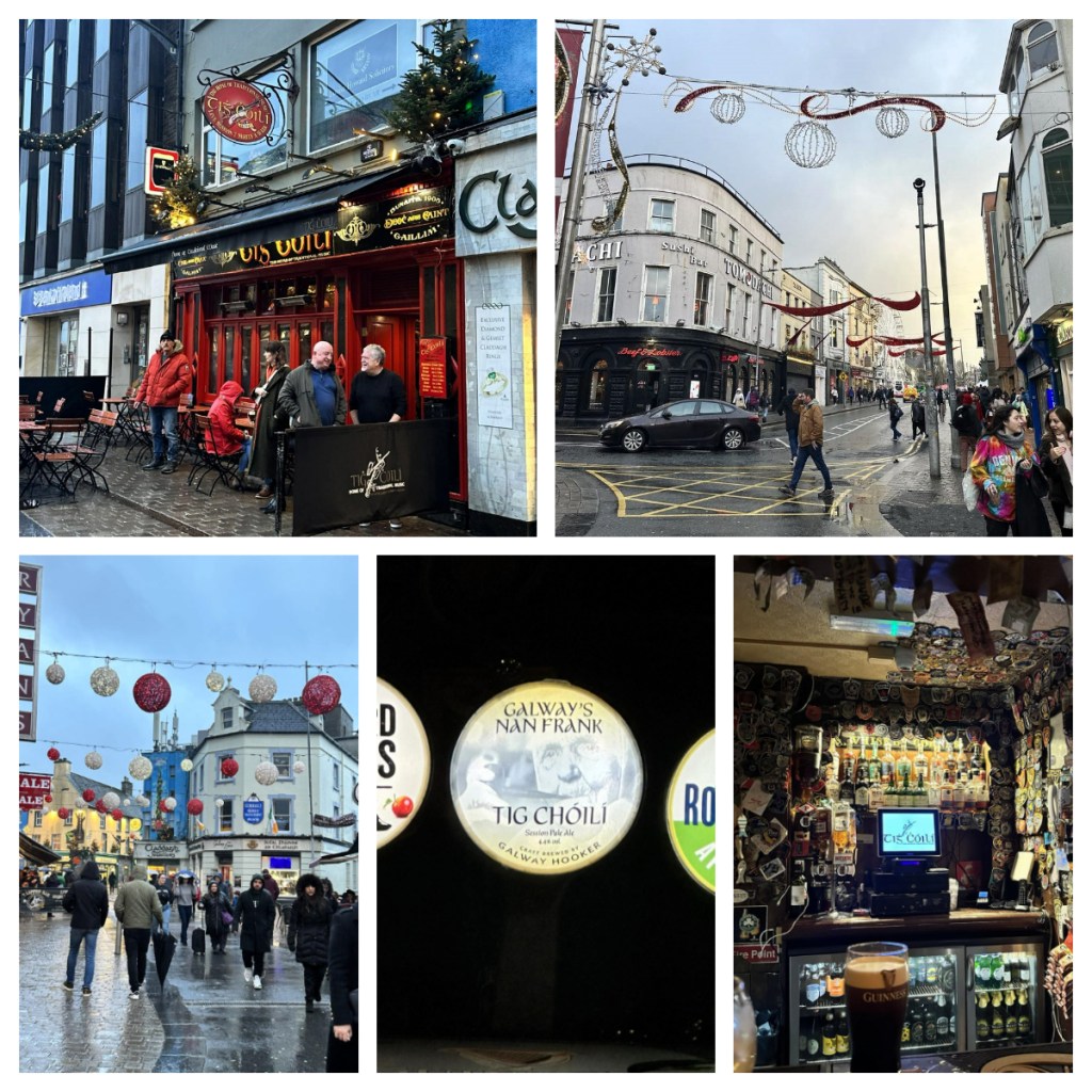
After a full Irish breakfast (pretty similar to a full English breakfast but perhaps with Irish Soda bread) I met up with my friend Suzanne to drive from Dublin in the east to Galway in the west – a nice 3 hour drive through the countryside.
Galway grew up around a fortification built in 1124, today, despite being the 4th largest city in the Republic of Ireland, Galway only has a population of around 86,000. It is a very popular tourist destination due to its strong artistic and musical traditions, its lively atmosphere, great food and nearby dramatic landscapes.
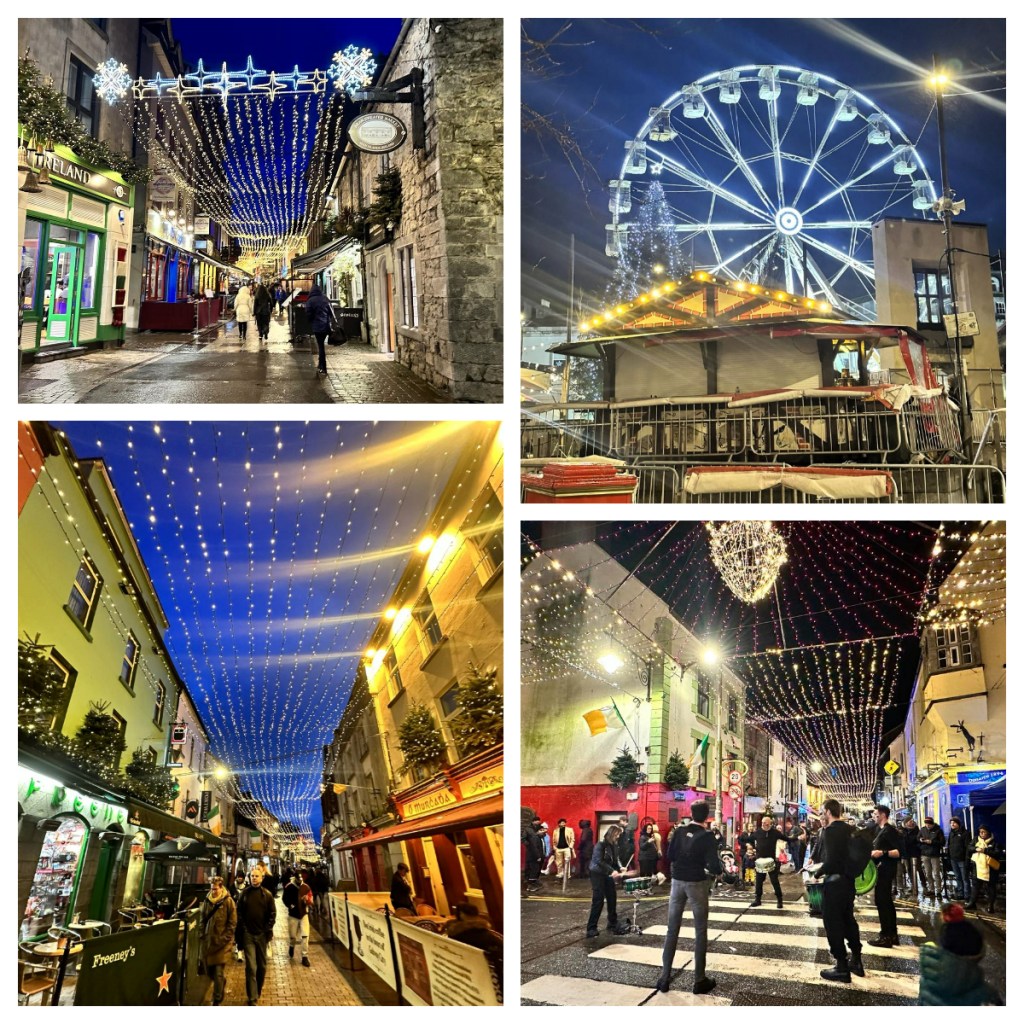
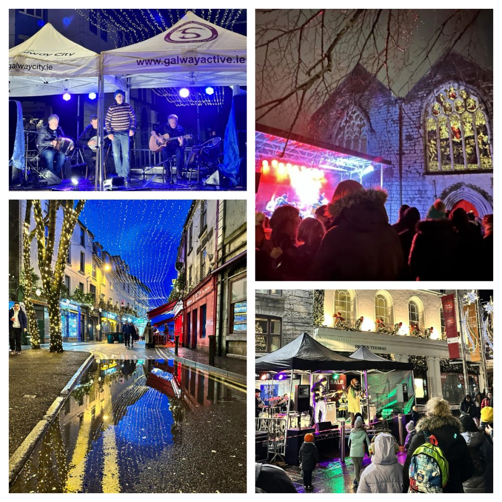
By the time we had arrived it was already midafternoon, so after checking to our hotel we headed out for something to eat. There was a small Christmas fair in the central square and lots of beautiful Christmas lights around small old town and the light rain was not going to put us off exploring – in fact it was a great excuse to check out Tig Choili. Touted as the home of traditional music it did not disappoint as they had a live trad music session going on as we arrived. The small bar was packed with people and atmosphere.
As it started to get dark, the lights came on and the puddles were filled with reflections (we all know I love a good reflection) and, as it was New Years Eve (did I mention it was New Years Eve?) there was a programme of buskers set up around the old town. We spent time wandering around the different stages enjoying the music – ranging from drumming, soul to trad. (If you are on Instagram, check out the reel I did about the evening). It was a great event.
We headed back to the hotel to get changed and before going back out to Monroes, a popular live music venue who were hosting Kíla, a popular Irish folk music group. We had planned to stay here till midnight, but a friend of Suzanne’s who lived on the nearby Aran Islands was in town as asked us to join him at a small French restaurant across the road. We did and it was fabulous – they were obviously hosting a 1920’s themed New Years eve dinner and we sat on the side, enjoying champagne and singing around the piano. It was a great way to top of the evening and ring in the new year.
The hotel breakfast the next morning included another full Irish (it would be rude not to) before we decided to walk the 3km out to the Salthill Promenade. Unfortunately, the rain really got us this time, setting in about 10 minutes into our walk … but we preserved and fully made it out to meet up with some other friends of Suzanne’s who were out here for a traditional New Years Day swim!! Ah, these Irish are a funny lot lol.
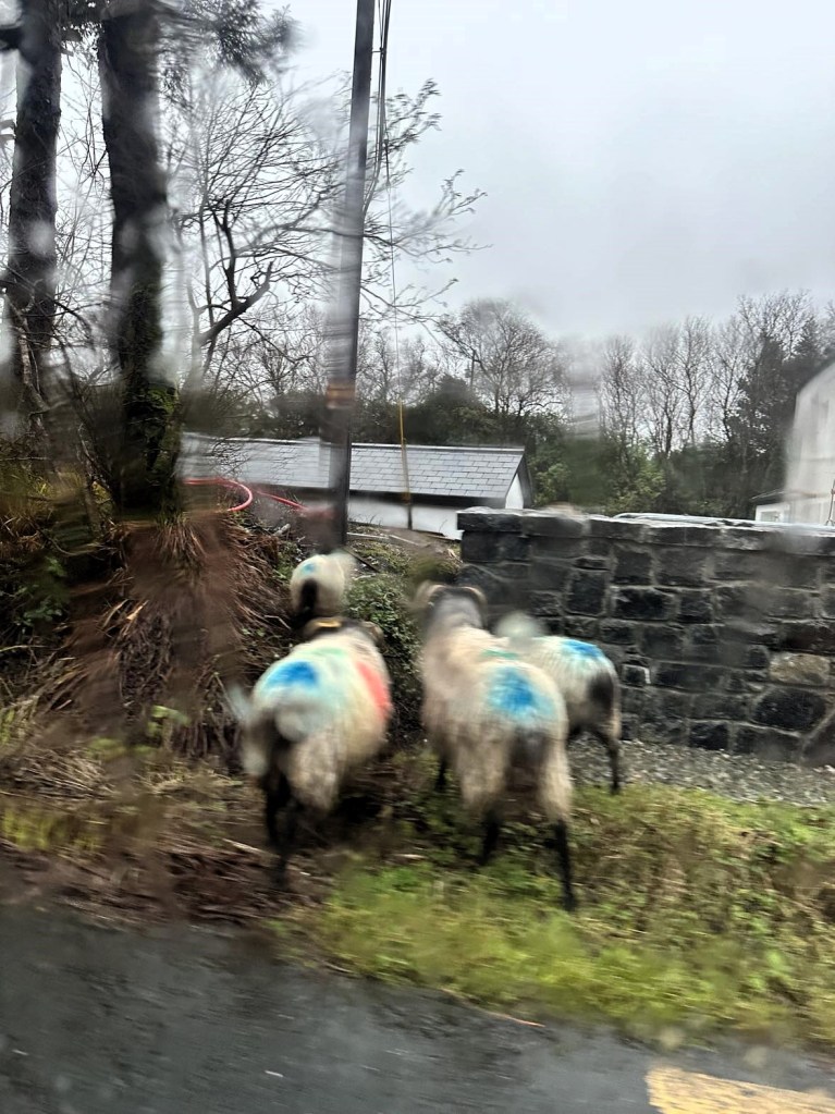
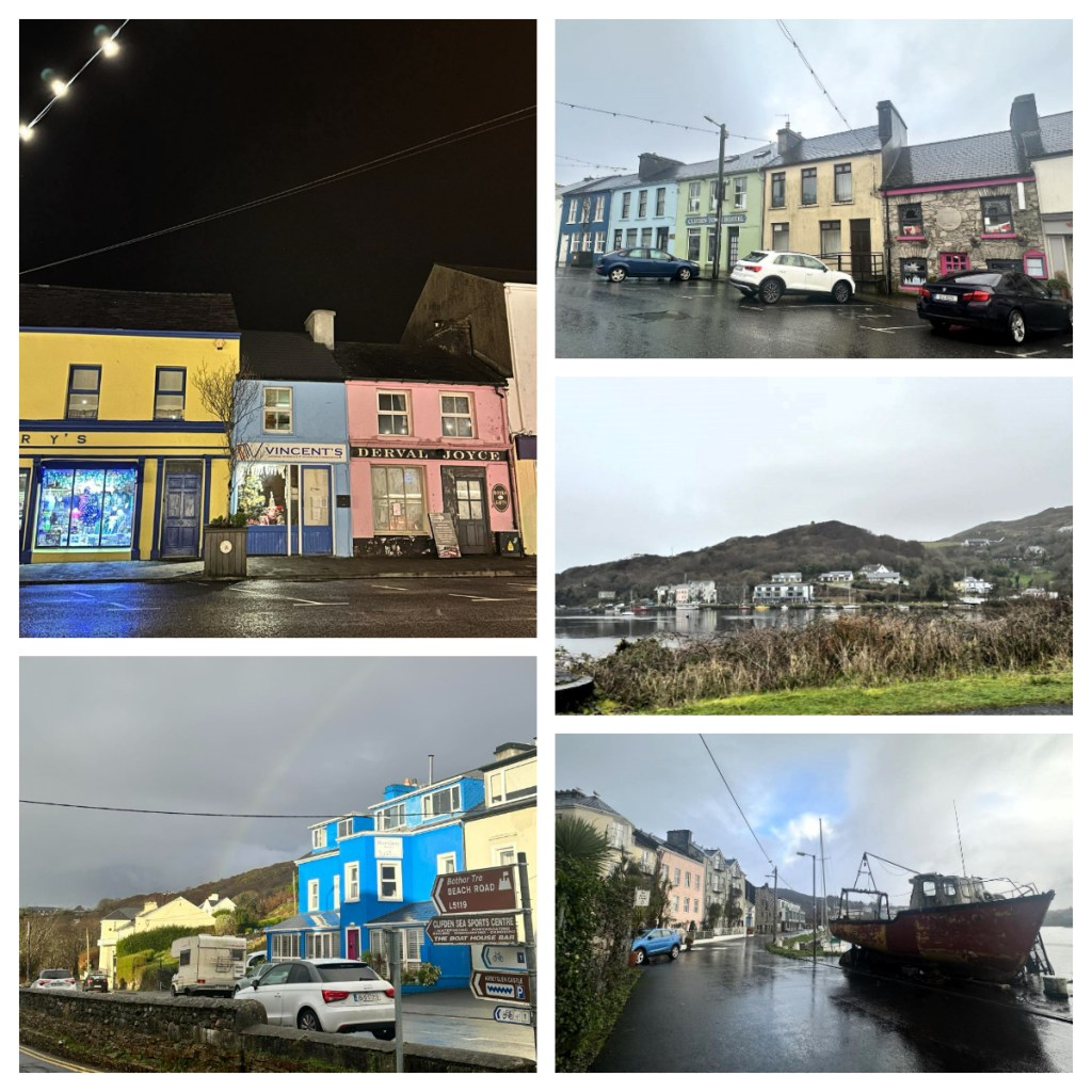
After a chat over coffee, it was time to hit the road again, this time to Clifden, the so-called capital of County Connemara. The morning rain continued as we drove the 1 hour 20 minute drive through some surface flooding and sheep on the road – made me feel right at home lol.
Despite its size (population around 2,500) it is the economic capital of the area and is the base for some of the best sites around this part of the west coast. After a lovely dinner and a couple of drinks, we settled for an early night.
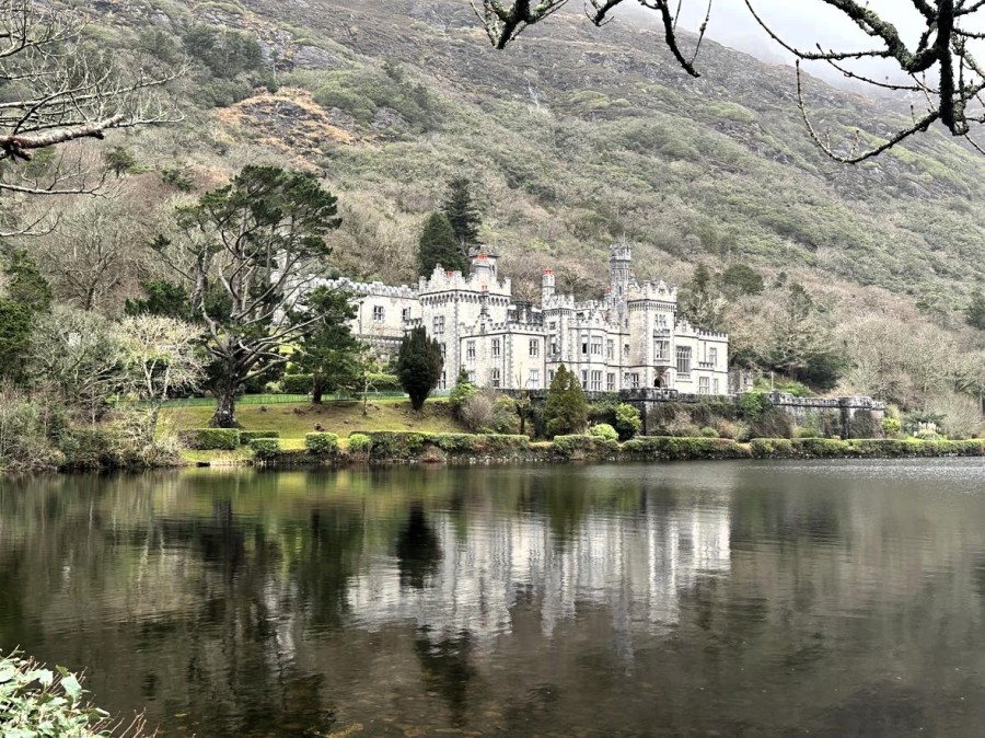
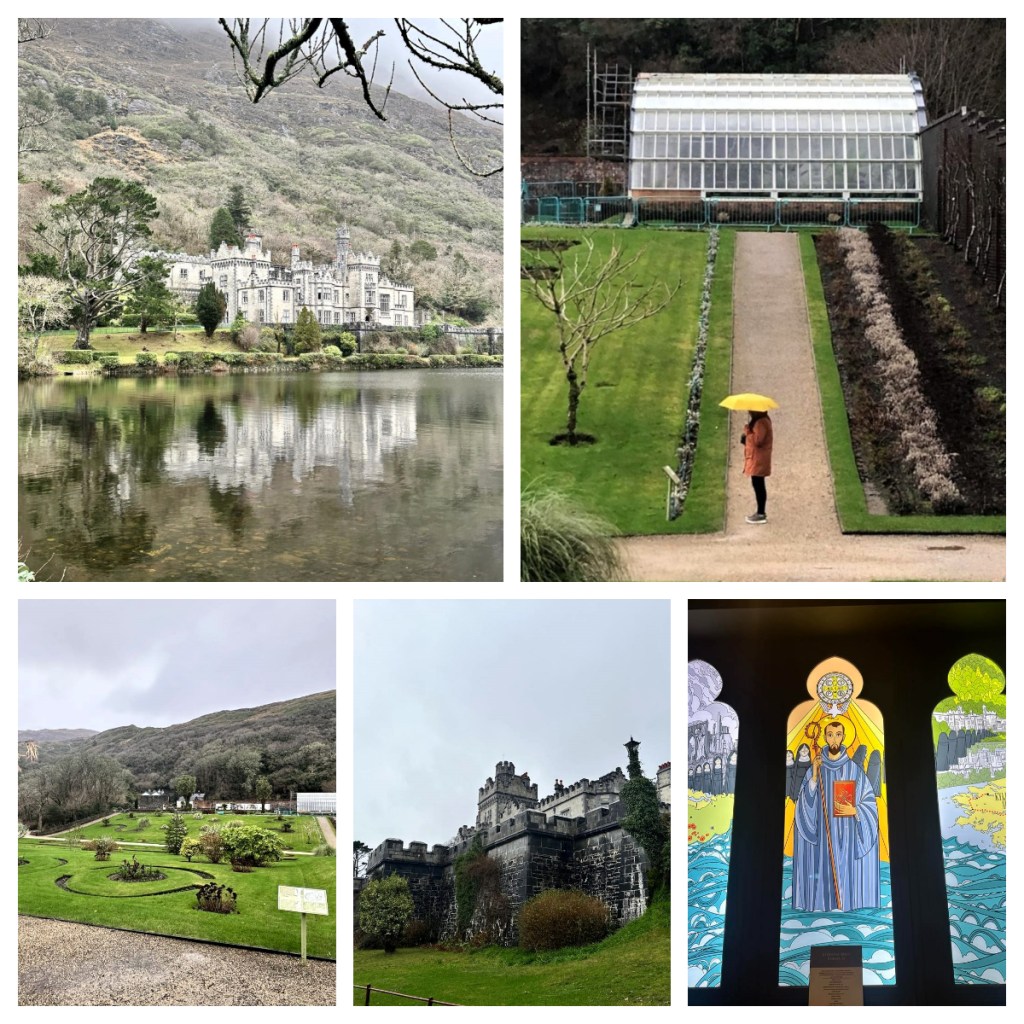
January 2nd, we set out to explore the area. It was still overcast with a little rain, but we were not going to let us stop us. First stop was the beautiful Kylemore Castle. We were lucky enough to have a break in the weather and managed to get a moody version of that icon reflection view but decided to start in the Victorian walled garden as we were unsure how long the weather would hold!
But first some history … Mitchell Henry, a wealthy doctor from London, built Kylemore Castle in 1868 for his wife Margaret after they feel in love with the area on their honeymoon in the 1840s. The castle took 100 men 4 years to build and had 33 bedrooms, 4 bathrooms (which is a crazy ratio in today’s world), 4 sitting rooms, a ball room and of course rooms for all the servants.
When his beloved Margaret died in 1874 (of a fever she contracted in Egypt), Mitchell spent less and less time at Kylemore. He did however build a Gothic chapel and mausoleum which holds the bodies of Margaret and Mitchell.
In 1903 the estate was sold to the Duke and Duchess of Manchester who lived there for a few years before having to sell it to repay gambling debts!!
In 1920 the site was purchased by Irish Benedictine nuns after they had to flee their original location of Ypres in Belgium because of the war. They ran a farm on the site and opened a school in 1923 which attracted the children of nobility from around the world as boarders (including an Indian princess and even Madonna tried to get her daughter in) and local girls as day students (for whom it is free). Sadly, the school was forced to close in 2010 due to lack of students.
Back to our visit … we caught the shuttle bus the short distance to the gardens and enjoyed a strolled around it, learning abouts its history from its informative panels. The 6 acre garden was created along with the castle in the late 1800s. In its heyday, it had 21 glasshouses and 40 gardeners!!
After many years of neglect, the nuns brought the gardens back to life and feed the nuns and the students from the school from the produce grown here, but it was not until 1995 when a group of historical restoration consultants, garden archaeologists and architects were brought together to bring the gardens back to their former glory.
After a short walk around the gardens, we caught the shuttle bus back to the reception area and took a short walk to the castle to join a history tour. Our guide was so enthusiastic about the castle and it’s story, and it was fascinating learning more about the castle in a more personal way.
We learnt about the fantasy fairytale exterior design and all the modern trappings it was built with inside including electric lights, gas heating and indoor plumbing. In fact, it was one of the first private homes to have self-sufficient electricity from an onsite hydroelectric turbine.
Kylemore was great, but we had more to see before it got dark, so we moved on for a brief lunch stop in Letterfrack, a village founded by the Quakers in the mid-19th century, before continuing down narrow country lanes, through beautiful moody landscapes to Claddaghduff, the ‘jumping’ off point to reach the tidal island of Omey Island. The island is said to have been one of the last lingering strongholds for pagans, before the monastery, Feichin’s Church was built in the 7th century. Subsequently it has supported some successful farms over the years. Currently, the population is listed as 5!
At low tide, you can walk across the sand to the island, and in fact you can even drive! Despite being there at low tide, there was still a few fairly wet spots and although my shoes were waterproof, I didn’t want them covered in saltwater so decided to wander around the foreshore while Suzanne went over to the island to explore. My choice did not disappoint as I enjoyed just strolling around the beautiful wild beach and was awarded by a stunning rainbow. 🌈
Back in Clifden, now the New Year rush is over, many of the bars, restaurants and even hotels were closing up until February or March. Thankfully we had one more night to have a couple of drinks in a couple of the local pubs, ending up in the bar by the hotel where there was live music and then to the hotel lobby where there was a piano player – actually the same guy who was playing the piano in the bar we ended up in on New Year’s Eve – small world lol.
On our final morning away, Suzanne was not feeling well, so I got up and despite the rain, I headed out for a morning walk through the town and down to the waterfront. Clifden is not a big town, but it was nice to stretch the legs before we headed back to Dublin, via a quick stop at Ireland’s oldest pub – Sean’s Bar in Athlone. Established in 900AD! I admit I do love the Irish pub atmosphere – dark, cosy, warm fire – nothing like it in the winter.
As well as Suzanne starting not to feel well, Ania, who I was supposed to stay with back in Dublin, tested positive for covid (Covid – disrupting plans since 2020)! Despite feeling sick, Suzanne kindly offered a bed in her place for the night and it definitely an early night all around!
Next morning I headed just around the corner to the airport bus stop. It only ran from this area every 2 hours, so I went super early. It was a lovely morning for my last trip through the city and I was lucky enough to get an earlier flight to London for my last couple of nights.
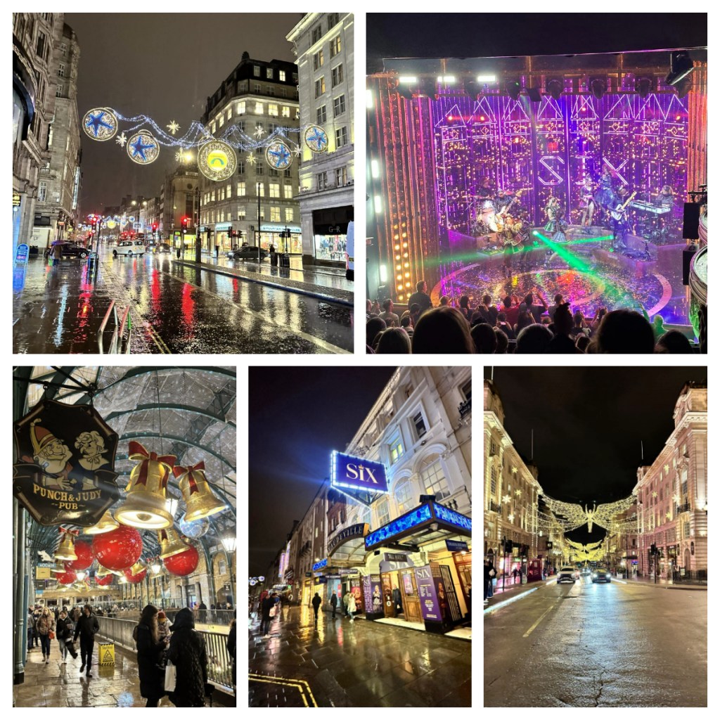
I caught the tube into the city to my hotel in Piccadilly – it was called a cocoon room, and it was true to its name in size, but it was clean, comfortable and in a great location, so I was happy. By this point I felt like I was fighting to keep those Irish germs at bay and as the day went on, it became clear I was losing the battle. After a quick nap I managed to head out in the torrential rain to see the Christmas lights, enjoy a bite at Pizza Express (an old favourite) and see Six – The Musical. The musical was great fun and despite not feeling the best, the evening reminded me just how much I love London.
The next morning, I managed to make it out for a walk around some of the central tourist attractions – around Trafalgar Square and down Pall Mall, just in time to catch the procession for the changing of the guard. It was incredible to see how many people come to watch the regular event. Just a great bit of English pomp and ceremony.
In the afternoon I made my way out to the west of the city to visit an old friend and it was wonderful to catch up her, but I did have to have an early night and sadly felt even worse the next morning. All final day activities were cancelled due to this unwanted Irish souvenir, and I had to book a day room in hotel at airport were I basically slept all day, until it was time to head to the airport for my flights home.
Despite the Irish germs, it was a great trip exploring new places and catching up with friends.
After another great night’s sleep, I left Belfast and drove south, back across the invisible border to the Republic of Ireland – there was not sign indicating the border on this road either!
My destination the Boyne Valley in County Meath and the World Heritage Site of Brú na Bóinne. Until I started researching for this trip, I was completely unaware of the Neolithic history of Ireland and that there are various stone age sites that you can visit – Newgrange being touted as “the jewel in the crown of Ireland’s Ancient East”. Created around 5,200 years ago (3,200BC), it is older than Stonehenge, the Egyptian Pyramids at Giza and even the ancient city of Petra in Jordan!! This blows my mind!
To visit Newgrange, the most well know of the passage tombs in the complex, you must start at the Brú na Bóinne Visitor Centre. It was a cold day and the visitor’s centre was fairly quiet but given the staffing levels I assume they have much busier days/moments – there were 3 people within about 10 metres of each other, first to check my booking, the second to give me my ticket, and a third to check the ticket I was just given (in front of them) 🤔😂. I have not seen such a great job creation scheme since the small shops in Japan!
Your visit to the site includes a bus from the visitor’s centre to the site itself and as you enter you are allocated to a specific bus time. I had around 30 minutes to explore the really interesting exhibits and information. Apparently, the Boyne area has many Neolithic sites which date back to the “new stone age” era when humans started farming and living in settled groups. For them, Brú na Bóinne was a sacred place.
From the visitors centre, it was around a 5 minute walk across the River Boyne to the bus stop where I joined a group of people on the bus to the site itself. A short ride down narrow country lanes and we got our first glimpse of the passage tomb of Newgrange.
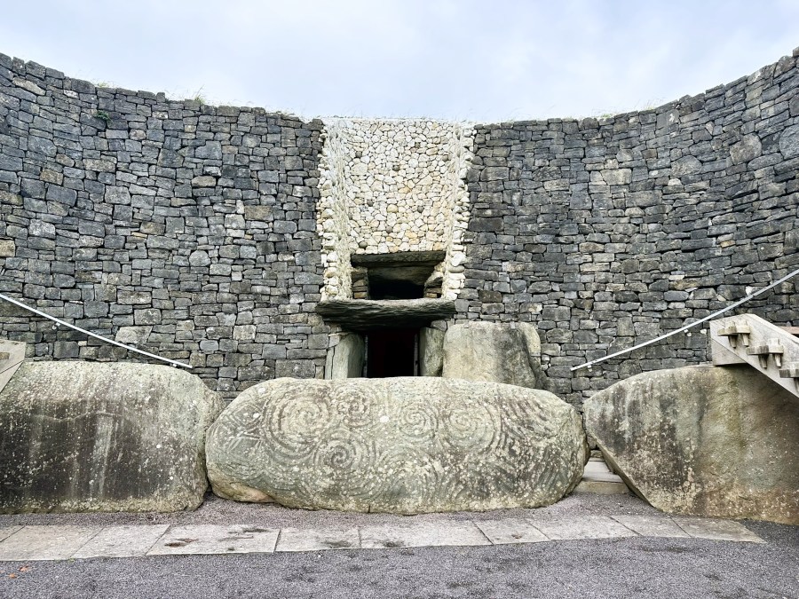
It is understood that passage tombs were used to contain the remains of the dead and it is likely that they were actually built over the bodies, rather than the bodies placed in afterwards. However, Newgrange is considered to be more than just a passage tomb and is considered more likely an Ancient Temple with astrological, spiritual and ceremonial importance. In fact, this site has amazing examples of megalithic art on a scale not found anywhere else in the world!
We had time to wander around the mound, around 85m in diameter and 13m high (covering a total of around 1 acre) before meeting the guide for our time inside the tomb. Unfortunately you could not take photos inside the tomb, which is a shame as the engineering that went in to the building of the tomb was amazing, as were the unique artworks.
One of the most special things about the site, is that on the winter solstice, the passage and burial chamber are lit with the sun as it rises. As we stood in the passage, which these days is lit with electrical lights, the guide turned off the lights and recreated the moment of the sun rising on the winter solstice. As with other ancient wonders like the pryamids of Giza and those in the South American Mayan world, the astronomical knowledge of the architects, engineers and astronomers who built them is incredible.
It was a really interesting visit and the countryside was beautiful despite the freezing weather, I was just grateful it wasn’t raining.
From Brú na Bóinne it was only a short drive (down more narrow country lanes) to Slane where I was to spend the night. I was a little early to check in to my accommodation so headed first to the Hill of Slane.
Legend has it, in 433, St Patrick lit a fire on the hill, in defiance of the law of pagan High King Laoire, who forbade the lighting of any fire before his fire, on the nearby Hill Of Tara, was lit on the spring equinox. Despite being angry, the King was impressed by St Patrick’s devotion, he allowed him to continue his missionary work which brought Christianity to Ireland (basically putting the putting King out of a job)!
The hill is only 158m high and from the carpark it was just a short walk to the top which today houses the ruins of a Franciscan Monastery dating back to 1512 as well as those of a college built to house four priests. From the ruins, there were also beautiful views out over the countryside.
From the hill I headed back in to the small village of Slane (population around 1,500) for lunch at the Village Inn and a quick visit to the nearby 18th century castle. It was unfortunately closed so could only admire it from the outside, but I did pop in to it’s neighbouring whiskey distillery to do a little souvenir shopping before I made my way to my AirBnB.
I had thought about heading to the pub later for some dinner but it was so cold and the Airbnb was so cozy I just stayed in!
When I headed out at 8am the next morning it was dark and raining but I had to set off to the airport to drop off my rental car. I had been fortunate so far in avoiding the worst of the rain but not so this morning.
From the airport I took the bus back to city and headed back to the same hostel I had been in before Christmas. The hostel was ok and conveniently located and I had decided it was easier to go with the familiar rather than have to find my way to another place. This time I had splashed out and booked myself a single, private room and luckily enough it was ready for me to check in to early. Please note – a private room in a hostel = a room about the size of a shoe box but at least it was clean and I had my own bathroom.
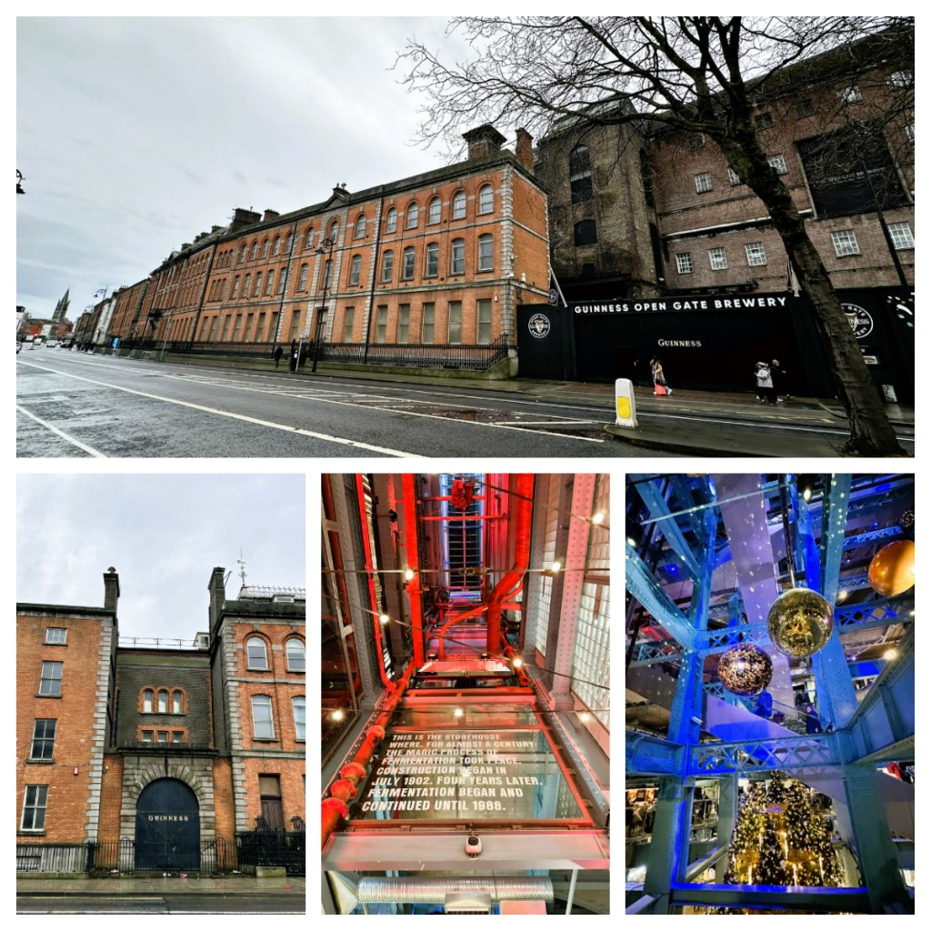
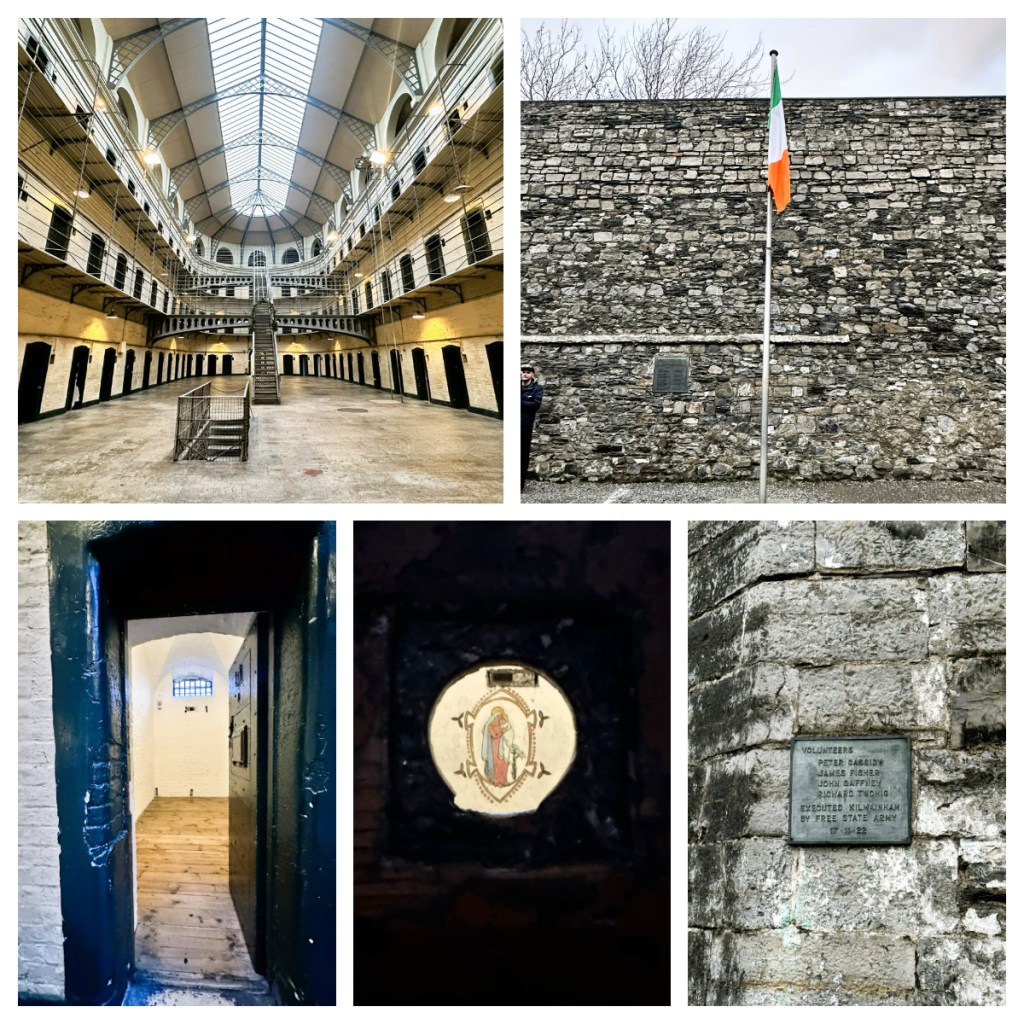
With no time to rest, I dropped my bags and headed straight out. First to see the Jameson distillery. Not being a whiskey drinker myself, I didn’t go in, but wanted to see it and make a few small purchases for gifts .. and it was kind of on my way … to the Guinness storehouse. I am also not a big Guinness drinker but I like it more than whiskey so thought I should visit!
The Guiness store house is a huge imposing building taking up a whole block and let’s be honest, you must be living under a rock if you were not familiar with the iconic Irish beer which can be found all over the world.
Arthur Guinness started brewing on this site over 250 years and in 1759, he had the foresight to sign a 9,000 year lease on this St James’s Gate Brewery! Now that shows true commitment to his product! The Guinness family today continue not only the brewing legacy but also the philanthropic one, supporting and donating to various charities, historic building restorations and underprivileged communities and as well as maintaining a high level of employee welfare.
As you worked your way up the levels (7 levels in total), you explored the history of Guinness and how they make it – from grain to glass. To be honest, although it was interesting, there were a few too many people in some areas so I did not spend much time waiting around to read all the information panels and wasn’t that fussed with the place … until I reached the sterile “tasting room”. It was completely white and sterile and when the room was full, they closed the door! It had areas where you could enjoy the aromas of different parts of the beer and were each given a shot of Guiness. I now actually started to feel like I was in the beer version of Willy Wonka’s chocolate factory – so many different floors and rooms!
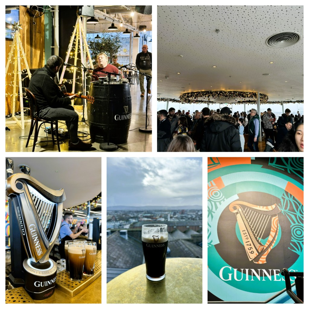
From here we moved I to the Velvet room (I think that was its name) for a brief talk about how to drink Guiness. This room was filled with paintings of Guinness’s past and information about their contributions. Instructions were given … “Pause and smell the aromas before taking a big slug lol. Don’t sip just the creamy white head as that is for texture rather than taste”. I must admit – I actually enjoyed it. Perhaps I have always been drinking it wrong.
The final stop was for a free pint of Guinness (well, it is included in the entrance price) in the circular Gravity bar, one of Dublin’s most unique roof top bar, with a great view over the city. I was very lucky to get a seat after only a short time so could properly enjoy the view and my pint.
I then headed down a couple of levels to one of the numerous restaurants for a Steak and Guinness pie (it had to be done) and to enjoy the magically Christmas decorations around the 7 story central core and the traditional music and dancing on show. It was a perfect end to my visit.
After an enjoyable couple of hours, I headed back out in to the cold for a 30 minute walk through a more gritty suburban part of the city. (Turns out I could have walked through the lovely gardens of the museum of modern art, rather than the grungy back streets but thanks to google maps for keeping it real 🥴😂.)
My friends had told me that Kilmainham Gaol as a must see in Dublin and that bookings were hard to come by so I had scheduled a reminder to book as soon as they began available (a month before the visit date) to make sure I got a ticket.
Since it was opened in 1796 as the Dublin County Gaol, until it was closed in 1924, thousands of men, women and children were held Kilmainham Gaol for offences that ranged from owing money or begging to political prisoners involved in the many Irish uprisings – from the 1798 rebellion, the 1916 Easter Rising, the Anglo-Irish war of 1919-1921 and the Irish Civil War in 1922/23. When the prison closed, the initial consensus was to tear it down as it held many bad memories, but in the 1960’s, a group of revolutionary veterans decided to preserve it as a national monument rather than tear it down so they can share the stories that are a huge part of Ireland’s history.
As if closing the loop, in 1966 the new museum was opened by the President of the day, Éamon de Valera. He had been one of the last prisoners released in 1924!
Our guide took us from the Court House, through what was a catholic chapel before we moved in to the earliest part of the prison – cells built for reform, based on the concept of “silence, supervision and separation” however the in the early days, the overcrowded prison did not allow for any reform or separation, with men, women and children all crammed in together in small cells with no heating (gas heating was not installed until 1890s.
There was supposed to be 1 person per cell and in the holding cells for those going to Australia, there could be up to 3 per cell … and their waiting time did not count as part of their sentence. Some inmates were as young as 10 or 11. In fact, the youngest prisoner was 3 year old Thomas Roberts who in 1856 he was imprisoned for begging. Sadly there is no record as to what happened to him when he left. During the famine there were up to 5 per cell as people were trying to get in to prison to get food!
As we moved through the prison, from the oldest sections to newer areas, some of the cells showed the names of men and women who were help in them. Many of the leaders of the unsuccessful rebellions against the British were held here – some were even executed on the grounds whilst others were released and went on to be part of future governments. Most of these leaders were not military men (and in some cases women), they were teachers, artists and poets.
The most recent wing of the prison was much improved from those earlier areas. Built in 1861 in the panoctogan style, known as the all seeing eye – a guard can stand on the central platform and see everything. It also considers that light is key for reformation and the glass room givens plenty of light.
The tour ended in the execution yard, perhaps one of the most important sites in Irish history. The site of a number of brutal executions, including public hangings. The British started to lose support from many of the Irish citizens due these executions of politic prisoners and the treatment of the bodies after execution – in some instances they refused to give the bodies back to the families. Who knows what they were hiding.
It’s new life as a national monument also finds it popular as a location for movies, appearing in films such as the Italian Job, Michael Collins, In the name of the Father and even Paddington 2.
As I exited the prisoner I spotted the start of a beautiful sunset and I couldn’t resist taking a walk through the gardens of the museum of modern art before finding a bus back to my hostel, just in time to freshen up and change before fun night around Temple Bar with my friend Ania.
It was really busy and lots of tourists but fun never the less. I had been warned that the bars in Temple Bar are costly and they were not kidding!! A pint of Heineken and a gin and tonic cost euro 26 – $45 – I am not sure where in NZ you would pay that much! Let’s consider the budget well and truly blown 🥴 That said, it was a perfect day to finish off my time in Dublin.
Awaking refreshed from a very comfortable night’s sleep and not a single regret about my room upgrade lol. I had two main things booked for the day – visit the Titanic Museum in the morning, and a Black Cab politic tour in the afternoon. As I was now staying centrally, I took the opportunity to wander around first thing. There is not much commentary to photos I took as I wandered, I just took photos of things I liked the look of and planned to find out more about the locations later!
I came across City Hall which was beautifully decorated for Christmas. I wish I had explored a little more last night as I arrived just as they were in the process of dismantling the Christmas market in front of it (which had finished before Xmas) and taking down all the decorations. So I got some lovely photos with lots of trucks in the pictures 🥴.
I paused for a hot chocolate at the large indoor Victoria Centre (a shopping centre) before continuing my wandering in the general direction of my first stop. This took me across the river Lagan on to the Titanic Trail. There were lots of very informative signs about historical Belfast and its ship building industry and I even spotted a couple of “city” seals in the river 😂.
When I arrived at the museum there were a lot of people gathered outside. Thinking it was not open yet, I took the opportunity to explore the outside area and the Olympic slipway where the Titanic was “born”. In fact, it was actually security alert that had evacuated the building 🤦🏻♀️. Thankfully I did not have to wait long before we were allowed in as it was bitterly cold.
I had prebooked online which meant I could walk straight in and that I also got an audio guide. Although it was not really necessary as there was plenty of good information around the museum, I enjoyed listening rather than having to try a read the sometimes crowded signs.
The museum covered the history of the city including key trades such as linen, rope making, tobacco and ship building. At one time, Belfast had the largest ship yard and glass blowing manufacturers in the world!
After going though the original gates from the Harland and Wolff shipyards we joined a short ride through a re-creation of the shipyards of the time to experience the heat and noise the workers had to endure. Incredibly, the Titanic had more than 3 million rivets in it, most of which were put in by hand!
Now, I am pretty sure everyone knows the story of the Titanic. Launched in Belfast in 1912, it was the largest ship afloat at the time she was launched by the White Star Line. Her inaugural journey was to take her from Southampton in England to New York with some of the wealthiest people of the time on board, as well as hundreds of European emigrants, travelling to build a new life in North America.
But, as we know, she never made it to her destination. On April 14th, she hit an iceberg mid Atlantic and sank in around 4 hours. Touted as unsinkable, crew and guests were ill prepared for such a catastrophe and the ship only had life boats for about half the people on board!
The audio guide took me through the exhibits, hearing emotional stories from survivors and displaying artifacts from the ship herself. It seems that the disaster was the result of a domino effect: weather, ice warnings, the lookout did not have binoculars, the ship was going too fast for the conditions, flooding in low bulk heads, not enough lifeboats, no emergency drill … After the sinking of the Titanic, much was changed in maritime legal requirements, some of which remains in place.
The last part of the museum goes through all the modern day exploration of the wreck, with some incredible images of the wreck in recent years. Even if you only have a short time in Belfast, I would highlighy recommend allowing a couple of hours to visit the Titanic Museum.
As part of the ticket for the Titanic Museum, you also can visit the SS Nomadic. Launched the year before the Titanic in 1911, she was used as a tender, to transfer passengers and mail to and from the Titanic and her sister ship, the Olympic. She is the only White Star Line ship left today and is moored in a dry dock just across from the museum.
She is a beauty and if only the tender, I can only imagine how beautiful the Titanic herself was.
By the time I had finished in the museum the sun had come out, but it was still bitterly cold for the 30 minute walk back across the river to where I was staying and on the hunt for somewhere to have some lunch. I had googled “where to eat in Belfast” and ended up at the Crown Liquor Saloon. Described as a “gem of Victoriana”, the Crown Liquor Saloon was apparently one of the best gin palaces in the British Isles! It dates back to 1826 and is apparently now owned by the National Trust who has ensured it has been sympathetically restored.
Unbeknown to me, I was only a couple of minutes walk from my hotel and in fact, I had passed it on my brief walk the evening before, but had rejected going inside as it looked dodgy 😂. Now there is a prefect example for not judging a book by its cover! Coincidentally, my pick up for my afternoon tour was at the hotel I was now staying in. Still definitely no regrets for moving accommodation (ask me again when I have to pay my credit card bill 🥴).
My afternoon tour was one of the famous Black Cab political tours, another “must do” when in Belfast. Not surprisingly, the tour is in a Black Cab and the driver, your guide, is a local who lived through “the Troubles” of the city.
I will preface what I am about to right by saying that my guide, Billy, started off my telling me that he is Catholic, and therefore the stories he told me would be from his perspective, growing up during the worst of the city’s troubles. It’s also important to note that the issues in Northern Ireland are incredibly complex and we real owned scratched the surface of the issues and my only regret was that I did not book a longer tour!! That said, this is what I was told/learnt …
In 1921 the partition of Ireland lead to the creation of The Republic of Ireland and Northern Ireland. Generally speaking the Protestants aligned themselves with Great Britain/UK, whilst the Catholics were staunchly Irish. As Northern Ireland became part of the UK, the Irish population were discriminated against. Not being allowed to speak Irish, play Irish sport, practice their religion etc. They could not have a proper education, nor were they allowed certain jobs. 1969 was not the beginning of the troubles in Northern Ireland (they date back to the partition), despite be earmarked as the start of the 30 year-long “Troubles”.
The Falls Road area of Belfast was (and I think still is) 100% catholic, though in the 60s/70s the city’s population was around 65% protestants who had all the positions of power. It was here on Falls Road in August 1969, a Civil Rights march (in support of those in the Battle of Bogside in Derry) was attacked by Protestant loyalists, resulting in the death of 7 people (apparently the police fired bullets above the crowds, but in some cases they went in to buildings, killing innocent people inside). 100’s more were wounded many Catholic owned homes and businesses were destroyed. The police sided with the so called loyalists and failed to protect the Catholic people and areas.
The British Army were deployed to restore order and they ended up staying for 37 years (finally leaving in 2007, despite the official cease fire happening in 1994) and the riots led to the formation of the Provisional Irish Republican Army (the Irish led IRA), and the growth of loyalist paramilitaries e.g the Ulster Volunteer Force (UVF). Accordingly to my according to Billy, there were 2-3 months in 1969 when it was not safe for Catholics to leave there homes and he missed a lot of school as a child in the early 70s as it was not safe to go.
Divis Tower is the only remaining building in what was a complex of 29 terraces and flats and it was used by the Police and British Army as a look out point and sniper nest. They took over the top few floors and left Catholic families living in the lower 17 floors to protect them. However this also meant that they could only gain access by being dropped on the roof by helicopter. Apparently they stayed there until 2005!
I must admit I was completely unaware that Belfast had walls, known as Peace Walls, separating parts of the city!! The building of these started in 1969 to keep the two communities apart and today there are still around 30 walls left, around 13 miles of walls. They were called Peace Walls as everyone understood that they were to keep the peace by minimising inter-community violence and therefore each side could feel safe in their homes. Even today some of the gates in the walls are closed at night, others are just closed if there are increased tensions.
My guide was sure to point out that the walls have been built in Catholic gardens and very close to Catholic houses (in some cases as little as a metre from the house) – they were never built in protestant gardens!
These days, things are much calmer and are far less black and white (or Irish and British) as they once were. Even inter-community marriages are not uncommon today. Despite this, although there have been discussions about taking the walls down, the majority of the communities still feel more comfortable keeping them in place and today they are covered in murals, old and new, some of which are now famous landmarks of the city.
We spent some time looking at the murals on both sides of the walls. They ranged from more historical murals showing the victims of the 1981 hunger strikes to much modern murals showing support for the Palestine/Israel conflict – with the Catholics supporting Palestine (as they feel they are being persecuted in the same way that they were) and the Protestants supporting Israel. On some of the more abstract murals, more like graffiti, visitors are encouraged to sign their names.
Today, in more peaceful times, the Sinn Fein politic party continues the fight in the Houses of Parliament on both sides of the border for a unified Ireland and in Belfast there are neutral zones where people are not allowed to fly flags of any kind or support any specific side or party. That said, according to Billy, they are still at least two generations away from real peace, as those who lived through the Troubles still remind their children to “remember who you are, where you come from and what you have lost”.
I found this tour particularly interesting as I grew up only hearing the British side of the story, and living in London in the 1990’s, I experienced the fear of IRA bombs in the city (at least 3 went off in hearing distance). I found it important to finally hear the other side of the story and be reminded that all stories have two sides.
During my wandering, I had discovered that my hotel was right next to the Grand Opera House and that there was a traditional UK Christmas pantomime on – I felt to round out my cultural experience for the day I should attend, and I managed to nab one of the last tickets. The Opera house is a beautiful example of Frank Matcham architecture opened in 1895 and today it was showing Snow White and the Seven Dwarfs and as with all pantos, although they may be touted for children there is plenty of double meanings for the adults 😉and it was great fun.
And to top it off, it turned out that I was sitting right by famous Northern Irish actress and singer Rachel Tucker – star of the West End. All in all, a perfect way to finish up my few days in Northern Ireland.