A Kiwi bird nerd weekend

Tiritiri Matangi, Oct 2025

Tiritiri Matangi (“Buffeted by the Wind”) is a 220 hectare island in the Hauraki Gulf (about 1.5 hours from central Auckland).  Today it is one of New Zealand’s most important wildlife and conversation sanctuaries.  It is an ‘open sanctuary’, where the public are welcome to visit and enjoy seeing the wonderful endemic birds (many of which are endangered) in their natural habitats. 

Initially home to various Māori Iwi, the island was purchased by the Crown in 1841 to become a lighthouse reserve on the southern end of the island to guide ships through the Hauraki Gulf, whilst the remainder of the island was cleared of bush and leased as farmland.  Farming continued until 1971, when the lease was not renewed.  The island became a recreational reserve and replanting of the native bush began.  It is hard to image that the beautiful bush covered island, filled with birdsong was barren pastures just 50 years ago. 

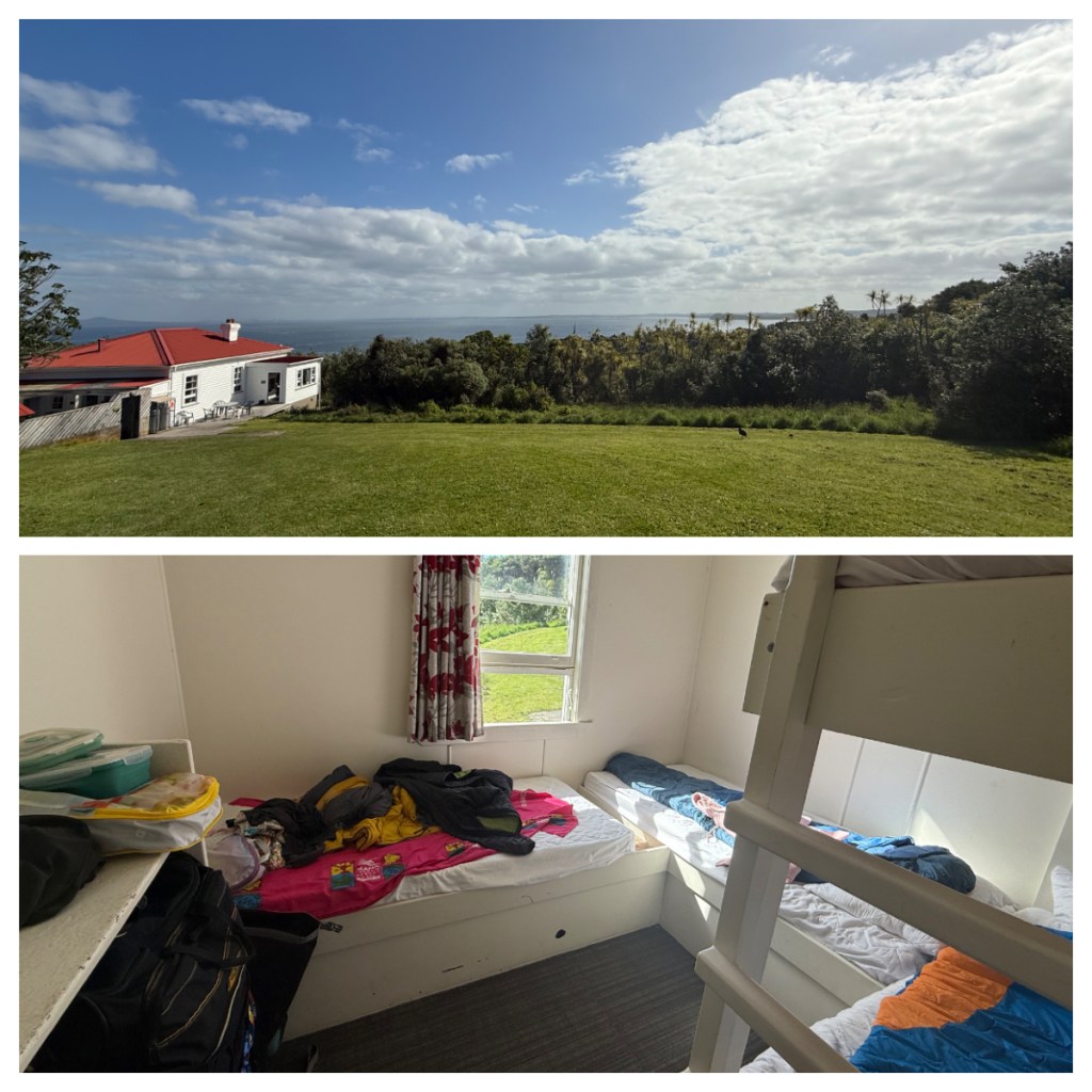
Visiting the island was something I have wanted to do for a long time, and to make it worth the trip north I wanted to stay the night.  One of the old lighthouse keeper houses has been turned into a bunkhouse for island volunteers and visitors.  The 15 beds for guests fill up quickly so I was lucky to get a bed for a Saturday night.

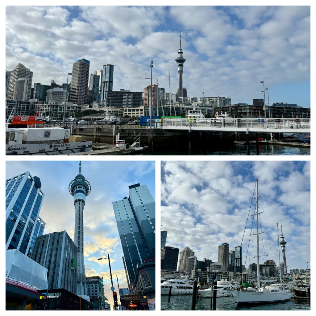
Ferries to the island only run once a day, and the 8.30am departure from the Auckland viaduct wharf, meant I had to travel up to Auckland on Friday afternoon, to ensure there was no stress on Saturday morning, and what a beautiful morning it was. 

As the island is pest free, biosecurity is an important part of the pre-boarding process.  I had already received details about ensuring there was nothing in your bag before packing, including checking any Velcro for small seeds, cleaning footwear and ensuring food is in sealed containers.  On the wharf, we also had a preboarding briefing and a final shoe clean before finally being able to board the book. 

For other islands, I have actually had my bag checked, but I think the numbers going to Tiri are much larger, particularly for day trips that is probably not feasible.  People can also go to the island on their own boats so there is really no way to police it, rather than informing people of the importance of not bringing unwanted pests to the island.

The ferry left Auckland Viaduct and headed down through the Waitematā Harbour – this translates to sparkling waters and the waters of the harbour were really sparkling as we travelled and dodged the many kayakers out enjoy the morning. 

After an hour, we stopped at Gulf Harbour to pick up a few more passengers, before travelling the final 30 minute to the island where we were immediately welcomed by birdsong song and I was excited to be there.

There was a little organised chaos getting off the boat. I had to find the place to leave my overnight bag (which would conveniently be taking up to the bunk house for me), and then having a briefing about staying overnight at the same time as getting a briefing for my guided walk!  There were two large groups and I felt for the poor volunteers who were ‘herding cats’- not literally of course as it’s a bird sanctuary so no cats – but figuratively.

All guests to the island have an option to book a guided walk (for the small price of $10) with a volunteer from the Supporters of Tiritiri Matangi organisation and I had decided to do one as I have plenty of time to wander on my own.  Before heading out on my walk, one of the volunteers said, “give the old trees a chance to talk to you as you walk past – they have great memories”. I love this and is a good reminder that this should be a slow purposeful walk, not the march I normally do!  It is always the best way to spot and hear the birds, and the trees too so it seems!

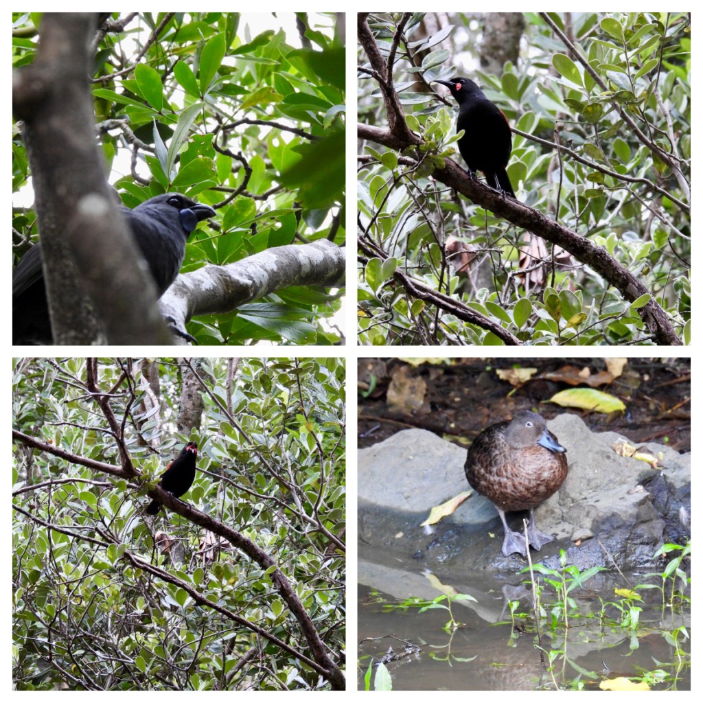
I was lucky enough to be in a group with only 2 other guests and a lovely guide, but there were a lot of large groups on the same track so we were often passing and/or being passed.  I was glad to have taken the guided walk as I must admit, there were a couple of birds that I probably would have missed had I been on my own – in particularly a Kōkako and a Titipounamu (Rifleman).  Both birds I had never seen before and was very excited to spot.  Particularly the rifleman, New Zealand’s smallest bird (less than 10cm long and weighing in at only 6g) so notoriously hard to spot.

Birds spotted on the walk included Korimako (Bellbird), Tūī, Kereru (NZ Wood Pigeon), Kākāriki (Parakeet – Red Crowned in this instance), Hihi (Stitchbird), Kokako and Titipounamu (Rifleman). 

Many of New Zealand’s endemic species are rare/vulnerable so it is amazing to have the opportunity to see them here, and to see them thrive in this pest free environment.  Unfortunately, in the shade of the bush it was not easy to get photos of some of the birds, but I was just excited to see them!

I got back to the bunk house for a quick briefing on how everything works.  It is pretty well kitted out with microwave, cookers, all the kitchen utensils and crockery you could need …. And hot showers – all pretty fancy by DoC (Department of Conservation) hut standards!  I was in a room of 4 bunks, but as I had done a guided walk, I was the last one in.  I was grateful to have been left a bottom bunk!

After lunch and bed set up, I headed out again to explore a different part of the island.  First stop to admire a Takahe family with a chick.  Takahe are flightless, and the largest member of the Rail family and have an amazing conservation story in New Zealand.  Thought to be extinct until 1948, when a small population was discovered in the mountains of the South Island.  Various captive breeding programmes over the years have brought the population up to around 500 individuals and they have been successfully introduced to predator free islands and even to a couple of areas on the mainland. 

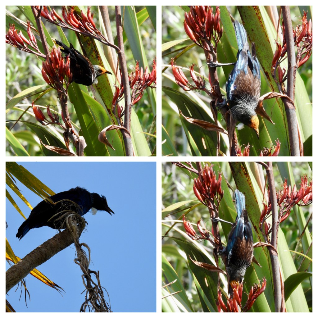
Continuing on spotted tīeke (saddleback), Pōpokotea (whitehead) and so many Tūī. I ended up plonking myself down in the middle of a path as they played, fought and feed around me.  There is nothing more icon than Tūī in the sunshine with their pollen covered head stuck on a Harakeke (Flax) flower 💚 In most lights they look black, but in the sunshine their true colours shine iridescent blues and greens.

I should note that you cannot expect to surprise anything in the NZ bush when there are tīeke around.  They loudly announce your presence with their “ti-e-ke-ke-ke-ke” call that gave them their Māori name.  One starts, and the rest continue it throughout the bush!

No kiwis were spotted at night (by me anyway) but I was up just after 5.30am to get out for the sunrise and to immerse myself in the dawn chorus.  The air was filled with the calls of the tīeke, Robin, Hihi, Pōpokotea and Tūī trying to boss everyone else around.  I spent a lot of time sitting and listening and it paid off – I spotted a pair of Kōkako, feeding at the top of the tree above me so just laid down and watched them.

I passed a little Pāteke (Brown Teal) family,  dabbling through the bush before I headed back up to the bunk house to pack up my things and have some breakfast. 

My next mission was to walk down to the northern end of the island.  I walked back along the track I had done on the guided walk on the day before, ensuring I was heading out before the boat arrived full of day trippers.  This time the Korimako were dominating the airwaves, and I was lucky enough to spot a few Kōtare (Sacred Kingfisher) and a sleeping Ruru (Morepork) in a tree.

The northern end of the island gets different wind and weather conditions so the vegetation is a little different than the southern end.  Lots of harakeke in flower and even a few Kōwhai trees still in flower.  The one thing that is almost more icon than a Tūī in a Harakeke flower – it’s a Tūī in a Kōwhai tree lol.

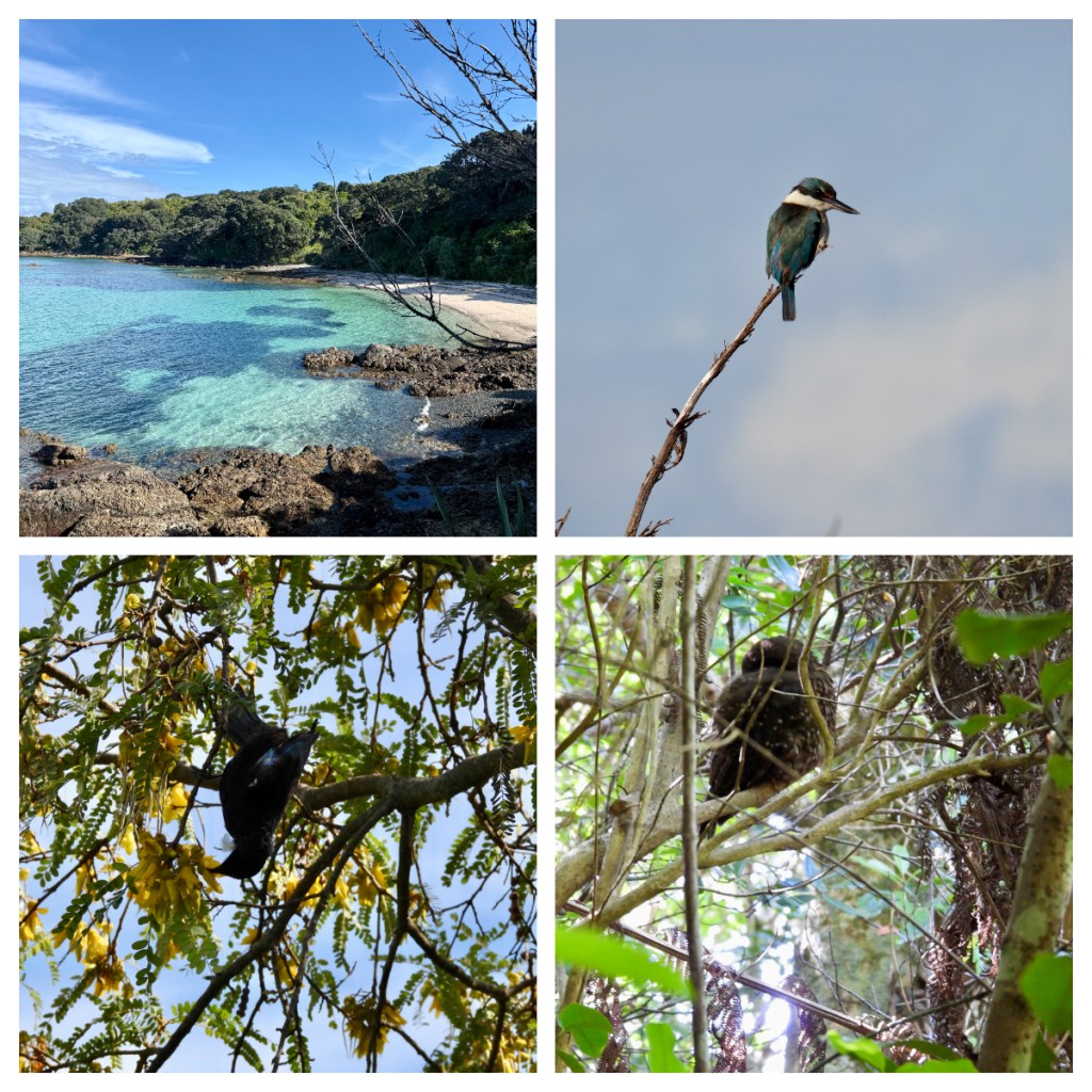
This was a long walk, over 8kms, but I was rewarded near the end by another amazing Kōkako interaction. This time they were much lower down and watched them eat for ages. 

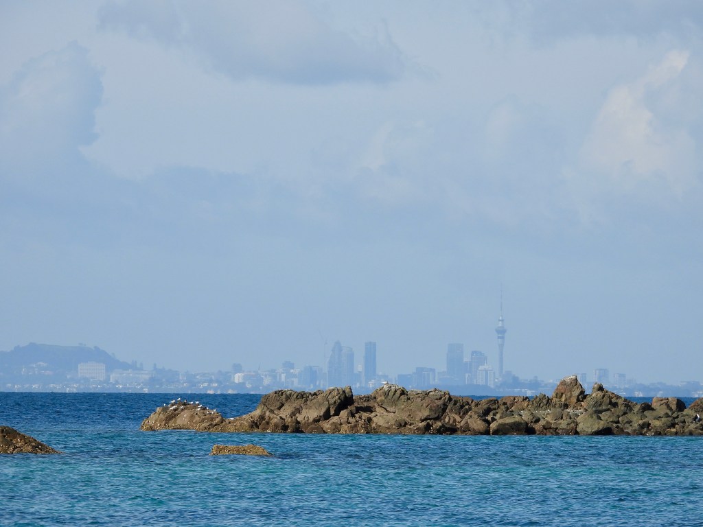
I relaxed for the rest of the day as I waited for the ferry (at 4pm) to take me back to Auckland.  It is amazing that you I can just look past the bunk house and see the  city – it feels like a world away on this little island paradise and a great weekend getaway for a bird nerd like myself.

All good things must come to an end

Yerevan, Armenia

April 2025

And so we had come to our last full day on holiday and the day started with a perfect mountain view from breakfast. Despite being in another country (Turkey), Mt Ararat (little and greater) dominate the Yerevan skyline.

We first headed to the Cascade complex were we first met Alexander Tamanian, the architect responsible for much of the Yerevan we see today.  He created the first plan of the modern city which was approved in 1924 and transformed the small city into a modern capital.  His statue at the bottom of the Cascade has earnt him the nickname “the DJ of Yerevan” – do you see it? 😂


When he started, the city only had a population of 45,000 and he had the foresight to plan for a city of 500,000 but the city grew so rapidly, it now has a population of over 1,000,000!

We walked through the formal gardens of Cafesjian Sculpture Garden which holds a collection of sculptures from all over the world.  The private collection included a large lion made of old tires, I spotted a Botero (from Colombia) and was pleasantly surprised to meet the first other kiwi I had met on the whole trip – this one was a very large blue one, and part of the exhibition. 

The Cascade’s formal name is the Cafesjian Centre for the Arts and was originally the idea of Tumanian to connect the city together, but the plan was forgotten.  After a few false starts, in the 70’s, 80’s and 90’s, the complex was finally completed in the early 2000s, funded by  Gerard Cafesjian, an American Armenian who funded over $120m of projects in the country.

From the bottom to the top of the Cascade it is 300m high, with an escalator on the inside (with different galleries and event rooms on each level) and over 550 steps on the outside.  We went up the escalator and then wandered slowly down the stairs admiring the views across the city to Mt Ararat.

As it dominates the city, Mt Ararat dominates the centre of Armenian coat of arms, along with Noah’s ark balanced on the top.  Apparently, the Turks said that the Armenian’s couldn’t have Mt Ararat on their coat of arms as it is not in Armenia!  Their reply was, well you can’t have the moon on yours as it is not in Turkey … lol.  So Turkey has the moon and Armenia has Mt Ararat lol.😝


Our next stop was the Matenadaran – the Museum of Ancient Manuscripts.  Established in 1959, it not only houses a huge collection of historical manuscripts (from Armenia and around the world), but also a scientific research institute.  We had a guide to take us around and introduce us to some of the most important books.  Some of the standouts to me were a 5th century Armenian manuscript on animal skin parchments, the largest book from the 14th century, weighing in at 28k (which took the skins of 660 newborn animals to make) and the smallest book from the 15th which weighs 19g and took only 1 newborn lamb to make.

The animal population of Armenian must have been pleased when they moved to using paper for books!  Apparently, Armenia was the 3rd country in the world to use paper after China and Arabia).


They had a wide collection of beautiful, colourful religious books, some made in the ancient Armenian Kingdom of Cilicia.  They used gold leaf, garlic juice and beetles for the red colour.  Apparently, it took 1000 beetles to make 1 gram of colour!

It was an interesting visit and it hard to imagine that they only have 1-2% of their collection on display! 

Levon had recommended a local sweet shop to purchase gifts to take home – New Zealand has very strict biosecurity rules and everything needs to be commercially made with country of origin and ingredients listed, so we had a quick pit stop at this amazing candy land type shop that sells chocolate coated dried fruit and nuts. 

After securing my purchases we headed to the equally candy land themed café next door to sample some freshly cooked ponchik – a filled, fried sweet dough.  I can confirm they were delicious.

We wandered back down towards the city centre, pausing for a moment in the ‘musical quarter’ – the home to Conservatory Park and the Theatre of Opera and Ballet.  One of the prominent statues is of Komitas, a priest, composer, singer and the pioneer of Armenian folk music.   He would walk from town to town compiling local folk music.

During the Armenian genocide in 1915, he was arrested, along with hundreds of other Armenian intellectuals, and deported to a prison camp.  He was allegedly saved by the French ambassador but suffered from PTSD and spent the rest of his life in a psychiatric hospital in Paris.   He is not only considered the saviour of Armenian music but also thought of as a martyr of the genocide.

Although we were walking around the central city today, Yerevan does have a Metro system – well, system may be a strong word, they have one, single Metro line that does not connect anything particularly useful!  It was built in the late 70’s and at the time, Yerevan only have a population of around 40,000 people.  Not nearly enough to justify the costs!  Apparently, they staged fake traffic to justify getting the money from the Soviet Union for the build! 😂

Our wanderings took us past the large carpet ‘statue’ we had seen the night before, the puppet theatre with it’s beautiful mosaic tiles and the oldest surviving church in the city (13th century I think).    We passed a mural of Edgar Alan Poe, that was painted by Levon’s wife,  the 1936 “Moscow” cinema and continued down a beautiful tree lined street that is lined by some of the oldest buildings in the city (which to be honest are not that old as the city has been destroyed many times). 

There was a beautiful building from 1915 that once housed the first private hospital in the city and then an 1880’s traders house that today is home to the Dalan Gallery and Restaurant.  From the street it just looks like a souvenir shop, but you can walk through the shop into the courtyard out the back into the restaurant and upstairs to explore the old house.


Back in the car, and we headed out of the city for our lunch spot at Vagharshapat, the Machanents House.  It is old house that has been turned into a social enterprise, providing artesian lessons in weaving and pottery, theatre and a national cuisine school, mostly for disabled people.  There is also a popular restaurant where we enjoyed lunch (which included a pizza face ☺️).

The main reason for our visit to Vagharshapat was not lunch, but the large religious complex that is considered the seat of Armenian Christianity and that houses the residence of the Armenian churches pontifical, as well as the oldest Armenian church that isn’t in ruins – the Etchmiadzin Cathedral.  Built in the early 4th century, it is believed to be the oldest cathedral in the world and is still a site of major pilgrimage today, as was evident from the amount of local people visiting.   

The Etchmiadzin Cathedral is considered the mother church of the Armenian Apostolic Church and was thought to have been built by our old friend Greogry the Illuminator (in fact you are greeted by life size carvings for Gregory and the King as you enter the complex through the imposing gates).  Not surprisingly, the cathedral has seen various iterations over the years due to earthquakes, plunderings and general neglect, so what we see today shows a number or different styles of architecture and seems to be fairly recently refurbished inside and it was stunning.

The Cathedral was beautiful and to be honest all looked rather new, but there were Perspex areas on the floor where you can see a small part of the 4th century foundation.  This was in stark contrast to our next stop, just a short drive away at the ruins of the 7th century Zvartnots Cathedral.

This Cathedral was unique in its circular shape and that fact that it had a multifloored design and stood at around 50 metres tall.  Unfortunately it only stood for 320 years before collapsing in the 10th century, probably as a result of an earthquake, despite being designed to last 1,000 years!

There was a small but informative museum on site that had a scale model of what it would have looked like and wandering around the site itself was really interesting.  At 25C it was our hottest day of the trip and we could see out to Mt Ararat (over 5,100m) on one side and Mt Aragats (over 4,000m) on the other.

Apparently, Armenian’s say that Mt Aragats is the highest mountain in the Republic of Armenia, but Mt Ararat is the highest mountain in Armenia, referring to all the land that was once part of Armenia!

As we drove back to the city, we made a brief detour to the Armenian Genocide Memorial complex.  We did not have much time so didn’t visit the museum but did a quick walk around the monument.  We were visiting the day after the Genocide Remembrance Day, that remembers April 24th, 1915, when the atrocities started. 

A quick history – the Armenia genocide refers to the annihilation of ethnic Armenian’s from the from April 1915 through to September 1916 by the Ottoman empire. They started by rounding up academics, politicians, musicians, artists etc in one night and killing them all.  Then those menof army service age were sent to work in prison camps, many dying later of starvation, exposure and disease.  Children were forcibly removed from their families and forced to convert to Islam.  It is reported that over 1 million people were killed.   

The Ottoman Empire did not recognise the genocide and say it was just part of WWI when lots of people died. Even today, many countries including Turkey, do not formally recognise it as genocide. Despite that, its impact on Armenia and its people is everywhere, and the reason that there are such large diaspora communities around the world as they fled the genocide and its aftermath.  

The monument itself is made up of three different parts.  Firstly the 44m spike which symbolised the national rebirth of Armenia.  Secondly, 12 slabs in a circle, representing the 12 lost provinces (which are now in Turkey) and it’s eternal flame.  There is also a long wall that lists all the areas and towns that were lost and people killed or removed.

I am not 100% sure what happens on the Remembrance Day but the whole area must have been covered in flowers and there were large groups of people cleaning them up and piling them high around the eternal flame.  It was a sobering site but an important part of understanding part of the history of Armenia – a country and a people that we had definitely grown to love.

It was sadly now time to say goodbye to Levon as he dropped us back at our hotel.  We had thought it would be tough to match Tazo, our Georgian guide who was amazing, but Levon managed to do that.  If you want a guide in Armenia, who’s not only knowledgeable but funny, kind and prepared for ever eventuality, he is your guy!

Being our last night, we decided to head out for a lovely last glass of Armenian wine and see the Cascade at night.  As we enjoyed our wine, thunder and lightning started cracking around us and despite deciding to try and get back to our hotel before the rain came (about a 15-minute walk), we did not get far … and when the rain came, it came hard!!!

(We might have got back before it started to rain if we had not stopped for 10 minutes to try and take photos of the lightning ☺️.)

We took  refuge in a bank ATM vestibule, or maybe it was a package collection place, either way we thought we could and wait out the worst of it.  We could not, so made a break for it and although the rain had subsided a little, the footpaths and roads were rivers that we had to wade through so there was not hope for the shoes.

When I had got back to the hotel in the afternoon, my room was incredibly hot (almost 30C) and the reception just told me to open my windows … of course I did not close them before going out and now the floor is also soaking wet … nothing that a towel on the floor won’t fix by morning , I hope 😉.) Armenia was certainly full of excitement right till the very end ❤️. (We thought we had it bad, Levon sent us a video of him driving on roads that were completely flooded!)

The long trip home was relatively uneventful. A little confusion for my airport pickup (they waited outside the hotel, I waited inside lol), but the airport was relatively small and quiet so plenty of time for immigration to scrutinise every page of my passport.  A slightly diverted flight to avoid flying through very high cumulus nimbus clouds. 

6 hours in Dubai airport (at least I did not have to rush for the 2 buses and then a train to change terminals this time).  14 hours to Sydney and a lovely view of the city coming into land, and then the final hop across the Tasman Sea and home.

I really enjoy writing these blogs and I do hope that someone enjoys reading them and/or finds them informative lol.  It gives me an opportunity to look back at photos and remember what we did each day whilst it is still relatively fresh in my mind.  This was definitely an incredible trip, one that I would highly recommend and in fact would love to come back again to dig deeper.  There is always so much more to see.

Museums, markets … and more monasteries (and a pagan temple)

Armenia

April 2025

The hotel restaurant was on the 9th floor of the hotel with a view out over the city and Mt Ararat. When I went up for breakfast, it slowly came in to view under the clouds.  Unfortunately, by the time we came to leave for our day of activities it was raining.

Levon recommended we switched our activities around because of the weather  … and so we headed out of town to the Garni Temple complex.  The roads were terrible.  Apparently they were fine last week, but with some sustained heavy rain, they had turned into rivers with huge potholes! 

The locals joke that some of the potholes are so deep you loss cell phone reception if you go into one lol. If the potholes were not bad enough, part of the route was also in a landslide zone, where the ground and the buildings built on it, were slowly sliding down the hill! 

The Garni Temple is the only preserved pagan temple in Armenia and it is thought to have been originally built sometime between the years 100-300AD (remembering they became Christians in 301).  

The temple itself is a combination of Greek and Roman architecture and has 24 columns to symbolise 24 hours in a day, and 9 steps to symbolise the 9 social classes accepted in ancient Armenia.  For some reason, on this site, instead of destroying the pagan temple and building the Christian church on top (which happened everywhere else), the temple was kept, and the church built beside it.

Unfortunately, after surviving Christianity and multiple invasions, the temple succumbed to an earthquake in 1679.  It was restored in the 1970’s, using its original basalt stones, to what we see today.

They were obviously setting up for a concert and not only were all the lighting and cables ruining my photos, they also seemed pretty unsafe.  All the electric cables were sitting out in the rain and they were also a massive trip hazard as we climbed over them to get around the temple! Armenia health and safety at its finest! 😜

The site also served as a royal summer palace with a bath house/sauna and palace buildings.  The remains of the bath house has beautiful Greek style mosaics and one image that looks like a woman holding a smart phone??  They actually piped in the water for the bath house from 5km away in clay pipes.

One of the most important artefacts at Garni is the Dragon Stone or vishapakar, a monolith that predates the Khachkars.  It is believed that these date back to the Kingdom of Urartu, that dominated the Armenia highlands (which now extends over modern day Turkey, Iran and Armenia) from the 8th to 6th centuries BC.  It is crazy that this incredibly important artefact is just sitting out here with no protection from people or the elements!

You can see why this was a favourite spot for royalty, with it stunning views down the valleys on both sides (also making it hard to invade).  You can also see down to the “Symphony of Stones”.  Armenia’s version of the hexagonal (and some pentagonal) basalt columns, some nearly 50m high, that I have seen in recent years in Northern Ireland and Iceland.  They are now protected but were once cut to make the paving stones we were walking on.


As we exited the site, we passed more stalls with people selling their beautiful homemade products.  As with all our experiences in Armenia, they all wanted us to try their products even if we were not going to buy.  I always felt bad doing this but Levon told us they would be offended if we did not try lol.

It was odd to see how interested people were when they found out that we had been to Azerbaijan.  They would always ask what were the people like and what did they say about Armenians.  It really does seem that they are afraid of each other.  Levon said that people felt like they would be killed in the streets if they somehow found themselves in Baku! I can’t image what it must feel like to have such fear of a neighbour.

The rain had let up a little by the time we got to our next stop – Geghard monastery.  Another medieval monastery, this time partially carved into the cliff.  The complex was founded in the 4th century by our friend Greogry the Illuminator on the site of a sacred spring in a cave, that is still there and locals collect water from it.  It is believed that Gregory lived here for some time.

The name, Geghard, means spear, and allegedly, the spear which had been used to wound Jesus when he was on the cross, was brought to Armenia by the apostle Jude and it had been stored on this site!

Some parts of the complex are dug entirely into the cliff, others are stand alone structure, most built between the 10th and 12h centuries but as with most sites in this part of the world, it has suffered from invasions and earthquakes, in this case, also fire!

There are many Khachkar’s here, lining the rock faces and in some places the stones are carved directly into the rock walls and the main church is adorned with carvings of grapes, pomegranates, doves and a bull fighting a lion, thought to symbolise the prince’s power!  Apparently it took 40 years to build the cave monastery, digging it out from the top down and it had lovely acoustics.  (We convinced Levon to do a demonstration of said acoustics lol.)

From one of the upper tombs, there is a hole down in to one of the downstairs tombs.  Not sure if it is natural or manmade but it makes a good photo opportunity.

The rain came again so we ran back to the car and travelled through the now substantial surface water back into Yerevan.  It is clear that they have very poor drainage systems that can’t cope with heavy downpours and we were grateful to be driving in a suitable vehicle!

Back in town we stopped at the large “GUM”market (named after a nearby department store).  It was huge and mostly indoors (which was great on a day like this one).  It reminded me of markets I have seen in Kazakhstan.  Shoes, clothes, suitcases etc could be found upstairs, and food downstairs – fresh and dried fruit, nuts, vegetables, spices, meat, cheese, herbs ….

Again, we got lots of free samples and thankfully Ania bought some to take home, and I bought a little to eat today!   We have seen churchkhela around Armenia and lots here in the market.  Apparently here they call them the “Armenian Snickers” as they are sweet and nutty.  They are spiced here (with a little cinnamon I think) and I prefer them to the Georgian ones.  You can also buy them in small pieces, rather than just in the long sausage shape which is much better for me.

We wandered through the market, sampling many of the products and Levon recommended we had lunch at one of the ‘hole in the wall’ places on the edge of the market.  We were also keen to try local food so were happy to take him up. 

As is normal, I did not make a note of what it was called (but I did take photos of the lady making them in the small hole in the wall shop.  It was basically a lavash bread dough, with 15 types of herbs rolled in to it.  One site I came across on the internet called it Jingalov Hat (in English) so we will go with that.  It was delicious, what ever it was called.

From the market we headed in to the centre of the city.  Yerevan is clearly a city where the old and new stand side by side, although its seems that much of the old is being demolished to make way for more of the new!  It is also a place where Teslas coexist with Soviet era Ladas!

Yerevan is one of the oldest continuous settled cities in the world, starting in the 8th century BC with the building of the fortress of Erebuni.  It has been destroyed a number of times by earthquakes and only became the capital of the First Republic of Armenia in 1918.  I will probably touch more on this in the next blog. 

Parking is definitely at a premium and we did have to park some distance from our destination.  At least this gave us the opportunity to walk through the streets, passed lovely looking cafes, breweries and fancy restaurants. It is most definitely a cosmopolitan city today. 

Republic Square, the central town square was our destination. The “square” (its not really square) is surrounded by five major buildings, built in the pinkish “tuff” (local volcanic stone) which includes Government House, a hotel, and the History Museum of Armenia.  There are also musical fountains but unfortunately, we were too early in the year for them to be operating.

Construction of the ‘new’ city started here in 1923, though these buildings were not complete until the 1950s. Not surprisingly, during Soviet times, it was called Lenin Square, it had a large statue of Lenin and was the location of many Soviet parades.

We were in the square to visit the History Museum which was vast with so much information to take in.  We had a guide, who was French/Polish young man who was in Yerevan on a youth exchange but he had certainly done a lot of work learning about all the history.

I noted a few of the most interesting things we heard/saw:

  • The museum houses a 15th century door that once lived at the Sevan monastery.
  • The earliest settlements outside of African were in the Armenian highlands and had many ancient civilisations that I had never heard of!
  • We saw the actual leather shoe that was found in the Areni-1 cave we had visited the previous day.
  • Apparently, there were lions in the Armenia highlands until the 12th century are there are still leopards (the rare Caucasian or Persian Leopard) today.
  • The Urartu Kingdom, also known as the Van Kingdom (which we had met earlier in the day at the Garni temple) were very powerful and had their own unique language.
  • Wine is part of the culture (I think we knew that already lol).
  • First Armenians were seen in the 6-4 centuries BC, under Persian domination.  The took advantage of Alexander the Great’s death to get independence.
  • Tigranes the Great (or King Tigranes II) became ruler at 14 and ruled from 95 to 55 BC.  He lived until 85 and is still considered  a great ruler.
  • Armenian’s are very proud of their Christianity and it helped them get their freedom from the Zoroastrianism Persians and Pagan Romans.  Along with Gregory the Illuminator, apostles Thaddeus and Bartholomew were also instrumental in the formation and spread of the Armenian apostolic church and creation of the Armenian identity.
  • The Armenia alphabet was oral until the 5th century when a monk was asked to create a written language.  The 36 symbols or letters he came up with are based on the phonetic principles of “one symbol for one sound”.  Having a written alphabet was of great political and cultural importance.
  • The Bagratid Armenian Kingdom once ruled most of present day Armenia and eastern Turkey and it’s capital , Ani (from 961 to 1045)  was of strategic importance and was one of the world’s largest cities in its heyday.  Unfortunately, today, it sits in eastern Turkey  which makes it difficult for Armenian’s to visit but they still consider it a symbol of Armenian national heritage.

It was definitely a lot of information to take in, in just one short hour but definitely worth a visit.  Before finished up for the day we had a quick look around a derelict building which is currently being used as a bar and small shops by some Russians – at least until the entire building is knocked down to make way for another new tower block!

Yet another busy day ended up back at the hotel for a couple of hours before going out for dinner – I even changed and got a little dressed up, the first time on the trip! Every day was so busy we were always exhausted and too tired to doing anything except eat 😂 .  (This is not a problem for me lol.)

We had a lovely dinner in the very busy Yerevan Tavern before wandering back down to Republic Square via a pedestrian mall. The rainy day had turned into a lovely evening so it was nice to join the Friday night crowds for a while. 

We finished up in the bar on the 9th floor of the hotel for a view up to Mother Armenian and the ‘Yerevan eye’ lit up for the night. 


Caves, canyons and wine

Armenia, April 2025

I was back in fine form today and I was ready for our busy day ahead.  Our first stop was at Zorats Karer, also known as Karahundj, or the Armenian “Stonehenge”.   Despite it already being around 9.30am, the site was closed and after waiting for a short time, taking in the beautiful morning surrounded by mountains and bird song (and the toilets with a view), we went on a mission to get in! 

This resulted in us walking through the field next door, through thick clay like mud that stuck to our shoes – by the time we got to the fence on the other side our shoes were sooooo heavy, caked in this mud!!  We then had to slide under the fence, and I was very grateful I did not put clean trousers on today 😂 – it was all part of the fun though and there was no way we were going to miss out on this. 

Unlike the English Stonehenge, which you can now only view from a distance, this megalithic site is free for us to roam around, despite the fact that these stones are thought to be 3,500 years older than the English equivalent!!

There are over 200 large stone monoliths, 80 of which have distinctive holes bored near the top edge and the purpose is still being debated.  Most consider it an ancient astronomical observatory (it was one of the world’s first), but other theories include a Monument to the Sun God and/or a burial site or sanctuary for soldiers.

It was an incredible site to see and by the time we had finished looking around, the site caretaker had turned up and unlocked the gate (so we did not have to walk through the field again to get out).  Of course she did tell us off; to be fair she only told Levon off, for effectively breaking in 😂 .

Every day in Armenia seems to bring windy mountain roads and spectacular views and today was no exception as we continued on through the countryside, passing through more small towns.  Most with friendly stray dogs, some with Storks, nesting on power poles (as we saw in Georgia).


Our next stop was Areni-1 Cave complex, named after the endemic Areni grapes, which grow in the area with very little water.  This particular cave complex became renown in 2008 when a PhD student, researching the early Bronze Age site, found an old shoe!  Not any old shoe, perhaps the oldest complete leather shoe found in the world, being dated to approximately 5,500 years ago!   Despite its age, it is in pretty good condition due to the cool and dry conditions in the cave, and the layer of sheep dung it was sealed in!  The actual shoe is now kept in the museum in Yerevan.

Other artefacts found in the caves include weapons, jewellery, ceramics, petrified grains, apricots and grape seeds, burial jars with human remains.  They also found wine making artefacts dating back more than 6,000 years!  Only 10% of the cave complex has been excavated so there are likely to be more exciting and important finds in the future.


As a side note, Levon told us that during Soviet times, the Soviet rulers insisted on all the winery’s making Brandy rather than wine and Armenian brandy was some of Stalin’s favourite.  He actually supplied Churchill with it!

We had lunch in a lovely café covered in beautiful wisteria and this time Levon recommended something with buckwheat and mushrooms (Emmer Pilav), something with the wild herbs that we have seen people picking on the road side and egg (Mandak)and then a meat dish which can be served cold (which is very fatty) or hot cooked with egg which we opted for. 

If I recall, this is a very traditional dish, where the meat is cooked with lots of fat and then stored in clay pots to preserve it (dating back to harsh winters before refrigeration and war time).   Google tells me it is called Ghavurma.  Having it cold with all the fat was a stretch too far, but cooked with the eggs it was pretty tasty. 

It is quite clear to me that I will never be a food blogger!  I forget to take photos before we start eating and/or I forgot to properly note what we are eating!  Whatever it was, it tasted good!

I might just note that there are more Lada’s here, and even a new one, so they are clearly still making them. I bet they won’t last the many decades the old ones do!

From our lunch spot we drove through the stunning red cliffs of Noravank Gorge to the Noravank Monastery complex.   The area actually sits in the Noravank Sanctuary which covers a number of diverse ecosystems, as well as being home to Bezoar goats (or ibex) that are native to this region. 

We did scour the higher areas to see if we could see one, but sadly not – thankfully Levon has one tattooed on his leg, so we kind of saw one??  Super guide Levon comes through for us again lol.

The monastery itself dates back to the 12th and 13th centuries (after the earlier 9th structures were destroyed in an earthquake) and was the residence of Orbelian princes and now the resting place of kings.  It is much more ornate that most Armenian churches and is the only church which has an image of God in human form (a practice that is against the Armenian Apostolic Church’s rules). In the intricate carving, he is apparently holding Adam’s head in his hand and it was supposed to be a simple explanation of the bible for those who could not read.   

After exploring the complex, we headed back down through the gorge (stopping for photos and taking video as directed by Levon lol) and it is time for wine tasting at Areni Winery.  A family run business that manufactures around 250,000 bottles a year from local grapes, some in the traditional clay pots and some in the European barrel method. 

As in Georgia, I preferred the barrel method wines, but perhaps it is because that is what I am more used to? They also had a number of fruit wines (peach, raspberry, blackberry, cherry and pomegranate), all of which were very strong.

My favourite here was the semi-dry red, and I decided to purchase a bottle.  Not just any bottle.  One dressed in the costume of a traditional Armenian man lol.  The outfit cost a lot more than the wine but I must admit I love him – and have named him Armen.  Armen the Armenia wine guy 😜 .

After a few days of low cloud, rain and cold, it was lovely to have some warmth and sunshine again as we drove through a small part of the country that bordered on Turkey, Iran and part of the Azerbaijani occupied territory of Artsakh.  The good weather meant we got our first glimpse of Little Ararat, and her famous big sister, the mighty Mt Ararat of biblical fame – where Noah’s Ark landed after the flood.

We continued to pass cars and trucks that looked so old and so battered that we were surprised they could be on the road.  Levon told us that although there are ‘fitness’ checks for vehicles, if they were extensive (like they are in other countries) there would be hardly any cars on the road!  Apparently, they only check brakes and lights and sometimes even those checks are falsified!


As we were close to the border(s) we talked more about the ongoing territory conflicts in the area. It turns out that not only is Levon a superstar guide, but he is also a bit of hero! Back in 2020, he and a number of friends went over the border into Artsakh in the middle of the night to save khachkars from likely destruction. Some of those saved were over 1000 years old.

We stopped at the perfect photo stop with the Khor Virap Monastery over shadowed by Mt Ararat and the beautiful Armenian flag flapping in the wind.  Unfortunately, the lighting wasn’t perfect but it was still a stunning view!  From here we could also see how close we were to the border with Turkey (see the white mosque). 

Despite being right on the border with Turkey, there is no open land border crossing between the two countries and to enter Turkey, you actually have to travel up to Georgia and then cross from there.  This is testament to the tense relationship between the two countries since WWI.

The Khor Virap monastery was one of the most touristy sites we had visited on the whole trip, with a huge line of souvenir stalls lined up on the pathway to the monastery.  Thankfully it was not that busy at the time we were there, but it is one of Armenia’s most important religious sites. 

As I have mentioned in previous blogs, Gregory the Illuminator brought Christianity to Armenia in 301AD.  Ironically, he was assistant to the pagan King Tiridates III and initially, the King tortured him for his Christian beliefs and then imprisoned him and left him to die when he heard that Gregory’s father had murdered his father!  His dungeon, and home of 13 years was at Khor Virap, which actually means “deep dungeon” or “bottommost pit”. 

But he did not die, and 13 years later when the King became sick (apparently because he ordered the death of 40 women preaching Christianity), his wife dreamt that only Gregory could save him.  So he was brought out of the pit, cured the King, was given salvation and the King accepted Christianity!  Well, that was the story we were told. 

I have read some variations on this but the gist is the same.  Punished by the King for being Christian, someone had a dream Gregory saved the life of the King, the King converts … the end. The pit that St Greogry was allegedly kept in is still open for people to climb down, via a steep ladder.  There was a bit of a queue so we did not bother!

The first chapel was built on the site, in a mark of respect to St Gregory in 642 and this has been repeatedly rebuilt over the centuries until 1662.   Today you can see inscriptions on the buildings which apparently is graffiti from people fleeing the genocide in 1917/18.

From Khor Virap we continued on the 45km to Armenia’s capital, Yerevan.  It looked huge as we drove towards it, a great sprawling city, housing over a third of the country’s population. 


We checked in to a lovely hotel here, I even had a view of Mother Armenia from my window!  It had been yet another awesome day.  Armenia truly has been full of laughter and kindness.


From spa town to Monastery

Armenia, April 2025

Now Ania was feeling better (almost as good as new) it was my turn to have an off day and I woke with a headache.  Normally when I get headaches like this I don’t get out of bed till midday, but today I had to push through!  As long as I take things slowly, I can normal survive!

We had spent the night in Jermuk, a mountain spa town with a population of around 4,000.  It was particularly popular during Soviet times for medical tourism, and people from all over the USSR would come to convalesce in the therapeutic mineral springs and enjoy the fresh mountain air.  They are trying to revive this legacy today in the hope it will become a modern tourism destination.

After a huge breakfast (a table set for just Ania and I) of which I hardly ate anything, we set out for a short walk around the area we were staying and to visit one of the most famous sites of the town – the Gallery of Waters.  As the names suggests, it is a gallery of different temperate spring waters, each has a pipe with water flowing into an urn below.  Apparently the different waters not only differ in temperature but also different mineral compositions and therefore different healing properties.  We sampled them all and they were all very metallic and not particularly tasty to drink (better than the one in Georgia though) and hopefully now any cancer or liver issues I may have had have been healed! Not my headache though!

From the Gallery, we walked along the banks of the small man made lake (Sarnaghbyur Lake I believe) through the Hero’s Alley.  Along the tree lined path, there are large carved busts of the “Armenian faithful”.  The 6 men and one woman fought for Armenian independence during the Ottoman rule and protect villagers from the Turkish and Kurdish forces.

The final stop on our short walk, was an opportunity to explore the abandoned Palace of Culture (the building I could see from my room window).  Health and Safety is definitely not a priority here as we could easily wander into the building and pick our way through the broken glass and twisted metal!

The Palace of Culture was built in the 1970’s in a classic Soviet style and many towns in ex Soviet states have similar community centres as a symbol of artistic expression.  In it’s brief glory days, the complex included a swimming pool, a library, art galleries and exhibition halls and an 800 theatre hall!  Not surprisingly it was once a bustling community hub.

With the collapse of the Soviet Union, funding for the building stopped and so maintenance and operational money dried up and the building lost relevance and fell into disrepair. By the early 2000’s the building was abandoned and start crumbling into the abandoned relic we were exploring. 

Apparently, a local business man had purchased the building at some point with the  plan to restore it, but the project never got off the ground and there is currently no firm plan to restore the building to its former glory.    Instead it remains as a reminder of a bygone era and a site for adventurous explorers.

As we left Jermuk, we drove up into the clouds and it seemed that there would be no great views today.  As well as cloud, there was some wind and a little rain which did not bode well for our upcoming ‘flight’.  At least that is what they call a trip on the Wings of Tatev aerial tramway!  The tramway is the longest reversible cable way in the world (5752 m long) and it won the World’s Leading Cable Car award in 2021 (who knew that was a thing lol).

The journey takes 12 minutes to cross 320m above the gorge and the Vorotan River to the Tatev Monastery but it does not run if it the weather is bad so it was touch and go if it would be running.  Thankfully it was and one was about to leave just as we arrived so we had to run to catch it – running did not help my headache, nor did the rocking of the cable car in the wind but we made it across unscathed and slowly walking around the fresh air did wonders for my headache. (It we would have had to take to drive to the monastery!)

The Tatev Monastery is one of Armenia’s oldest and most important monasteries and is on the grounds of a pagan temple (there is still one column remaining from this era) and a 4th century church.  The current buildings were built between the 9th and 13th century and given it’s location (and of course before the tramline) it was almost cut off from the world and therefore very safe.   It was an important centre for education (spiritual and general) and over a thousand monks lived here in the 12th century! 

It is still an important site today, and despite the weather, there was a couple having wedding photos in the grounds! 

Apparently, the main Cathedral houses a number of important relics, including a piece of the cross, and relics of John the Baptist, Gregory the Illuminator and the Virgin Mary! 

We also visited the old oil press which houses the technology used to extract oil from seeds in the 13th century.  It looks like hard work!

We grabbed a kebah for lunch and again, people are so friendly, with sellers on small stalls wanting us to sample their products without accepting any money.  Even the guys who we bought the kebahs from gave us fruit (at least we had purchased something from them).  And of course more friendly stray dogs.  Apparently, some are old shepherd dogs (that protected livestock) and in retirement they are just left to roam!  Seems a sad fate, but as I have mentioned before, most of the stray dogs seems in fairly good condition and in very good spirits!

We jumped back on the cable car to cross back to our car before continuing on to the town of Goris where we were to spend the night.  Before checking in to our hotel we took a short walk around the town to see some of the cave complexs in the nearby hills.   We did not go close to them, but even from a distance you could see openings to caves that were actually lived in up until the 1960’s.  Today, some of them house farm animals!

The older part of the city has had a lot of refurbishment of the two story buildings, many decorated with the local “barkash” style of plaster that is unique to Goris. As you can see from the map, Goris is very close to the disputed border with Azerbaijan and there Armenian army has a fairly big presence here.

I was grateful to have a shorter day today so I could recover from my headache and you, dear readers, may be grateful for a shorter blog lol.


Highlands and high lakes

Armenia, April 2025

Before leaving Dilijan we took a quick look around, (after visiting a pharmacy for Ania to top up on drugs (I think she had a mission to visit a pharmacy in every country 😂) first passing a statue that plays homage to the Russian movie “Mimino”.  Released in 1977, the movie is about friendships between  Armenian, Russian and Georgian people.   You can definitely tell which one is the Armenian one – with the prominent, Armenian nose!


We then visited the quaint streets of the Old Town where the traditional Armenian houses have been refurbished and now house artesian workshops (ceramics, textiles etc.) and cafes. There is even a modern khachkar which, when you look in the central hole, you can see a hidden face of the person who commissioned it. Can you see it?


Back on the road and we stopped at a very nice road side shopping complex to try and change some money.  Unfortunately the money exchange office was closed, but one of the workers in the supermarket where it was located said that they could change the money for us, so whilst we waited for them to return with our cash, we explored the rest of the shop where there were bakers cooking fresh lavish and other breads and a wonderful display of eastern style of sweets. 

We went a bit crazy on those, spending way too much and now I had so many sweets to eat in the next 5 days!!

Armenian dram in hand, we were then on our way to Lake Sevan, a large, fresh water, high altitude lake, and the largest body of water in Armenia and the Caucasus region.  It sits at 1,900m above sea level and is around 1,200 kmsq in size.  It is fed by 28 mountain rivers which means it is cold all year round, but apparently people do still swim in it in the summer.

The lake has significant importance to the country as a site for fishing (90% of the Armenian fisheries comes from here), tourism, irrigation and hydro power.  The later two heavily exploited the water, mainly during the Soviet era, and our destination, Sevan Monastery was once on an island, but is now on a peninsula due to the drop in water levels.  Today, the water level is rising again and some structures and forests are already half underwater.

Legend has it, the first church at the Sevan Monastery or Sevanavank  was built by Gregory the Illuminate in 305, on top of the ruins of a pagan temple.   Gregory the Illuminator (C 257 – 331) was the founder and the first official head of the Armenian Apostolic Church and is responsible for the convertion of the population from Zoroastrianism to Christianity in the 4th century.  Some say as early as 301, making them the first country to adopt Christianity as its official religion (earlier than the Georgians that is lol).  We meet Gregory, his story, or one of his churches most days so I will save more of his story for later.  Just note he is the original Christian!!!

 The monastery on the site was founded in 874 by Princess Mariam, the daughter of Ashot I (who later became King) and the site was soon expanded to include a school and a library. 

This site has the 2nd of the 4 Khachckars with an image of Christ. Dating back to the 13th century, this cross stone depicts not only Christ, but he is holding the hands of Adam and Eve, and fighting a dragon!  Or so we were told.

The earliest buildings were destroyed by earthquakes and invasions (the Mongol and Timurid invasions) and today, Armenian churches are built for stability (and hopefully survive earthquakes) and function, rather than beauty. 

Our next stop was in a small town called Martinu where we had lunch in what was a very random kebah shop.  They sent us upstairs to wait, but it was more like being in their house than in a resturant – in fact I think we probably were in their house .  It was interesting to see everyone going about their lives in the small town, though it was very dusty as there was a lot of road works going on. 

This time I had pork bbq in the lavish bread.  The meat was really tasty but there was way too much bread!  There were a lot of friendly stray dogs again, and clearly they are well fed as they turned their noses up at the bread, they were only hanging around for the meat!

It was hard to believe we were already at 2000m above sea level as we were on a plateau with mountains above us, and we continued to climb to 2000m as we drove.  Most of the snow has now gone but it is clear they had a significant dump around the same time we were travelling through the snow in Georgia. 

Generally, the road conditions have not been too bad, but this mountain pass went from good to bad (full of potholes) to really bad (virtual no road at all) and this is a major route through the country, not some back route we had taken.  Levon said that you need to have bad roads to appreciate the good ones!  What a nice way to look at it. 

At the top of Vardenyats Pass we stopped to visit the 14th century Orbelian caravanserai, one of the most significant historical landmarks in Armenia. It was an important stop on the silk road and for travellers through the Mongol Empire.  Although it did have some restoration in the 1950s, it is in much more of its original state than many caravanserai’s I have seen. 

It was very dark inside lit only by small openings in the ceiling, with piles of snow on the ground (that had come through said small openings in the ceiling), and not surprisingly it was cold!  It was clear to see where the people and animals would rest in the large hall but it can not have been comfortable!

The views from the site were beautiful, but what really made this visit was the old caretaker of the site and his wife, who were parked up nearby, selling treasures from their Lada.  They had alcohol, jams, honey, fridge magnets, knives, jewellery – most of which were handmade.  Of course, they insisted that we try everything but would not take any money for it so I pulled out a fridge magnet to give them but this resulted in them giving me a New Zealand fridge magnet in return!  I am not sure how they would ever make any money but they certainly made our visit. 

As we continued on through the mountain pass there were a lot of people parked up by the side of the road collecting herbs that they would then sell on the side of the road somewhere, normally out the back of a Lada! 

We also passed something I had never seen or heard of before – anti-hail stations.  Apparently, hail is a big problem for farmers, regularly damaging crops (sometimes leading to total loss of a season) so dotted around the country side are Zenith Hail Busters. These hail suppression systems can identify potential hail bearing clouds and automatically send a high powered, vertically propagating shock waves in to the atmosphere that impact the structure of the clouds reducing the likelihood of hail.

Coincidently, as we drove passed one of the Hail Busters, we looked back to see an incredible storm forming over the mountains behind us – amazing clouds, thunder and lightning.  It was so impressive we had to stop for some photos.  Levon was so keen for a photo he pulled over, left the car running and ran off down the road to get the best view.   This was the first of his attempts to run away from us and this became a bit of a ‘running’ joke lol.  (As was getting his finger in our photos lol.)

It was spectacular driving through the amazing mountain gorges and through the small farming communities which looked like they have not changes since the Soviet era and the rain finally caught up with us just as we arrived in Jermuk, where we were to spend the night.  We did have to brave the rain to see the Jermuk waterfall, apparently one of the highest in Armenia (at 70m high).  I must admit the waterfall itself was slightly underwhelming but there is an interesting legend behind the local name “Mermaids Hair”.

There was a princess who loved a son of a shepherd and to meet him (which she had to do in secret) she would throw a rope down the river gorge for him to climb up.  When her father found out, he cursed her and said if she ever met him again she would be turned into a mermaid and never be able to leave the water.  She defied her father, began a mermaid and her hair now flows down the gorge!

As we drove in to Jermuk, it appeared somewhat post-apocalyptic, with lots of abandoned buildings (mostly Soviet era) and the view from my hotel room was of a lovely little lake and massive abandoned Soviet music hall!


Being cold and wet we did not want to go far for dinner so ended up in the hotel restaurant.  The menu was HUGE, but Levon recommended Harisa, a traditional dish that was like a chicken and wheat porridge.  Thankfully it tasted much better than it sounds and looked! We also could not go wrong with a local khachapuri with beef and cheese – they are more like pizzas here but still delicious.


Goodbye Georgia, hello Armenia

Georgia & Armenia, April 2025
Georgia was amazing.  Tazo, our guide was amazing and finally, it was amazing having 3 nights in the same hotel and not packing every day!

Tazo picked us up at 9.20 for our 1 hour drive to the border with Armenia.  On this short drive we finally started to see some wild poppies blooming.   The image I had in my head of spring in the Caucasus mountains was snowcapped mountains and fields of wildflowers below 🥴 it seems funny now we have spent time trudging through snow ❤️. Tazo explained that they thought to be “growing from the blood of warriors”.

Before arriving at the border, we passed a large military base with visible missile launchers and jet fighters poking out of their camouflaged hangers (took a sneaky picture or two as we passed and try and spot the base) and far too quickly we had arrived at the board and it was time to say our goodbyes to Tazo and Georgia.

The border crossing was not too busy and it took us around 10 minutes to exit Georgia, before walking the 500m across no man’s land (with the river as a natural border).  It seemed we were the only people walking the distance and most groups of tourists had buses waiting for them to take them across the bridge! 

It did mean we could jump in front of some of the buses to get through the Armenia side (where the queues were a little longer) and before long we were in Armenia and out looking for our new guide, Levon.

So, welcome to Armenia.  Currency here is the Armenia dram and $NZ1 = 230 dram. We were quick to dive into some general information about our new country. 

Like Georgia, Armenia has a unique alphabet and language and in fact the language used today dates back to the year 450.  Unlike Georgia, Armenia is not part of the Caucasus’s but is in fact the Armenian Highlands. I was surprised to learn that much of the country sits on plateaus over 1000m above sea level, with half sitting over 2000m and only 3% lower than 650m!  This gives an average elevation of 1,800m above sea level!

There is often a lot of comparison with Georgia and there is definitely a friendly rivalry between the two, particularly when it comes to who became Christian first, and possibly more importantly, who has the best wine.  😂    Apparently, Georgian’s joke that Armenian’s adopted Christianity before Jesus was born, as they are always bragging about being the ‘first’ lol.

My first impression is that Armenia is more beautiful than I could have imagined and our first stop, at the Haghpat Monastery, helped to confirm that.  As this was our first introduction to Armenian architecture, we learnt a bit about the basics of what we will see in future sites as well.  Situated at 2,500m above sea level, it was also an introduction to the incredible views of mountains and valleys that we can expect from the country.

This monastery is part of a fortified church complex, the earliest parts of which were built during the Kiurikian dynasty between 966 and 991 AD.  Further construction took place in the 12th and 13th centuries when it was an important religious centre that housed 100s of monks.

The complex and its fortifications (the name actually means “huge wall”) have survived earthquakes and invasions and is a great example of medieval Armenian architecture.  It was in fact Armenia’s first UNESCO World Heritage site!

Highlights and learnings from this visit:

The church has a fresco of two kings holding a model of the church. We actually see this in a few places and in fact has helped with reconstructions.

We saw our first Khachkars or Cross stones, some at this site date back to the 13th century.  Khachkars are unique to the Armenian Apostolic Church and are intricately carved stones with crosses and other carvings – often rosettes and botanical motifs including leaves and pomegranates. 

Some actually looked quite Celtic in design.  There are only four that have imagines of Christ on them and one is here at the Haghpat Monastery and the Holy Redeemer khachkar we see here (carved in 1273) is considered one of the most highly regarded cross stones.

The art of carving Khachkars was first seen in the 9th century and today, the symbolism and craftsmanship of Khachkars is on the UNESCO list of Intangible Cultural Heritage. 

Original khachkars were almost liked headstones, to depict the story of a life and are normally found in graveyards or around churches. The ornamental side of the stone always faces west, as do the churches.

Many khachkars have been destroyed over the years, many by conflict with neighbours, in particularly Turkey and Azerbaijan.  In fact the current conflict with Azerbaijan is really only a stones through away from where we are. Between 1998 and 2005, the Azerbaijani government destroyed an entire medieval Armenian cemetery along with over 2,500 khachkars in Nakhichevan and this is considered a “cultural genocide”.

Another feature of Armenia church architecture is the Gavit, a large entrance hall with arches and columns.  Although it can be used for gatherings, it is also often used as a burial site for rich and/or important people and it seemed very odd walking over their graves.  The gavit at the Haghpat Monastery was built in the 11th century whilst the main part of the church was built in the 9th century.  The gavit also had amazing acoustics, which was demonstrated by another tour guide singing – Levon declined to join him despite our encouragement.

We stopped for lunch at a restaurant that was clearly set up to cater for very large groups and there were one or two there (we were very glad not to be on one of them)!  The restaurant did have a beautiful view though it was a little unnerving hearing the thunder off in the distance. 

Lunch consisted of a few Armenia delicacies including kebab (here the meat is served wrapped up in lavash – a simple flat bread), dolma (Ania loves these so they have been a part of most of our meals) and a few other things I did not make a note of lol.  Perhaps I was just too keen to get eating lol.

Over lunch we learnt about the “dark and cold years” between 1990-1994.  After a large earthquake in 1988, the government decided to shut down their nuclear power plants and then the collapse of the USSR, meant Azerbaijan blocked the gas pipeline line (from Turkmenistan) leaving Armenia with a massive energy crisis.  Levon recalls burning books to make fire to keep warm.

We also discussed some of Armenia’s struggles over the years.  Armenia used to be a vast land, stretching from the Black Sea to the Mediterranean but today it is only a fraction of that at 30,000km2 with a population of around 3 million.  Of the 3 million, more than 1 million live in the capital, Yerevan.  There are actually around 1 million ethnic Armenia’s living in California, 2 million in Russia and 0.5 million in Argentina. 

And finally the Armenian flag – which is horizontal lines of red, blue and apricot.  Yes, apricot – did you know that the apricot is the national fruit of Armenia and the latin name of the apricot is actually Prunus Armeniaca! 

Our second site for the day was the Sanahin Monastery, founded in the 10th century.  Apparently, the translation of Sanahin is “this one is older than that one”, referring to the Haghpat Monastery we had visited before lunch 😂 .

Initial construction actually started in the 4th century, but most of what we see today was built in the 12th and 13th centuries.  The site has five churches a school, an active library and fortress walls surrounding them all.

One of the churches is the temple of St Gregory the Illuminator, the founder and official head of the Armenian Apostolic Church (I will tell you more about him in a later blog) and some of the ancient graves are of important statesmen and royalty. 

I was thrilled to see some good old Lada’s on the roads.  Apparently, they are great for villages as “nothing can break them”. Also loving the buses here!

Back on the road, we continued through the mountains and valleys (more like a huge canyon that looks like a crack in the earth) an as we went around a corner we came across the most breathtaking view – I mean it literally almost took my breathe away.   I had no idea Armenia would be so beautiful.

Our final activity for the day was a walk in a park but by the time we arrived it was pouring with rain so we decided to abandon that and continued on through the beautiful landscapes and small towns.  Many of the small towns appear to have a lot of deserted and unfinished houses.  Apparently, many people have just given up on rural life and moved to the city. 

A few other random facts we discussed (now in “Car chats with Levon”):

  • There is no social security or unemployment benefits in Armenia
  • There are mandatory chess lessons in school
  • In a prior life, our guide, Levon, was an economist in a bank before giving that up to be a Bartender (which earnt him a lot more money!  Of course he is now one of the best guides in Armenia!

Our hotel for the night was in the scenic mountain town of Dilijan.  It only has a population of around 15,000 people, but despite its small size, it is an international education centre for locals and foreigners, with the international school being here.  This means some expats live and work in Yerevan, whilst their families live here and their children attend the international school.

I enjoyed a dinner of cheese, bread and wine in the hotel restaurant and whilst we were eating, our host received a video call from her son on the Azerbaijan border, in full battle fatigues and helmet.  He is doing his mandatory 2-year military service and this makes the conflict all the more real.

And so ends day one in Armenia, and I was excited to see more.


Georgian capitals old and new

Georgia, April 2025

Today was Easter Sunday and I finally made it out for a morning walk through the now silent streets.   Our hotel is in a fairly residential area, with narrow potholed streets, lined by small ramshackled houses – in fact, many of the streets I walked were like this.

What I didn’t notice until I looked back at my photos that I could fulfil all my gun needs just down the road from my hotel lol.

Being so pleased with the photos I had taken from my hotel room the night before, my destination was the Holy Trinity Cathedral of Tbilisi, the head church for the Georgian Orthodox religion.  Given it was Easter Sunday, I was conscious of having a look around and being on by way before the Easter rush began.  I did not even attempt to enter the church, as although it was open, I was definitely not dressed for it!

Despite the early hour, there were already vendors out selling candles and icons and of course, the standard stray dog guarding the doorstep lol. 

The cathedral, finished in 2004, is the tallest church in the country (at 101m high) and its golden dome dominates the Tbilisi skyline on this side of the Kura River.  Although it was finished in 2004, construction actually started in 1995 and the first service was in 2004 and it was somewhat controversial as this was during the “12 years of suffering”, when most of the population was struggling to survive.  

It is definitely an imposing structure and I managed to perfectly align the sun, rising behind the cathedral to take what is perhaps one of my favourite photos.  This was actually only the second time I had taken my actual camera out with me and I was regretting not having got it out earlier!  Although I am normally happy with the quality of my phone photos, the quality of those taken on the camera is another level. Why did I wait? 

As I wandered back down through the streets I was shocked by the contrast from one street to the next.  One street is full of run down and ramshackled buildings (with the cathedral towering over the neglected houses) and then the next is full new builds.  The old buildings have real character so I do hope they chose to refurbish some, rather than just demolish them to make way for modern tower blocks. 

It seems that not much opens before 9am here, even hotel coffee shops did not appear to be open, but I did finally manage to stumble across a cute little café which was open.  Even better, the aesthetics were almost as good as the coffee ❤️.

Tazo picked us up at 11am and we joined the traffic again heading out of town – apparently today many would be visiting cemeteries in the villages. 

Our first stop of the morning was the Jvari Monastery, a 6th century monastery sitting on the edge of a cliff, overlooking the ancient capital of the Kingdom of Iberia, Mtskheta.   The name translates to “the cross” and legend says that the cross of Saint Nino, who we met a few days earlier, was placed here (over a Zoroastrianism sanctuary) as she converted the people in the capital city below to Christianity. 

Subsequently a church was built on that site.  Although some of what we see today dates back to that original church, it has also been through a lot restoration work over the years – this has been a challenge given the state of the original building and the loss of the building records in a fire!

That said, it is still considered a site of great importance and one of the most sacred sites in the region. 

We then went down into Mtskheta, once a grand capital city, today more of a tourist capital and quite possibly one of the most touristy places we have been with many stalls selling souvenirs lining the narrow, cobble stone streets of the old town. 

Mtskheta is not only one of the oldest cities in Georgia, but also one of the oldest continuously inhabited cities in the world (along with Kutaisi) and it is believed that the original settlement was founded by the ancient Meschian tribes in the 5th century BC.  As I mentioned above, from the 3rd century BC to the 5th century AD, it was the capital of the Kingdom of Iberia.  It is also considered the birthplace of Christianity in Georgia.

The Svetitskhoveli Cathedral is the second largest church in Georgia, after the Holy Trinity Cathedral I had visited earlier in the morning, and what we see today was built around 1010 on the site of one built in the 4th century.  Unfortunately a lot of its frescoes were lost due to whitewashing by the Soviet imperial armies over the years.  

The town has been referred to as the second Jerusalem due to its status as a Holy city and is the burial place of Georgian Kings. Legend has it, it is the resting place of Jesus’s tunic, brought to the city by a Georgian Jew who had witnessed the crucifixion.  

Given its holy significance, it was no surprise that this church had a higher dress code than others we had visited and we were provided with scarves to cover our heads.

There is apparently a tunnel that connects Svetitskhoveli Cathedral to Jvari Monastery on the hill above, along with a spring and space for 1,000 people to hid in case of attack (which came frequently over the years). 

We walked back through the gauntlet of tourist shops and stopped to purchase some churchkhela – a sausage shaped sweet we had seen all over the place.  It is traditionally made of walnuts, surrounded by concentrated grape juice, but other varieties have different nuts and different fruit juices.   Apparently, Georgian soldiers used to carry them with them as they contained enough calories for one man of day!  That was not great as I had to eat what I bought before I left as I could not take them home with me.  

Apparently many that are sold these days are mass produced, but one seller here still makes them in the traditional way so we made sure to purchase from him.  I really liked them but they were very sweet.

As we drove back in to Tbilisi, we passed some small protests happening around parliament.  Apparently, there is some discontent with the last election held in October 2024 which re-elected the Georgian Dream party who have been in power since 2012.  A number of international organisations have noted problems with the election and so opposition parties and many of the Georgian people have refused to recognise the results and have taken to the streets daily in protest.

These intensified when the current Prime Minister announced he was suspending talks on Georgia’s bid to join the EU.  Currently Georgian’s have visa free access to EU countries and this could be impacted by this move.

We continued on past a golden St George (on a very high plinth) before finding a parking space near the Metekhi church on the left side of the river.  It is one of the oldest churches in the city and a great viewpoint across the river to the old city. 

From here we walked down to the cable car station in Rike Park to travel 5 minutes over the river and old town and up to Narikala Fortress, perched on top of the hill, with great views of the city on the way.  The cable car is a very popular way to get around for locals and tourists alike.

There is a beautiful panoramic view from the top, including a close-up view of Kartlis Deda or Mother of Georgia.  Unfortunately the way she is situated you actually only get a close-up view of her behind!  The “Mother of” is actually a soviet concept and many ex-USSR countries have one.  The 20m Georgian monument was erected in 1958 and made of aluminium.  It depicts a Georgian woman in national dress, holding a bowl of wine in her left hand to greet people who come as friends, and a sword in her right had for those who come as enemies.  I am glad we got the wine lol

Instead of visiting the fortress (we have seen a fair few) we walked down through the National Botanical Gardens which lie in a gorge on the other side of the hill to the city.  They cover around 160 hectares and it was a beautiful day for a stroll passed the waterfalls and trees with their spring blossom and even more great views – this time back across to the Narikala Fortress.

We ended up in the Tbilisi’s old town and spent a little time exploring the narrow, cobbled streets.   Passed the famous painted houses with carved balconies, the very Islamic looking sulphur baths and views back across to the cathedral on the other side of the river.


We passed through the very tourist targeted area filled with bars, night clubs and cafes, before stopping to admire the Tamada statue.  We had seen a smaller version of him on the fountain in Kutaisi, but this time he is much larger and a cultural landmark of Tbilisi.  If you missed the Kutaisi blog, the Tamada is a toastmaster and is a symbol of Georgian hospitality.  He is responsible for leading feasts, offering toasts and is considered a person of wisdom, wit and respect.  A should also note, that the sculpture is based on an 7th century artifact found in Vani.

By this time it was almost 4 o’clock and we had not stopped so definitely time for some food.  We found a cute café, and tried a couple of Georgian dishes we had not yet had.  Pkhali, a dish of chopped up spinach leaves combined with ground walnuts and herbs (it tastes much better than it sounds) and another type of Khachapuri, this time Adjarian Khachapuri. 

Perhaps the most iconic of the Khachapuris, the Adjarian Khachapuri looks like a boat of dough filled with melted cheese, butter and an egg!   I was not really sure how to eat it but ended up using some of the dough to mix the egg and cheese together and then scope the filling.  You do have to be careful of where you take the bread pieces from at the beginning so you do not get a flow of cheesy goodness all over the place.  Again, I think it tasted way better than it sounds. Lol.

We washed this down with some wine for me, and a fresh tarragon lemonade for Ania (who is still on antibiotics).  The wine was good but the tarragon lemonade was amazing, sooooo much better than the sugary fizzy stuff in a bottle.

This part of the city felt with European and we continued on passed the Peace Bridge and ended up at the Gabriadze Clock Tower, more commonly know as the Leaning Clock Tower or Wonky Clock.  We happened to stumble across it just before 5pm so were just on time to see the angel comes out and strike the bell on the hour.  It is actually part of the puppet theatre building which was also created by Georgian director, screenwriter and artist Rezo Gabriadze.

We slowly made our way back to our hotel and over 20,000 steps later I was ready for a relaxing evening of packing and preparing for our next destination tomorrow.


Back to the mountains … more snow and traffic jams


Georgia, April 2025

Today Tazo picked us up in his 3rd car – a second landrover, this time with LPG!  Apparently, it is cheap to have cars so many people have more than one, or in Tazo’s case, more than two.

Unfortunately Ania was in more pain this morning so our first stop for the day was another emergency dentist.   Our search for a dentist took us to a beautiful part of the city with wide tree lined streets flanked by beautiful buildings, including universities, shops and apartments.  There was also some lovely street art.   At least we got to see a part of the city we would not normally! 

It took a while but we found a dentist that was open and they were so kind and did not charge her for their time.  They did give her a prescription for stronger antibiotics and stronger painkillers, but did recommend that she needed a tooth extraction which she was not keen on doing in Georgia (though I am sure it would be much cheap) so she just needed to get the pain and infection under control.

We finally left the city at 11am and not far out of the city we got caught in traffic!  Not sure where it was all going, but it was pretty slow for a period of time.  It is a crazy place when you just pass a random 6th century fortress on a hill as you drive down the road! 

Tazo got us more delicious roadside hot Georgian bread, today in the form of puri.  Puri is a savoury bread, baked in the same tone as the sweet bread we had the day before.  The bread was long and shaped like the curve of the tone and is actually called shotis puri.  It was steaming hot and really tasty.  Honestly, in my opinion, you cannot go wrong with a country that thrives on bread, cheese and wine!

The road we were on today is called the Georgian Military Road and it runs 212 km from Tbilisi to Russia.  In fact, today it is the one and only remaining open land border with Russia.  This meant the road had an eclectic range of vehicles from all over the region, including Kazakhstan, Uzbekistan, Armenian, Russia ….  And there were trucks, oh so many trucks!  Despite still being 150km from the border we started passing trucks parked up on the side of the road, queuing for the border.  Apparently, the lines are controlled by police, who move them on to the next stop point all along the road.  Tazo mentioned that they let the trucks cross in one direction in the morning and the other direction in the afternoon and that we did not want to get stuck behind them!! 

Back in 1914 this road was described as one of the most beautiful mountain roads in the world but I am pretty sure that was before it was full of trucks!  Some of the trucks started moving and try as we may, for every truck we passed, there were another 10 in front of us making the journey much slower than it should be.

In our attempt to beat the trucks, we could only stop for a brief photo at the Zhinvali Reservoir.  An artificial lake created by a nearby hydroelectric dam which was built in 1985.  The lake itself provides much of the water used in Tbilisi.  With the surrounding mountains and forest covered slopes, it was quite beautiful. 

We wound our way up the mountain, with the road narrowing as we climbed, till we reached the popular ski resort of Gudauri, at an altitude of around 2220m above sea level.  Apparently, it is the most popular ski resort in Georgia and has over 70 km of ski runs and it is the highest settlement along this road.  Because of the warm March, much of the town was closed up as two weeks ago there was no snow, but today it was covered in snow again.   We thought we had some serious snow the other day, but they must have had a lot more here given what was left on the ground. 

As we were still on a mission, we passed straight through town and only to be stuck in a traffic jam, mostly of trucks!  So picture this – we are now stuck on a narrow windy stretch of mountain road – with a 2-metre-high snow back on one side, and a drop of the mountain side on the other.  The traffic is at a standstill.    Apparently, some of the tunnels ahead can not fit two trucks side by side so traffic can only go through one way at a time causing these huge backups. 

Unfortunately as we had left Tbilisi a couple of hours later than planned, Tazo had to make the call that we just could not make it to our final destination of Kazbegi – he actually said that the traffic is so bad these days that he would never recommend trying to get there as a day trip, even without the snow! 

Of course this traffic has only been an issue since the Russia – Ukraine war started and all other countries closed their land borders.  Prior to that this was not the problem it is today.  They are currently in the process of building a new tunnel through the mountains to the border which should definitely solve part of the problem (although the route definitely won’t be so scenic)!

As disappointing as it was not to get to Kazbegi, the views from our traffic jam were absolutely breathtaking and I could get out of the car to take some photos before Tazo managed to make a crazy U turn in a tight space to head back down to Gudauri and the Russian-Georgia Friendship monument.

We parked in a small, snow filled car park and my slight deviation from the well walked tracked found me in knee deep snow – and of course, again I was not dressed for snow!!  At least this time I was using my sunglasses for the sun (and the glare from the snow)!

The Russian-Georgia Friendship monument was built in 1983 to mark the 200th anniversary of the Treaty of Georgievsk, which we learnt about when we met King Erekle II in Kakheti a few days early.  This was the treaty he signed with Catherine the Great to try and strengthen his kingdoms independence from Persia. 

The large round, structure overlooks the so-called Devil’s Valley and its mural depicts scenes from Georgian and Russian history and was designed by Georgian architect George Chakhava.   

The views were just stunning, but there may have been the most tourists we have seen in one place on the entire trip!  Throw in their buses and minibuses in the small car parks and narrow roads and now add snow, and it was all a bit chaotic! 

One more quick stop in town for more breathtaking views of the mountains and down the valleys, including a classic “Georgian church on a hill” before we continued back down the mountain and out of the snow. We continued to pass trucks, so many more trucks than we passed on the way up. With all the trucks on the side of the road, and another 500 sitting in a roadside truck park, they must have numbered in the thousands! 

By this time it was almost 4pm and most definitely time for lunch, Tazo knew just the place.  In fact, this food stop was one he had told us about on our first day with him as this area, called Pasanauri, is sometimes referred to as the ‘cradle of khinkali’ – that is, where they originated and where you get the best ones!   

Not being an expert, all I can say is that were definitely the best we have had, and this time we paired it with a Mkhlovana (I think), basically a Khachapuri with cheese and herbs inside which is a speciality of the east Georgian mountain regions.  It was probably also my favourite of the Khachapuris! 

Back on the road and in less of a hurry we could do a couple of stops.  The first was at the convergence of two rivers – helpfully known as the Black Aragvi and the White Aragvi lol.  The white is due to sediment rich in limestone and the black from organic material and silt.

Now I have seen amazing images of the two rivers meeting and the different colours flowing side by side but as you can see from my photo that was not our experience!  You can almost make out a slightly different colour but it definitely was not amazing, possibly due to the river being fairly full and fast flowing. 

We also had time to have a quick stop at the medieval Ananuri fortress, on the shores of Zhinvali reservoir.   Original built in the 16-17th centuries, the fortress includes an Orthodox monastery, bell tower and three churches. It was apparently still in use until the beginning of the 19th century and as with other fortresses we have seen, there are secret passages down to the water to allow people under siege inside to get water and food.

Despite damage from battles and fires during the year, the fortress still retains beautifully carved facades.

I am not sure I have mentioned previously, Tazo’s driving music is an eclectic mix of old school music ranging from jazz and swing to soul.  On today’s playlist we were listen to “Georgia on my mind” by Ray Charles.  Obviously, it was written about a different Georgia (the state in USA) but  Georgia (the country) was definitely in my mind ❤️.

Given we had had lunch so late, I did not go out for dinner, but I did have a lovely view out to the cathedral from my room and was very happy with the photos I took just out of my window as the sun set!


Monasteries and myths

Georgia, April 2025

Today was Red Friday (as I explained in my previous blog) and Tazo’s family were near by, so he spent the morning with them, and we had some free time to explore the town of Kutaisi, one of oldest cities in the world having been continuously inhabited since 1,400BC.

With a population of around 135,000, Kutaisi is Georgia’s 4th largest city, and it was an important political centre in the Middle Ages and the capital of Georgia from the 8th century BCE to the 11th century. Not only that, it was actually the seat of the Parliament of Georgia from October 2012 to December 2018 in an effort to decentralise the Georgian government. The move was not particularly popular and in January 2019, it was moved back to Tbilisi.

One of the main sites of the city is the Colchis fountain, so that was our first stop.  It is basically on a roundabout, in amongst the business city traffic so it was good to go early when we could easily cross the road to get to it! 

The fountain itself celebrates the ancient Kingdom of Colchis and has 30 large copies of famous gold jewellery, discovered at nearby Vani archaeological site. The figures include animals and ancient Georgian figures, including the lion that features on the Bank of Georgia logo and Tamada.  Tamada is thought to be representative of the Georgian toastmaster tradition and the original little bronze statue dates back to the 7th century BC. 

According to Greek mythology, Jason and his Argonauts visited the city, sailing down the Rioni river from the Black Sea to claim the Golden Fleece – today the river certainly does not look like a large ship could sail down it!  As well as leaving with the gold, he also left with the King’s daughter Medea who became his wife!

From the fountain we wandered passed the Opera House and Theatre, down some of the beautiful tree lined boulevards and across one of the bridges to admire the view out to the snow-capped mountains.  The old part of town was lovely and it was nice to have some free time just to wander. 

Unfortunately our time was cut short as Ania, my travel companion, had a toothache and we needed to find a dentist for her.  Despite being a public holiday, we found a 24 hour dentist just around the corner form our hotel and she could just walk in and see someone (although she did have to call Tazo for some translation services lol).  Armed with some antibiotics and pain killers we went back to the hotel to check out and meet Tazo to continue our journey.

Before leaving Kutaisi, we visited a couple of local sites, just outside the city, the first being the Bagrati Cathedral.  Originally built in 1003 by King Bagrat III, it is a symbol of a united Georgia and of the city itself.  It was on the UNESCO World Heritage site list, but then removed as reconstruction work over the years did not meet with UNESCO standards to maintain the integrity of the original structure, most of which had been destroyed through battles and subsequent decay. 

It is still an active church today, and so we could not take any photos inside but the main thing of note was some priests doing some DIY and some relics, including a human skull!  Outside there was a beautiful view across the city and out to the mountains beyond.

I am also back on Lada watch, with some great examples of their longevity and sturdiness being seen around the city!!

As we drove along narrow, cobbled streets to our next destination, I noticed the above ground gas pipes, as previously seen in Kazakhstan.  In some places they run about 30 centimetres of the ground but then go up to around 2-3 metres to allow for vehicles to pass under them.  Most were installed during Soviet times, so not surprise you see them in other ex-Soviet countries.

The 8th century Motsameta monastery is not only beautiful, perched on a cliff overlooking the Tskaltsitela river, but it is also where Tazo was baptised so he was excited to show it to us.    The name means the “Place of Martyrs” which relates to two brothers of a noble family who organised a rebellion against the occupying Arabs.  When their rebellion failed, and they refused to convert to Islam, they were tortured, killed and their bodies thrown in the river.    Subsequently they were recognised as saints and their remnants are kept in the nearby Gelati monastery.

Apparently, there is a secret (or perhaps not so secret) tunnel between Gelati and Motsameta monasteries used during wars and the crypts of both are said to hold relics such as bones of saints, including the brothers.

The monastery was beautiful inside and out, with purple flowers growing out of the rocks outside and lovely murals on the inside.

We were then back on the road to travel the 220km back to Tbilisi, and for a while we did not see the Easter holiday traffic that Tazo had predicted – but then we did!  Thankfully it was all on the other side of the road, travelling away from Tbilisi and for some time it was at a complete stand still.  Thankfully there was hardly anyone travelling towards the city so we were grateful to be going that way!

As it had been a busy day (since Tazo had picked us up) we had not had time for lunch, so we stopped on the road side to buy some Nazuki, a delicious, warm spicy sweet bread – there were lots of road side stalls selling it, advertising it with signs of brown oval blobs!  The bread was not brown, but I guess it was oval shaped and it was definitely tasty! 

Nazuki dates back centuries and its name translates from Persian as “exquisite”.  Traditionally they are cooked in a tone oven (a clay tandoor oven where the bread is stuck to the side) and in this particular area (called Surami), is called Nazukebi, a 1 Km stretch of Nazuki sellers.  Apparently a lot of these were set up during period of great economic struggles, allowing people to support their families by baking and selling nazuki. 

Also along this stretch of motorway, we passed very close to the Russian occupied state of South Ossetia, and I mean really close.  Tazo pointed to a village not far aware and noted that it was occupied by Russians!  It is crazy to think that life goes on so close to the contentious “border”.

We arrived back in Tbilisi and Tazo dropped us back at our hotel just after 5pm and thankfully I had much nicer rooms than we did for our one night stay – I even had a little enclosed balcony.  This time we are here for 3 nights so it was time to do some washing and realign the packing.  As we have been constantly on the move, I tend to alternate the same two outfits (rather than unpack my bag) so it was good to remind myself what else I had packed and get those out to wear.

Ania was not feeling great so I went on the hunt for somewhere to have dinner and came across a lovely Italian restaurant.  I felt a little guilty having Italian food in Georgia but made up for it by having a glass of Georgian wine.🍷