Cruising the Catlins (and Dunedin)

April 2021

For a long time I have been itching to head south.  Not quite as far south as Stewart Island but south to Dunedin and beyond to the Catlins, an area that covers the south east corner of the South Island.  I finally made it during the Easter break (which in New Zealand includes the Friday and the Monday), and better yet, I had managed to persuade my partner to come with me – winning all around lol.

We left Christchurch just after midday on Thursday, hoping to avoid the worst of the Easter weekend traffic.  Our plan worked and despite the multitude of trucks and campervans we had to pass, we arrived into Dunedin around 5pm – just in time to join the city rush hour traffic!  Fortunately we did not have to far to go to our ocean front hotel, right on the esplanade of St Clair – the seaside suburb of the city. 

We didn’t have an ocean front room (to expensive) but our room was lovely and we could see the sea from our balcony 👍🏻.  The tide was right in and somewhat wild but despite that there were a number of surfers braving the waves.  I wasn’t aware when booking the hotel, but apparently, St Clair Beach is a very popular with surfers, having New Zealand’s most consistent surf break and this weekend, they were hosting the South Island Surfing Championships! 

After settling in to the room, we made the short walk to the local shops to get some food for our drive tomorrow  and fish and chips and wine for our dinner – pure class 😂 and we enjoyed a quiet night in, in preparation of our early start the next day for our Catlins day trip.

I had spent many hours mapping and planning our day (yes, I am that person) and had an itinerary down to the 5 minute intervals 🥴, including tracking weather and tides (which is a must for some of our stops) lol.  As we left the city in the still almost darkness (it was almost 8am) it was raining! I prayed the weather websites I had consulted had it right and that it would clear up.

First stop was a petrol station to stock up on coffee, breakfast and fuel to make sure we were ready for a day on the road with virtually no shops and little phone reception – it was still overcast and raining, not boding well for our first viewpoint 🥴

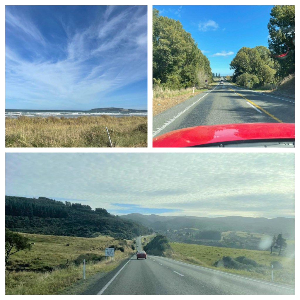
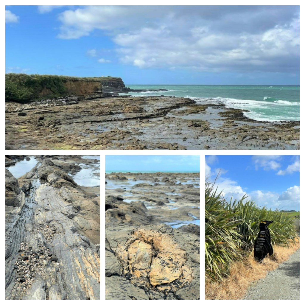
We left the city on State Highway 1, the longest and most significant road in New Zealand running the length of both islands.  Not surprisingly it is a good road and in this area, runs through picturesque farm land.  We tuned off the main road to head towards our first stop at Nugget Point.

Nugget Point gets its name from the gold nugget shaped rocks (some imagination is needed to see this shape) just of the headland.   From the car park area, it is just a short, relatively easy walk up to the lighthouse, which was built in 1869 and the viewing platform over the ‘nuggets’.   

Thankfully the sky had cleared and although it was not sunny, it was still beautiful with the sun breaking through the clouds on to the sea.   It was windy though and I could not stay on the exposed part of the viewing platform for too long with fear of being blown off lol!  There is a small sign near the track which describes Nugget Point as the “meeting place of rock and waves and wind and tide” – I think that sums it up nicely.

Back on the picturesque road again and the rain started again.  Of course, rain + sun = 🌈👍🏻.

Now there are many waterfalls in the Catlins, and if you have more time, you could spend an entire day visiting waterfalls alone.  Our one day whistle stop tour means we had to choose one, and we chose Purakaunui Falls. 

The falls were only a short 10 minute walk from the carpark, through a native podocarp and beech forest filled with beautiful bird song and just as we reached the falls, the clouds parted and blue sky appeared above the waterfall for the perfect picture 😁.   The waterfall is 20 metres tall and cascades over 3 tiers.  Apparently, it is one of New Zealand’s most photographed waterfalls and even appears on a postage stamp (if you remember those things lol).

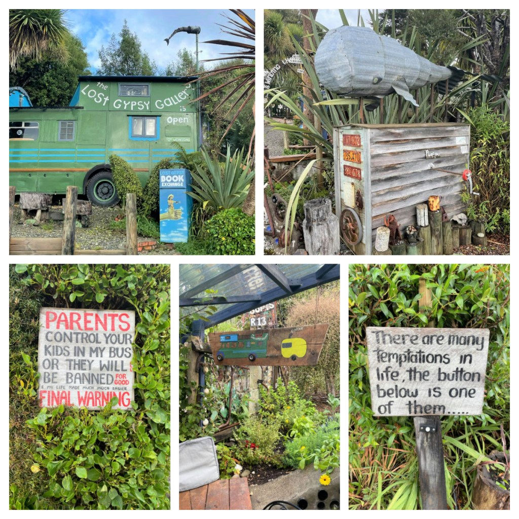
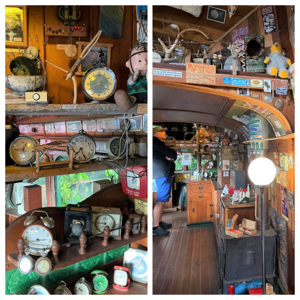
It may be worth noting that there is no phone reception in much of this area, so we were relying on the offline maps.me app to get around and we were initially concerned when it directed us along an unsealed road … but never fear, we finally made it out on the main road and we were soon at our next stop at the Lost Gypsy caravan were we had a quick break to caffeinate again 😂and grab an amazing freshly baked hot cross bun.   The caravan itself (and ‘museum’ in the surrounding area) is a weird collection of ‘automata and curios’ (one person’s junk is another person’s treasure) which definitely worth exploring if you have the time.

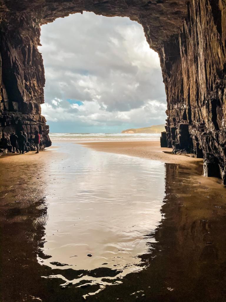
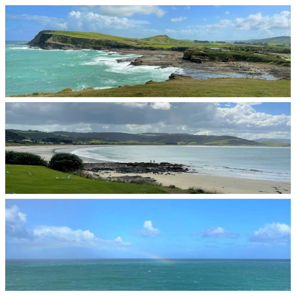
Back on the road and we had a quick stop at the Florence Hill look out for a view over the perfectly curved Tautuku Beach and out to the Southern Ocean before continuing on a few kilometres to the car park for Cathedral Caves.  We paid our small fee for the car park (more of a donation towards the maintance etc.) and headed down the track through the bush towards the beach.

The caves are only accessible 3 hours per day around low tide so planning was essential to make sure we were here at the right time.  It is also closed during the winter months.  It took us around 10 minutes down the bush lined track and 10 minutes along a beautiful wide wind swept beach – thankfully the sun was out again and it was not too cold.  I loved the bush lined beach.

There were a few people around, but not too many and we managed to avoid the larger family group which would have ruined all my photos 😂. 

The caves themselves have been gouged out of the Jurassic sandstone cliffs by the waves over tens of thousands of years and it is worth taking a torch (or ensuring your phone has a torch on it) if you want to explore the back of the caves.  They are up to 30 metres in height, resembling cathedrals (with some imagination).

It only took 12 minutes to walk/trot back up from the beach to the car park – my weekly hill walks must be paying off 👍🏻.

Just as we got back to the car park, it started to rain … the heaviest rain we had had during the day.  In fact, come to think of it, it seemed to rain every time we were in the car lol.

Our final stop was Curio Bay.  The home the endangered yellow eyed penguins and an incredible petrified forest.  Unfortunately, it was the wrong time of the day to see the penguins as they typically come in from their day at sea near dusk.  Of course, to see the petrified forest, we needed to be there around low tide and they did not correspond. 

The petrified forest dates back to the Jurassic period and the tree fossils you can see today, are approximately 170 million years old.  It was incredible that you can still see the rings of the trees in the ‘stone’.  The trees are the ancestors of Kauri and Matai, and were alive when New Zealand was part of Gondwanaland … if only those trees could talk.  It was a bit windy, but the sun was shining and the contrast of colours between the sky, the sea and the rocks was stunning. 

Just a short walk from Curio Day is Porpoise Bay.  You can probably guess that it is common to see Hectors dolphins in the bay.  We found a spot overlooking the bay to park up for lunch but unfortunately there were no dolphins today.  Before our long drive back to Dunedin, we took a  quick look at the view point over Curio Bay – guess what, it started raining and the wind picked up again, just as I was trying to take photos of birds in the distance but the wind was blowing me around on the exposed headland.   Again that amazing combination of sun and rain resulted in a  rainbow into sea 🌈.

We had an uneventful 2.5 hour drive back to Dunedin (if you don’t count the massive flock of sheep slowly making their way down the road) and the surf competition was still going (it started early in the morning).  We watched it for a little while before enjoying a well earned meal at Spirit House, an Asian fusion restaurant just a few minutes from our hotel – I highly recommend it if you are in the area. 

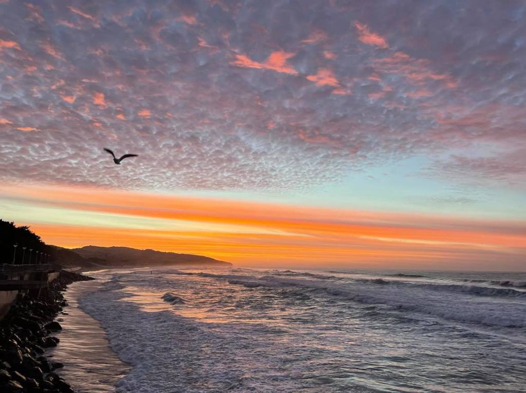
The next morning we had planned to have a relaxed morning and go for a walk but I woke to see red reflected in the windows of the houses across from us – that was it, I was dressed and out of there in a minute and boy was it worth it, what a beautiful sunrise.  (Not quite the pyjama clad dash I did in Stewart Island – at least this time I had clothes on 👍🏻 lol).

It was a lovely walk around to the Sir Leonard Wright lookout.   The walk took us along St Clair beach, through parks and a little along an ocean front road and then back along the beach – 8 km in total.  It was a great start to the day.

We headed back to the room to shower and change before driving into the city.  I bought a 50c map from the Information Centre and did a little self-guided heritage walk.  Unfortunately, the map didn’t give much information and had pretty poor photos showing the buildings, but it did give me some structure to my roaming so I guess it was worth the 50c?? lol

Dunedin’s history dates back to the arrival of Māori in around 1100AD.  Little evidence is left of their time here, in a place they called Ōtepoti, but it is considered that they survived on seal and moa.  Almost 600 years later, in 1770, Capitan Cook arrived in the area, quickly followed by European sealers and whalers decimating the local wildlife populations.   

The 1800’s brought the gold rush and a Scottish settlement, that turned in to New Zealand’s first city in 1865.  It was also the largest and richest city at the time.   The new settlers tried to replicate Edinburgh and many of the buildings from that time give the city the character it has today.  The name Dunedin come from the Scottish Gaelic name for Edinburgh – Dùn Èideann.   Apparently the ornate Victorian and Edwardian buildings are regarded the best collect of such architecture in the Southern Hemisphere.  Dunedin is also home of New Zealand’s first university – Otago, which was founded in 1869.

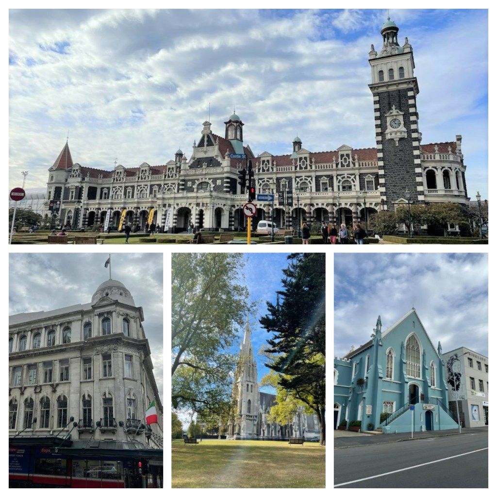
My walk ended up at the at the First Church, built in 1873 – the last time I was here photographing the church was 8 years ago, in the snow!!! This time I was fortunate to have some sunshine 👍🏻

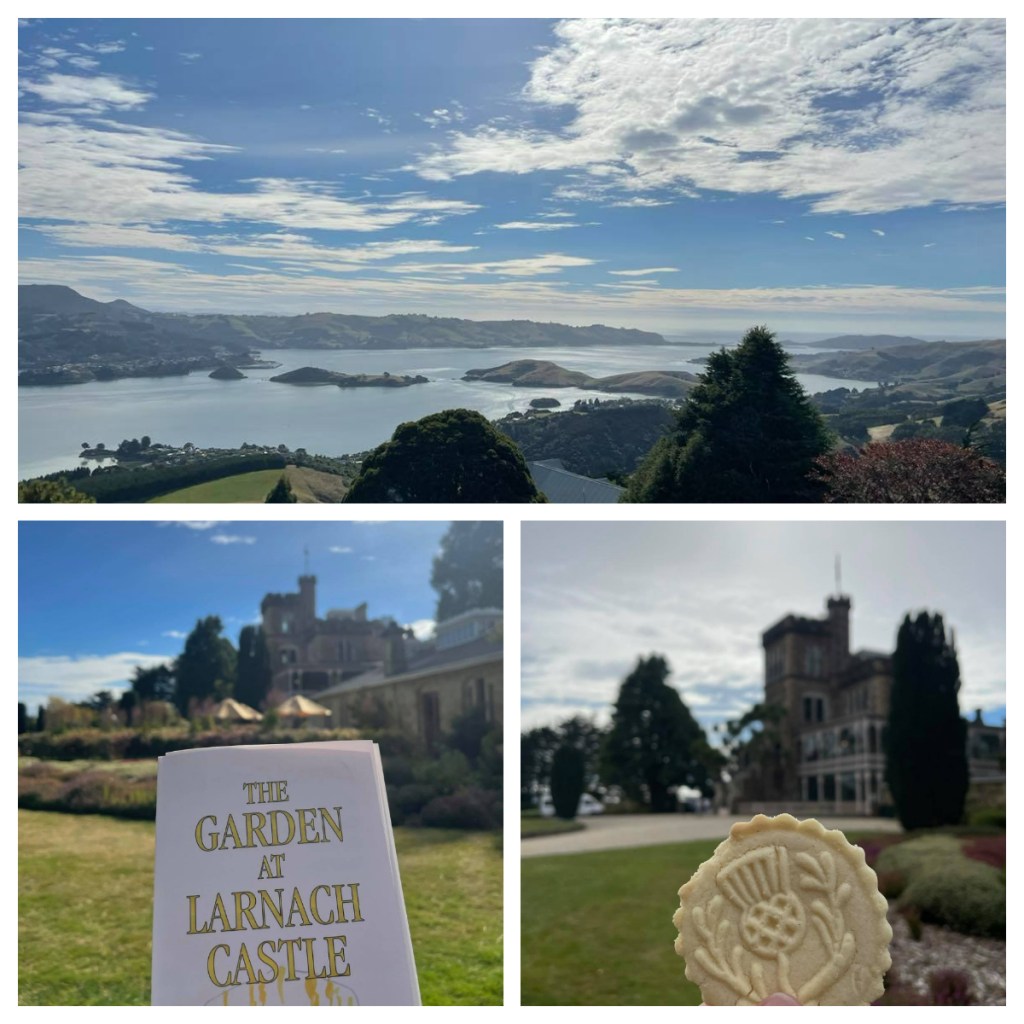
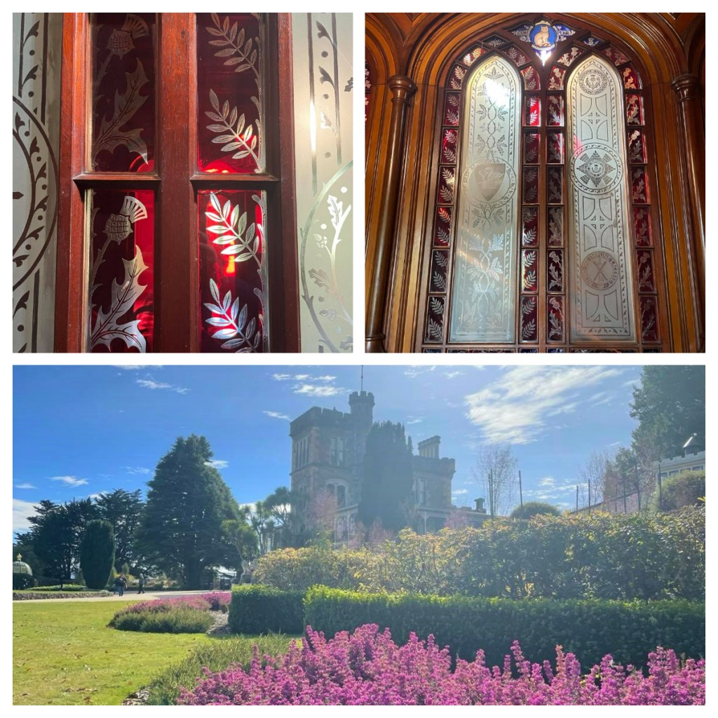
From the city, I drove out to the peninsula to Larnch Castle – a mock castle with beautiful views and stunning gardens with plants from all around the world.  Unlike the map I had in town, the entrance fee (you can pay to just look around the gardens or the gardens and castle) to the castle provides you with a brochure that has lots of information about the castle and grounds.

Despite all the “Scottishness”, the castle has no real Scottish roots and Larnch was actually born in Australia and lived most of his life there or in New Zealand.   (At that time, these settlers still considered themselves British despite never setting foot in the mother country.)

Apparently, it is New Zealand’s only ‘castle” and was built by European mast craftsmen in 1871 by William Larnch for his wife Eliza.  No expense was spared.  Unfortunately, over the years the castle and grounds was left and both were in poor condition when purchased by the Barker family in 1967.   They have spent the subsequent decades restoring both the castle and gardens to their former glory (and beyond the case of the gardens) and the entrance fees allows them to continue this work.

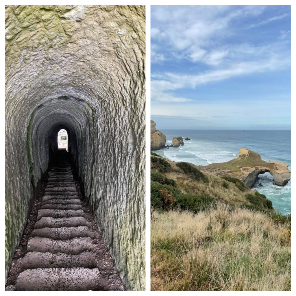
The final thing on my list for the day was a walk to Tunnel Beach, a beach just outside of the city.  OMG, the path down was so steep and I was already dreading the walk back up just a few minutes in to the walk down!  This is another beach that you can only access 2 hours either side of low tide.  On this day, low tide was 4.30pm and the track and its nearby on road parking was already busy at 3pm!   

After the steep path down, I reached the tunnel which was narrow and dark (it is a tunnel after all  🥴) but it was all worth it when I made it to the to the beautiful beach surrounded by cliffs

By the time I got back to our hotel, I had most definitely earned pizza for dinner!

Our final morning and it was 19c at 6.30am so I was up early again for a final walk along the sea front and beach.  The sunrise was not as nice as the day before but was so warm and beautiful and surfers were already out warming up for their competition.

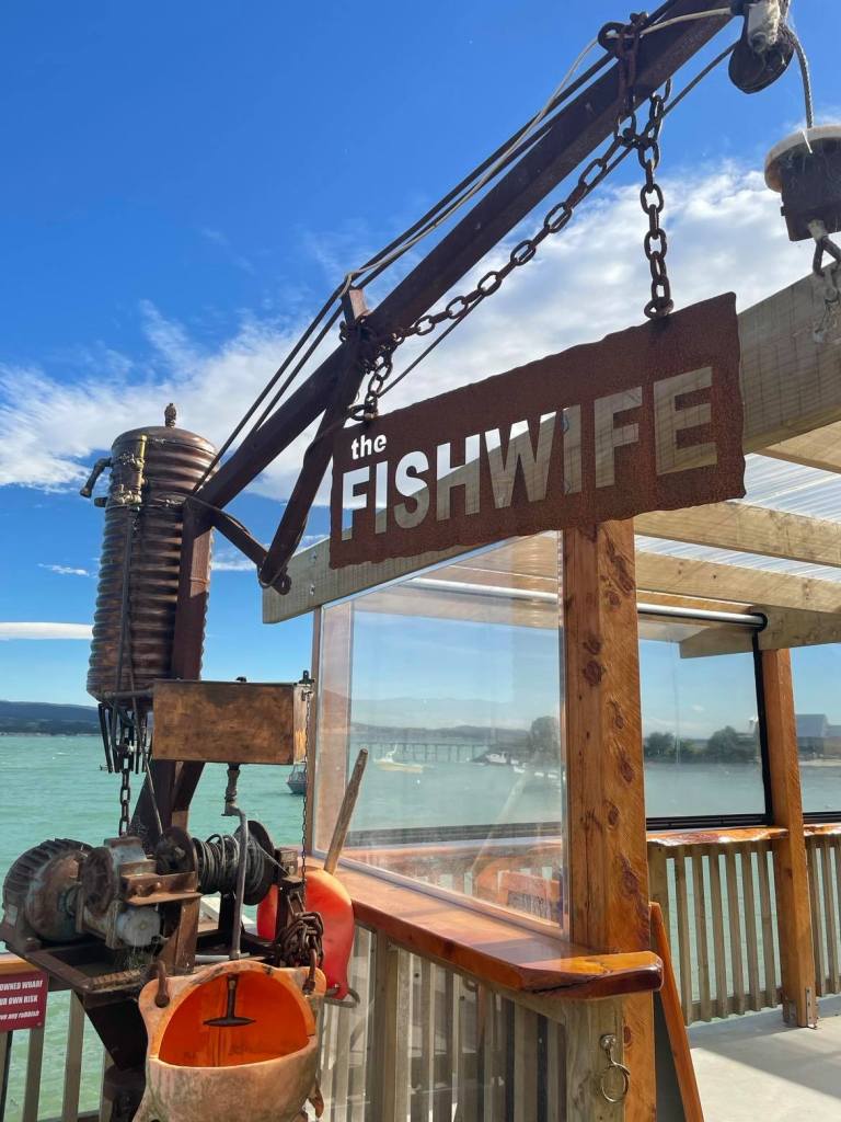
Sadly it was then time to get packed and head north, not without a short stop for lunch at the Fishwife at Moeraki village (yes, it is near the Moeraki Boulders).  They have great chips and are amazing for fresh Crays (if you like that kind of thing lol).

Its worth noting that Dunedin has so much more to do than just the mostly outdoorsy things I did.  It has a great museum, brewery tours, albatross and penguin colonies, wildlife boat cruises – definitely something for everyone!

To the end of Farewell Spit

December 2020

Our ride for the afternoon was a 4WD bus operated by Farewell Spit Eco tours.  They have been operating tours to the spit for over 70 years, and are the only company licensed to do so.   You are not allowed to drive on the spit, so the only way you can see it all is to take their tour – and it was definitely worth it. 

Despite the lack of international tourists, they were operating 3 buses on this day, so they are clearly still doing good business with kiwis exploring their own backyard.  Charles, a strapping Dutchman (who had lived in NZ for many years) was our guide for the day.  He described himself as guide, driver, photographer and part time dairy farmer from Motueka lol. 

As we headed west out of Collingwood, Charles told us all about the area and interesting bits and pieces about what we were passing.   We started with a brief lesson on Mt Burnet, New Zealand’s only dolomite mine (who knew!).  Dolomite is a hardened limestone and has a high magnesium content and is used in fertiliser and cattle supplements (to combat magnesium deficiencies).  It is also used to purify steel.

If we blinked, we would have missed the tiny town of Pākawau, another relic of the coal mining industry in the region, dating back to 1840. Today it is home to the Westhaven Littleneck clam beds and processing factory.  The clams are wild caught, stored in a pool to ensure they are not full of sand before being heat treated and snap frozen – they are then shipped all over the world.

Like Pākawau, Pūponga was also fairly easy to miss.  At the height of the coal mining, the town was home to over 500 people as well as being the main port in the Golden Bay area. Today just a handful of people live there.  The old wharf, once the longest in the Southern Hemisphere at 1km long, is long gone except for a few wooden pillars.  The coal was taken down the pier by a small train – a 6 tonne diesel powered train (affectionately known as Donald) would take coal to the coal barges sitting in the man-made channels.

When no longer in use, ‘Donald’ the Locomotive (who had arrived in New Zealand from Scotland in 1901) was abandoned in the water and left to rust away until he was rescued in recent years by members of the Blenheim Riverside Railway Society who spent thousands of hours restoring him to his former glory.

From ‘Port’ Pūponga we travelled inland, across the top end of the island towards out first spot at Cape Farewell, the northern most tip of the South Island.  We passed the site of a large Maori Pā (a hill fort) where there had been numerous big battles until the infamous chief Te Rauparaha arrived on one of his many invasions, destroyed the Pā and killed everyone!

Cape Farewell was the last point of New Zealand that Captain Cook and his crew saw when they departed in 1770 (well thought out place names strike again!).  We always consider the South Island being directly south of the North Island, when in fact they overlap quiet significantly and this point of the South Island is actually in line with Palmerston North in the North Island!

After an early attempt to drill for oil, which thankfully failed, much of the land in the area now provides a buffer to Farewell Split – this land today is partially farmed as well as allowing forest regeneration.

We had time for a brief walk around the cliff tops and take in the view, thankfully there were no mosquitos or sand flies … because it was too windy 🥴😬.

As we got back onto the bus and travelled towards the spit, Charles told us that there can be 14,000 black swans on farewell spit in season, self-populated from Australia in 1840s.  Apparently New Zealand use to have its own species of swan which was extinct before Europeans arrived – as with most of New Zealand’s extinct birds, it was much bigger and heavier than the modern day swans from Australia.  I can only imagine how amazing it must have been to have Moas, Haast Eagles and giant swans wandering around.

At around 30km long, Farewell Spit is the longest sand spit in New Zealand (growing annually) and today it is a nature reserve of international importance due to the bird sanctuary and wetlands.  The public can only access the first 4km (by foot) unless on a tour with Farewell Spit Eco tours (or part of DoC or Maritime NZ).  In fact, its status of international importance means it is more tightly managed than national parks with a few of the rules being that you can not smoke, nor can you remove anything from the Spit (though I think I had a fair amount of Spit sand in my shoes by the end of the day).

At the beginning of the Spit is Triangle Flats, according to Charles this was the site of large Maori battles and numerous tools, weapons and parts of large wakas (canoes) have been found in and around the area.  Apparently, the settlements here were not large, but both Abel Tasman and James Cook wrote about being approached by many waka filled with men (not particularly welcoming) – names such as Murderers Bay tells the story.   (Apparently, it was all just a big misunderstanding -the local iwi performed a haka (basically a war dance) and blew a conch shell and the Europeans thought it was a greeting rather than a warning and replied with a trumpet fanfare – a clear declaration of war!)  It is though that the Ngāti Tūmatakōkiri were killed off in an invasion by another tribe in the early 1800s.

Back on the Spit and we discussed how tidal the area is (the tides dictate what time the tours go) – being 2,000 hectares at high tide and 10,000 at low tide which is part of what makes it an important feeding ground for birds.  In fact, the region has a higher biomass than a rain forest with over 90 species of birds, crabs, insects etc.  

The base of the Spit used to be farmed, as well as being a popular area for hunting of birds until it became a nature reserve in 1938. It is not only a Ramsar Site – a list of Wetlands of International importance which provides a framework for international cooperation for the conservation of such sites but also a Flyway Reserve Network Site, a network of wetlands with significant importance for migratory shorebirds. 

We crossed over the Spit from the sheltered wetland southern side to the sandy, exposed northern side where Charles had to get out from time to time to check the sand conditions before driving on to the sand.    It was beautiful with kilometres of white sandy beaches and on this side, we are facing north, straight towards Mt Taranaki (if we could see) it. 

Our first stop was right on the base of the Spit at Fossil Point, which holds fossils from an old riverbed from the Cretaceous period (a mere 40 million years ago).  Fossil hunting was only interrupted by the random seals camouflaged as they lay around by the rocks.  The weather had started to turn a little and it had started to spit so we jumped back on the bus and heading further down the beach, past the public access area and beyond. 👍🏻👍🏻

As we drove slowly down the Spit, Charles pointed out just a few of the birds we spotted, including Godwits (Charles was really excited to see them.)  Did you know that Godwits have the longest migratory flight of any flapping bird, taking 9 days from Alaska to NZ non-stop, losing half their body weight during the journey?  Legend says that a Godwit sat on the shoulder of legendry Maori voyager Kupe, guiding him to Aotearoa.

We also saw dotterels, variable oyster catchers, black back gulls and Caspian terns (the largest tern in the world) hanging amongst white fronted terns who are almost identical except for size (Caspian tern being almost twice the size of the other).  The White fronted terns have only just started breeding again on the spit 👍🏻 Unfortunately, there are no photos as we didn’t stop and there was rain on the windows of the bus.  😢

According to Charles, variable oyster catches have the fastest growing beak in the bird world – 0.4mm a day!!   They are also show resource polymorphism – their beak can change shape depending on the food source.   They can be long and sharp for ‘stabbing’ food, or short and stout for shovelling.  Sounds to me like Charles Darwin should have done a study on Farewell Spit as well as in the Galapagos Islands!

Charles was clearly very passionate about the history and wildlife of the area that he enthusiastically educated us about on the drive. 

We passed a massive tree stump which was washed up in a flood in 2010.  On the stump was 2 pied shags – the story goes that they arrived on the stump, as there never used to be pied shags on the Spit before the arrival of the stump!   

The Spit is currently growing, getting longer and wider.  Some think it will eventually attach itself to another island or piece of land as it continues to grow.  It is clear how much it has grown when we got to the lighthouse compound – which use to be at the end of the spit and is now a number of kilometres inland!   However, it is highly likely that some of the sand will blow away again!  Only time will tell.

Towards the end of the Spit, there was no vegetation – nearer the base of the Spit, Maram grass had been planted over the years to stop the erosion of the dunes (they move roughly 30 metres per year).  That said, it is believed that the part of the spit was once covered in forest and moa bones have been found in nearby Maori middens.

Despite Abel Tasman clearly mapping the Spit, lots of ships have beached on it (Captain Cook did not see it at all due to poor weather), so in 1870, a 30m high lighthouse was built on the end of it, in a compound with 4 houses.  (As I previously mentioned, when built, the lighthouse was on the end of the Spit!) 

As nothing would grow in the sandy ground, with no fresh water, all suppliers for the lighthouse keepers and their families have to brought down the Spit by horse and they were always digging the house out of the moving sands.  It was apparently the least desirable lighthouse posting in the country!

In 1890, one of the lighthouse keepers started getting soil from town every couple of weeks and planted a windbreak of macrocarpa trees that we still see around the compound today.  This protected the compound from the wind and sand and enabled the families based there to start grow some of their own produce.

In 1897, the wooden lighthouse was replaced with a steel lighthouse, which was converted to electric in the 1930s.  The electricity was only for the lighthouse and the lighthouse keepers and their families were not allowed to use it till 1957.  The last lighthouse keeper left in 1984 (from what use to take 3 keepers to maintain), with the original electric light being replaced in 1999.

Anything orange on today’s lighthouse is from the original lighthouse and the feet are painted red – why you ask?  Apparently, it was in support of the Team New Zealand in the Americas Cup champaign – Sir Peter Blake started a traditional of red socks in 1995 in support of the team.

After taking a break for afternoon tea in one of the old houses, we were back on the bus and back down to the beach. 

In the distance, we saw what I thought was a dog running across the beach, it was in fact a seal (which makes far more sense).  I have never seen a seal run so fast, when it reached a small area of water, it skidded across on its belly before jumping back on its flippers and continuing to run.  We think it was chasing another one we had seen nearby – males are very territorial!

A little further down the Spit is a large Gannet colony housing over 10,000 birds.  It is in fact the only gannet colony at sea level (they are normally on high rocks over the sea).  Farewell Spit Eco tours actually run another tour specifically to see the Gannets but as we have a few minutes to spare Charles decided to do a sneaky drive down the Spit to see some of the Gannets flying around and the colony in the distance …. the wind had picked up and this open end of the spit was incredibly windswept.    The sand blasted us as we stepped out of the bus but at least the sun was shining, and I was happy to have the opportunity to see them.

Our final stop on the Spit was at the sand dunes and the highest point of the island, where we had some time to walk up the dunes (or run in my young energetic nephew’s case)!  It was great fun (and my nephew’s favourite part of the day) and I enjoyed the amazing patterns in the wet sand.

The wind continued as we drove back down the Spit, and the surface sand was now being blown along – it looked like we were driving through a river of sand with currents running through it.

It had been a long day, but I highly recommended the tour.